
| Нo | Название | Описание |
|---|---|---|
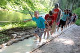 |
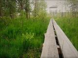
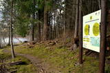
The first barefoot trail created in the Baltic States in the recreation complex "Valguma pasaule", which is located on the forested shores of Lake Valguma. When walking on the path, the feet "massage" sand, wood chips, clay, peat, gravel, cones and various other materials. |
|
 |
Dabas takā gar Rojas upi iespējamas 3 dažāda garuma distances, kas lokveidā ved gar upi un tai pieguļošajiem mežiem – 2 km, 7 km un 15 km, kas katra atzīmēta ar savas krāsas norādēm. Dzeltenais aplis 2 km, zilais aplis – 7 km, sarkanais aplis – 15 km. Maršrutus var veikt arī ar velosipēdu, taču braucot ar velo, atsevišķi posmi var būt grūti izbraucami smilšu dēļ. Pie upes ierīkotas vairākas atpūtas vietas ar soliem, galdiem, labierīcībām, šūpolēm, vingrošanas konstrukcijām, atkritumu urnām, kā arī ugunskura un telšu vietām. Pie atpūtas vietām Žocenē un Rojā ir izveidotas arī laivu piestātnes. Takas sākumā upes krastā labiekārtota vieta, kur upē ietek Rojas avots, ko kā ūdensņemšanas vietu iecienījuši vietējie iedzīvotāji. |
|
 |
Познавательная тропа длиной 1,2 км знакомит с многовековыми, занесенными песком соснами. У тропы – в конце бывшего «тира» (полигон Советской Армии) - построена смотровая башня. |
|
 |
1,2 km garā taka atrodas netālu no vietas, kur Gauju šķērso Vidzemes šoseja (A 2). Izejot taku, var iepazīt vienu no Latvijas augstākajiem dolomītiežu atsegumiem – Randātu klintis, kas paceļas 25 m virs Gaujas. Taka ir apļaveida un tās apskatei nepieciešamas ~ 45 minūtes. |
|
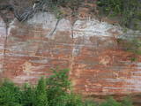 |
One of the most popular areas of uncovered sandstone in Latvia, known for its unusually smooth and sound-reflecting cliff wall (around 12m in height). Located on the right bank of the Salaca river, there is a place for tenting. A fun experiment is to stand in various closes opposite the cliff and to speak quietly. The echo will be heard either by the speaker or by people who are standing elsewhere. Located in the Salaca valley nature park and the Skaņaiskalns park.
|
|
 |
Тропа природы "Изгибы реки Риваc" начинается возле Улмалес-Лабрага лютеранской церкви и ведёт 3 километра вниз и вверх по обрывистым берегам реки Рива. Река здесь течёт по глубокому живописному оврагу глубина которого достигает 12 метров. Вы увидете бесчисленные речные повороты и крутые прибрежные скалы. Тропа частично доступна с ассистентом, тропа отмечена зеленой краской. |
|
 |
This is a route for hikers and bicyclists, starting at the village of Vaidava and then moving along the eastern shore of the narrow Lake Vaidava, which has steep cliffs around it. The trip covers the Veļķi baronial estate, the “Swedish pine”, the famous Vaidava (Metimne) hillfort, a series of streams, the great Rubene rock, the Vaidava baronial estate on the western shore of the lake. After that, the trail leads the visitor back to the starting point.
|
|
 |
Pie Gārsenes pils atrodas bijušais muižas parks 4ha platībā un pie tā sākas arī Gārsenes dabas takas. Dabas takas vēsturiski tika veidotas vienlaicīgi ar pils kompleksa būvniecību un ieeja takās atrodama pie mākslīgi veidotā, ar bruģa pamatni izliktā barona peldēšanās dīķa. Takas sākumā saglabājusies ošu aleja, ko savulaik stādījis barona dārznieks, savukārt taku vidusposmā apmeklētājiem ir iespēja pasēdēt uz Barona krēsla - akmens ar cilvēku veidotu sēdvietu tajā. Kopumā Gārsenes mežā vijas dažāda garuma labiekārtotas pastaigu un izziņas takas - Kultūrvēsturiskā taka, Zaļā taka, Baronu pastaigu taka, Staburaga taka, ar ierīkotām atpūtas un ugunskuru vietām. Takās apskatāmi vairāk kā 40 unikāli dabas objekti, gan dižakmeņi, gan dižkoki, kā arī un pagasta ievērojamākie arhitektūras un kultūrvēstures pieminekļi. No 2016.gada maija Dabas takās ietilpst arī „Krēslas stundas taka”, kas īpaši patiks zinātkāriem mazajiem ceļotājiem. Taka stāsta par Rūķu dzīvi mežā un tās veidošanas pamatā ir stāsti no „Lielās Rūķu enciklopēdijas”. |
|
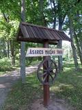 |
Asares muižas romantiskā stila dendroloģiskais ainavu parks veidots 18. gs. un papildināts 19. gs. 2. pusē. Muižas parka teritoriju ieskauj laukakmeņu mūris. Bet parkā sastopamas daudz interesantas krūmu un koku sugas: Sibīrijas baltegles, Eiropas lapegles, duglāzijas, šķeltlapainie baltalkšņi, Švedlera kļavas, košumkrūmi, dažādi lakstaugi. Liepu alejā - 2 dižkoki. Tempļa kalna atjaunotajā lapenē - muižnieku tējas dzeršanas vieta ar skatu uz pili. |
|
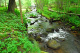 |
A pathway of wooden trails and little bridges, featuring the most beautiful part of the Ieriķupīte river, with several waterfalls, an old windmill, a unique millwheel, and various areas of obstacles for active people in the company of a guide.
|
|
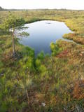 |
This territory was established to protect the rare tree specie in Latvia - common hornbeam, which covers approximately 4% of the territory, but the most visually interesting part of the area is the Tīrspurvs swamp, also known as the Dunika heath. This is where the visitor will find Latvia’s longest and most impressive swamp footpaths, which crosses the area from the North to the South. Visitors will be fascinated by the unique landscape of the central part of the swamp, where in some places there are not even small swamp pine trees. Various habitats will be found – small swamp lakes, mineral islands, marsh pools, etc., and that is to say nothing of all the birds in the area. |
|
 |
Круговая тропа длиной 1,2 км рядом с маяком Шлитере ведет вниз с Голубых гор или древнего берега Балтийского ледового озера и продолжается вдоль лесов и болот прилегающей равнины. |
|
 |
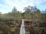
Taka ved cauri mežam uz skatu torni purva malā. Takā apskatāma Nāzara priede –priede, pie kuras 1905. gadā nošauts dumpinieks, pati priede – ekoloģiskais koks ar dzilnu kaltiem dobumiem, nokaltusi. Melnalkšņu dumbrājs - slīkšņa ar cūkaušiem un puplakšiem. Oleru purvs no skatu torņa – pārejas un sūnu purvs, kas izveidojies nolaista ezera vietā. Papildus objekti blakus takai, pieejami pa ceļu – Oleru muižas komplekss, Krustakmens, Oleru muižas kapi. Kopējais takas garums: 1,1 km. |
|
 |
Near the Priedīši homestead, there is a nature trail which allows visitors to study Lake Dziļezers and the surroundings. There are various lakes in this region which are found in a depression left behind by the Ice Age – Lake Dziļezers, Lake Riebezers, Lake Mazezers, Lake Auziņš, Lake Skuja and Lake Bruņķītis are all there. Along their shores, there are various kinds of forests, including ones with broadleaf trees that are under environmental protection. The trail is 3km in length and will take an hour or so to traverse. This is a part of the environmentally restricted territory of Lake Dziļezers and Lake Riebezers.
|
|
 |
Here you can cross a swamp without getting your feet wet and enjoy the local environment, which has been little touched by humankind. You can take the dam of the former Smiltene-Valmiera-Ainaži narrow gauge railroad. It crosses the swamp from the South-East to the North-West and is three to four km in length. There is also a circular wooden pathway on the eastern side of the dam. The length of the trail (including the dam) is around 5km, and it will take 90 minutes to two hours to traverse. The area is covered by environmental restrictions.
|
|
 |
4 km garā un marķētā taka iepazīstina ar dziļo Imulas ieleju – Abavas kreisā krasta pieteku. Īpaši iespaidīga ieleja izskatās bezlapu periodā, kad ir apjaušami tās izmēri un formas. Vēstures cienītāji var upes gultnē uzmeklēt Langsēdes Velna pēdas akmeni. Atrodas dabas parkā „Abavas senleja”. |
|
 |
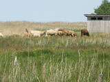
The nature trail was built in 2003 supported by the WWF, the Latvian Environment Protection Fund, the International volunteering organization supporting conservation initiatives in the United Kingdom (BTCV) involving volunteers from Nīca and Rucava municipal parishes. The trail exposes the surrounding landscapes and related biotopes – dunes, forest, grasslands and bog, as well as bird and animal species found there. On the trail, there is a bird watching tower and two birdwatcher hides. You can see the rivers Paurupe and Līgupe, beaver activity areas, grasslands, black alder forest, spruce forest, floodland, wild horses, aurochs, the Šķilu lime tree, the Holy Grove, the Ezerskolas sacrificial stone, the Pape ornithological field station, the Papes polder grasslands and the Pape lighthouse. There are resting places en route. The trail leads through the historical Ķoņu village with the traditional coastal fishing village architecture of buildings and yards. The trail is 9 km (5 km one way by a gravel road, returning 4km along the coastline). The trail is in the Pape nature park
|
|
 |
Takas sākums atrodas pie Veclaicenes pagasta pārvaldes (autosvālaukums). Tā izlokas gar Ievas, Trumulīša un Raipala ezeru dienvidu krastiem un pa ziemeļu krastu nogāzēm atgriežas atpakaļ sākumpunktā. Apļveida takas garums – ap 8 km. Atrodas Augšzemes aizsargājamo ainavu apvidū, Kornetu – Peļļu subglaciālajā vagā. |
|
 |
Dabas parkā izveidota Baltijā vienīgā Bišu taka, kurā apmeklētājs var iejusties bites ‘’lomā’’. Zinātkārie var ieģērbties bitenieka tērpā un novērot bišu dzīvi stropā vai kāpt kokā ar seno dravnieka ierīci – dzeini. Ekskursija, Bišu, Putnu, Meža, Sporta un Augu takas. |
|
 |
Overgrown with reeds, full of seashore meadows, lagoons, muddy little lakes and sandy shallows – this is the part of the Bay of Rīga shoreline which runs between Ainaži and Kuiviži. The Randi meadows are an important location for birds and plant life. It is a protected habitat with environmental restrictions. A bird-watching tower and nature trail have been installed so that visitors can study the meadows. The tour will take around one hour to complete. Objects are in the Northern Vidzeme Biosphere Reserve.
|
|
