
| Нo | Название | Описание |
|---|---|---|
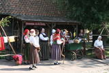 |
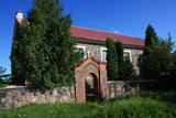
2003.gada decembrī folkloras kopa „Atštaukas” izveidoja folkloras centru „Namīns”, kurā svin svētkus, organizē Jāņu ielīgošanu, Lieldienu iešūpošanu, Miķeļdienas tirgu, Annas dienas Saimnieču svētkus, tautiskos Ziemassvētkus. „Atštaukas” palīdz saglabāt un popularizēt dažādus latviešu tautas godību rituālus, gan kāzu, gan arī bēru tradīcijas. Folkloras centrā „Namīns” darbojas arī skola, kurā bērniem tiek mācīta folklora un tautas tradīcijas. |
|
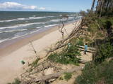 |
Начинается в нескольких километрах к северу от Павилосты и заканчивается недалеко до Ошвалки, протяженностью > 30 км. Его внушительные и необыкновенные формы просматриваются на участке Странте - Улмале, но и открывающиеся в окрестностях Юркалне (благоустроенные места для подхода, лестницы, автостоянки) виды (высота до 16 м) оставляют незабываемое впечатление! Отвесный берег рекомендуется наблюдать (смотреть, фотографировать) после сильных бурь, потому что во второй половине лета его обнажения (главным образом, песчаник, глина) выглядят менее выразительными из-за оползней и покрывающей растительности. Предыдущее название Юркалне – Феликсберг означало Счастливая гора. Теперешнее название это место получило в 1925 году. |
|
 |
Mузей Миервалдиса Кемерса –
известному работнику культуры Латвии (1902
1980) – священнику и художнику посвящен
мемориальный музей на улице Дубрес 21.
|
|
 |
Жагаре с давних пор славится особым сортом вишен «Žagarvyšnė» («Жагарская вишня»). Существует несколько разновидностей этого сорта, которые различаются по времени созревания, урожайности, форме деревьев и другим признакам. Эти вишни и сейчас растут почти в каждом местном саду, став уникальным символом поселка Жагаре. |
|
 |
Находится в историческом центре Субате. Здание построено из валунов (без башен) в 1831 году на средства графа Михаила Зиберга – Платера. Перед храмом возвышается впечатляющая звонница. В церкви установлена скульптурная группа «Голгофа» конца 18 века, распятие и выразительный рельеф главного алтаря - резьба по дереву. Последний создан по мотивам знаменитой фрески Леонардо да Винчи «Тайная вечеря». |
|
 |
Рагациемский мыс – выступ западного
побережья Рижского залива,
заканчивающийся мелководьем и
каменистой подводной мелью на расстоянии
несколько сот метров от нынешнего
побережья. В конце мыса столбцы
Рагациемского маяка.
|
|
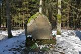 |
Находится недалеко от автодороги А 9, к западу от дома Батаров, где 22 марта 1919 года состоялся бой между бригадой генерала Яниса Балодиса и большевиками. Открыт в 1936 году. |
|
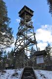 |
This recently built 26-metre wooden tower is on Ūdri Hill (58 metres above sea level). It is on the north-eastern shore of Lake Usma, less than one kilometre from the lake. The tower offers an excellent view of Lake Usma, its islands, and the vast forests which surround it.
|
|
 2 дня
|
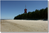
This section of the seacoast of Vidzeme is of outstanding scenic beauty with a lot of rocky capes and boulders in the sea alternating with small, sandy coves where the small streams and rivulets, which dry out in summer, flow into. Occasionally, the beach is completely covered with the gray backs of stones. In Zvejniekciems you need to make a detour around the estuary of the Aģe River and the Skulte port. In some places, small patches of reeds appear, while near Tūja you will see the first sandstone outcrops. Some part of the route can be covered via the beach or via a trail meandering through the dune forest with old pines. At the end of the route, you can see the unique lamprey fishing method - Svētupes nēģu tacis. |
|
 8 дней
|
Для этого маршрута характерно ощущение лета, т.к.он практически не отходит от моря. Латвийский морской курорт Юрмала привлекает своими характерными деревянными коттеджами 19 века, концертным залом Дзинтари и оживленным пляжем. Мыс Колка находится в Национальном парке Слитере, в котором также расположены традиционные деревни самой малочисленной этнической группы в мире — ливов. Насладитесь пустынными пляжами и копченой рыбой местного приготовления. Вентспилс — город безупречного порядка, с его средневековым замком и благоустроенным пляжем. Павилоста — неофициальная столица латвийского виндсерфинга, в то время как в Паланге в Литве находится отличный Музей Янтаря. Жемчужина Литвы- это Куршская коса с ее лагуной, которая привлекает своими обширными песчаными дюнами и Нида, очаровательная деревня с музеем Томаса Манна. Обратно в Латвии, посетите Лиепаю — интересный город с его историческим кварталом, пляжем, оживленными ресторанами и клубами и ярко выраженным военным наследием в виде бывших военно - морских фортов и военной зоны. Кулдигу любят художники за ее живописные маленькие мощеные улочки с деревянными домами и самым широким водопадом в Европе на реке Вента. |
|
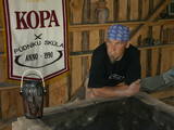 |
Один из участников общества Латвийского Фонда культуры «Школа гончаров» («Пуднику скула»), который использует старинные и проверенные веками методы гончарного дела Латгалии. Предлагает семинары, участие в открытии печи, возможность поработать самим, заказ и покупку керамических работ. |
|
 |
Хозяин свое пчеловодческое хозяйство основал на красивом берегу озера, на месте старинного жилья, расположив пчелиные улья в двух местах – на приозерном холме и на красивом лесном лугу, который хозяин преобразовал сам. Рядом с пасекой находится красивый яблоневый сад, в котором осенью хозяин рад видеть помощников. С 1996 года хозяин понемногу обновлял и ухаживал за этим хозяйстом, в котором уже красивое широкое озеро, домик у озера, клеть с отремонтированным помещением над клетью и балконом, пасека и яблоневый сад. |
|
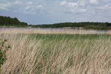 |
The main “treasure” in this restricted area is the shallow and eutrophic lake, which is home to many important birds. The lake and its flood-land meadows also feature many different plants. The Svētupe River flows from the northern part of the lake.
|
|
 |
Находится в центре Балви, на обочине улицы Бривибас (Валкское направление). Предлагает «домашние блюда», поэтому слывет излюбленным местом, где можно вкусно пообедать. |
|
 3 дня
|
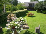
Данный маршрут предлагает осмотреть прекрасные сады в Латвии и Литве. В мемориальном саду Эдварда Вирзы можно увидеть деревья, которым посвящены стихи. Э. Вирза был латышским поэтом и писателем, написавшим роман «Страумени» о жизни латышских крестьян. В Струбергском декоративном саду предлагают экскурсию и консультации по садоводству. В усадьбе Брукнас вы сможете осмотреть сад, который был построен как парк эпохи Возрождения, розарий и виноградник. Красивая усадьба 18-го века Мазмежотне была восстановлена семьей зернопроизводителей. Рундальский дворец известен как жемчужина Латышского барокко и рококо, где можно посетить розарий и увидеть с более чем 2200 сортов роз. В поместье Бланкенфельде вы сможете увидеть уникальную коллекцию колоколов и насладитесь натуральными соками, сиропами и соленьями, приготовленными на месте. Посетив Домик перечной мяты, вы сможете насладиться мятным чаем, печеньем, медом с мятой и мятным сиропом. Следующая остановка – фермерское хозяйство «Дроши веселс», где выращивают овощи и производят лекарственные мази. В Литве вы можете посетить Жагаре (Žagari), известный своим вишневым садом - парком и особенным сортом вишни – «Жагарвишне» ("Žagarvyšnė"), включенным в национальный список сортов растений. Посетите приусадебный парк в Жагаре, в котором произрастают более 100 видов деревьев и кустарников. Вернувшись в Латвию, вы можете устроить пикник в дендрарии «Вилки», в котором растут около 1000 различных растений - как типичных для Латвийского пейзажа, так и уникальных. В питомнике по выращиванию саженцев в Залениеки вы можете прогуляться по дендрарию, где увидите более 2000 деревьев и кустарников. Красотой пионов можно насладиться в коллекционном саду Андра Беркина, а поблизости, в Виестарде в Кроньауце вам предложат экскурсии в великолепном саду тюльпанов. Живописный сад семьи Клуга славится бегониями, в свою очередь в Добельском институте садоводства имеется коллекция из более чем 200 сортов сирени. Сад красивых и практичных идей может похвастаться своей коллекцией хвойных деревьев, а владельцы предлагают продегустировать порошки из пряных трав, сушеные ягоды и фрукты. «Чай гномов» - одно из самых больших хозяйств по выращиванию лекарственных трав в Латвии (выращивают эхинацею, ноготки, ромашку и др.). Наконец, посетите питомник по выращиванию саженцев деревьев «Лиепас», специализирующийся на выращивании фруктовых деревьев, ягодных кустарников и роз. |
|
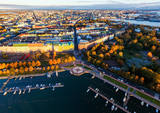 |
Helsinki is the capital of Finland and the biggest city in Finland. It offers a lot to see as it is seaside city surrounded by islands but city itself is full of wonderful parks. This city has everything to attract all kinds of people - from architecture and culture to nature and even has wide range of places where to enjoy night-time Helsinki. |
|
 |
Находится на левом берегу реки Мемеле, 1,1 км севернее населенного пункта Бангас. Вилис Плудонис (1874 – 1940) был выдающимся латышским поэтом, представителем народного романтизма и учителем. Вилис Лейниекс (настоящее имя) родился в Бауском уезде в семье хозяина хутора «Лейениеки» Яниса Лейниека. На маленького мальчика уже в детстве оказали влияние сказки, рассказанные бабушкой, рассказы и народные песни. В. Плудонис похоронен на семейном кладбище (кладбище Плудоне), находящемся недалеко от дома (0,3 км). В «Лейениеки» создана экспозиция, знакомящая с жизненным путем и творчеством поэта. У Заячьей баньки ожидают зайцы – по мотивам стихотворения «Заячья банька». |
|
 |
В хозяйстве производят продукты переработки молока и выращивают клубнику. Гостям предлагается освоить навыки выпечки ржаного хлеба, приготовить сыр и мороженое домашним способом и увидеть животных (овец, коз, свиней, телят, коров, лошадей, кур, кроликов, морских свинок и др.). Энтузиасты могут попробовать свои силы на сельскохозяйственных работах. Дегустация и приобретение продукции. |
|
 |
Atrodas 200 m ziemeļaustrumos no akmens tilta pār Tebru. Ūdensdzirnavu komplekss celts 18. gs. beigās – 19. gs. sākumā uz Tebras upītes, uzpludinot Dzirnavdīķi. Blakus dzirnavām atrodas 19. gs. beigās celtā Aizputes muižas alusdarītava, apvienojot divas vecākas Pilsmuižas saimniecības ēkas. |
|
 |
Находится со стороны дороги Двиете – Бебрене. Восстановленное строение возводилось в 1874 году. После Первой мировой войны до 1929 года амбар использовался как моленная до тех пор, пока не была восстановлена Двиетская католическая церковь.
|
|


