
| Нo | Название | Описание |
|---|---|---|
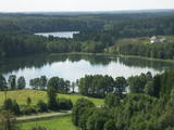 |
This territory is rich with forestland and lakes (some 285 in all). There are extensive opportunities for active recreation or calm leisure.
|
|
 |
Осенью 2010 года на берегах пограничной реки Койва, разделяющей Эстонию и Латвию, открылась велосипедная дорожка длиной 60 км, знакомящая посетителей с объектами культурного наследия двух государств. Тропа начинается с парковки Теллингумяэ, на конечных пунктах тропы и в месте пересечения границы есть места отдыха и инфотаблички с общей схемой тропы. Указатели направлений установлены на таких перекрестках, где путешественник может растеряться. |
|
 7 дней
|
Вначале маршрут идет к производителю вина и березового сока, где вы сможете отведать эти традиционные и освежающие напитки, а затем отправляйтесь на козью ферму, где можно дегустировать различные молочные продукты и посмотреть на животных. Затем направляйтесь в Сигулду с ее Олимпийской бобслейной трассой и тремя средневековыми замками, расположенными на берегах реки Гауя – Сигулдой, Турайдой и Кримулдой. Здесь также много живописных троп. Затем откройте для себя историческую деревню Лигатне, основанную вокруг бумажной фабрики, а также посетите местных ремесленников, которые расположились в одной из пещер, типичных для этой местности. Цесис – очаровательный город с его внушительными развалинами средневекового замка и Новым замком. Посетите выращивателя конопли и попробуйте коноплю, приготовленную традиционным способом. Насладитесь визитом на мельницу Кони, где производят шерсть с помощью старинных станков и делают теплые одеяла. Посетите ремесленную студию в Стайцеле и попробуйте разглядеть, где находится колония аистов с более чем 30 гнездами вдоль дороги. В Мазсалаце находится природный парк с тропами вдоль красивых крутых берегов реки Салацы. Река славится своими миногами, и далее на маршруте вы сможете увидеть традиционные запруды для ловли миног. В Саулкрасты пройдитесь по тропе вдоль дюны и насладитесь пляжем. Затем отправляйтесь на клюквенные болота, где сможете отведать эту полезную ягоду в одном из видов, типичных для сезона. Посетите элегантное поместье Бирини с его огромным парком и замечательным рестораном, а затем возвращайтесь в Ригу. |
|
 3 дня
|
This tour will take you on a walk through the Curonian Spit from Nida to Smiltynė. The Curonian Spit National Park is located on a long, sand-dune spit that separates the Curonian Lagoon from the Baltic Sea coast. A sand beach of ~50 km is running on the western side of the dune spit, while the shore of the Curonian Lagoon is shallow and characteristic of ridged bays overgrown with reeds. The Baltic Coastal Hiking Route starts in the centre of Nida near the port. In Nida, it runs along the Curonian Lagoon promenade, offering beautiful views of the spacious waters. From Nida to Bulvikio Cape, the Baltic Coastal Hiking Route winds along small forest paths leading up and down pine-covered dunes; in the village of Preila, the trail runs along the promenade of the lagoon. Between Pervalka and Juodkrantė, the Baltic Coastal Hiking Route leads along a beautiful, sandy beach. You can take the Raganų kalnas (Hill of Witches) trail in Juodkrantė. The route alternates between the Baltic Sea coast, the dunes and the Curonian Lagoon until it finally reaches the ferry, which will take you to Klaipėda. |
|
 |
В большом загоне, который доступен для детей и их родителей в качестве знакомства с живой природой, пасутся козы, свиньи, домашние птицы и другие животные. Можно понаблюдать за кроликами. В сезон предлагаются яйца домашних птиц. |
|
 |
Ārkārtīgi ainaviska teritorija Augšzemes augstienes centrālajā daļā ar vairākiem ezeriem - Medumu, Lielo un Mazo Ilgas, Šķirsteņu un dažām mazākām ūdenstilpēm. Medumu ezera salām ir dabas lieguma statuss. Teritoriju šķērso vairāki grantēti ceļi, no kuriem dažviet paveras brīnišķīgas, bet nelabiekārtotas skatu vietas. Teritorijā atrodas Medumu katoļu baznīca. Piemērota teritorija dažādu aktīvā tūrisma veidu attīstībai. Dabas parks ietilpst Augšzemes aizsargājamo ainavu apvidū. |
|
 |
В фондах музея хранится более 120 000 предметов, экспозиция представляет историю Лиепаи и юга Курземе – начиная с каменного века и вплоть до 19-го века. Посетителям предлагается также экспозиция, посвященная жизни и творчеству скульптора по дереву Микеля Панкока (1894-1983). В других выставочных залах периодически проводятся выставки современного искусства. |
|
 |
АО «Латгалес пиенс» является единственным молокоперерабатывающим предприятием в Латвии, производящим сыр «Теяс» из цельного молока и с различными вкусами. Предприятие также производит копченый колбасный сыр, сыр для салатов и сырочки «Гардуминьш» из сладкой творожной массы, а также другие виды молочных продуктов. Продукцию можно приобрести на Даугавпилском рынке, Рижском Центральном рынке, а также во всех торговых местах АО «Латгалес пиенс» по всей Латвии. |
|
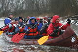 |
Компания занимается организацией природных походов: летом морские походы на байдарке, осенью на болотоступах по болоту, зимой походы на снегоступах и весной на каноэ по рекам. |
|
 |
Предприятие организует природные походы, целью которых является знакомство с природой (наблюдение за тюленями, пешие, велосипедные и лыжные природные походы, на резиновых лодках по островкам национального парка Вилсанди, вылазки к орхидеям и т. д.) и культурным наследием (мыза, сельская и городская жизнь, сегодняшний день Эстонского ремесла, морское наследие). В находящемся на территории национального парка Вилсанди лесном парке Мику можно познакомиться со старинными работами в лесу и даже поучаствовать в них. |
|
 |
Ap 0,5 km ziemeļaustrumos no Stukmaņu muižas – Daugavas ielejas labajā krastā atrodas Vīna kalns – sens pilskalns. Tajā atrodas izpostītie Stukmaņu muižas īpašnieku kapi. Mazliet tālāk redzams klajš upes ielejas nogāzes posms, kurā savulaik darbojās slēpošanas trase. |
|
 |
Atrodas Tirdzniecības kanāla dienvidu krastā, kas padomju laikā bija slēgta zona ar pierobežas režīma statusu. Tagad lieliska pastaigu vieta, kur var vērot kuģīšus un jahtas. Promenādes visā garumā izvietojušies vēsturiskie spīķeri. Šeit meklējami krodziņi, viesnīcas, mūzikas klubs, mākslas galerija un Dzintara pulkstenis. |
|
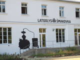 |
Завод шмаковки Малнавской усадьбы (1827) предлагает посетителям экскурсию, дегустацию, закуски. Осмотр усадьбы, парка, бункеров Гитлера, туристическая информация о достопримечательностях Латгалии. |
|
 |
В хозяйстве выращивают коноплю и предлагают познакомиться с историей этого растения, его использованием в рационе и в бане. Здесь производят конопляное масло и молоко. Экскурсия, приобретение произведенной продукции. |
|
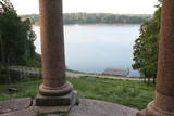 |
These are beautiful and impressive views, particularly early in the morning, of the historical locations of Alūksne. Go to Templis Hill, the Aleksandrs Pavilion, the obelisk which commemorates Heinrich von Fittinghoff, and the memorial to soldiers of the No. 7 Sigulda Brigade for good views. The Templis Hill, the castle ruins, the estate and the pavilions are arhitectural monuments.
|
|
 |
This is a cemetery that was originated in the Middle Ages and used until the beginning of the 20th century. A mossy stone fence surrounds the cemetery. Interesting elements in the cemetery include the grave of Heinrihs Jakobsons (1832-1911), who was the first schoolteacher in Mazirbe (the old metal cross is to the left of the main gate), a pine tree of national importance and has a circumference of 3.17 metres (during the Soviet Union someone drilled a hole in the trunk of the tree to access honey), the grave of Niks Freimanis (1845-1908), who is said to have been the prototype for a character in a story and play by Marģers Zariņš, and the Werewolf Grave, which relates to countless ghost stories, including the claim that it is the only known gravesite of a werewolf in Latvia. |
|
 |
Штаб зенитноракетной бригады и связистов использовался для обеспечения военной радиосвязи, планирования и координации. Сейчас объект практически не используется и передан Латвийскому центру репартации и Христианской миссии.
|
|
 |
«Яунпилс пиенотава» работает уже более ста лет (с 1912-го года) и сырных дел мастера здесь производят полутвердые сыры, мягкие сыры, творог, сметану, десерты и другие молочные продукты. В процессе производства используют только молоко, произведенное латвийскими крестьянами. Продукция экспортируется в более чем 17 стран мира. Продукцию предприятия «Яунпилс пиенотава» можно купить в находящемся рядом с предприятием магазине. |
|
 |
Augstrozes pilskalna taka atrodas ainaviskā vietā, gleznainā 13. gadsimta pilskalnā, kas apvīts ar teikām un leģendām. No pils drupām paveras labākais skats uz lielisko ainavu, ko veido Augstrozes Lielezers un Ziemeļu purvi.
|
|
 |
~ 3 – 5 km gara taka, kas ved pa veco ceļu gar Tēramā upes (Tõramaa jõgi) kreiso krastu. Takas malās izvietoti interaktīvi elementi bērniem, kas palīdz labāk uztvert dabā notiekošo. Taku ieskauj mitrie meži un palieņu pļavas, kas palu laikā atrodas zem ūdens. Tēramā (Tõramaa) ciemā apkārtnē atrastas cilvēka darbības pēdas jau no akmens laikmeta. |
|


