
| No | Name | Description |
|---|---|---|
 8 days
|
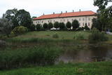
This tour offers a look at modern farms that based their work on ancient jobs and skills. Everything that is grown and processed in Latvia's countryside is found at the Central Market in Rīga, where this tour begins. It is one of the largest and oldest markets in Europe. From there you will travel to several farms to taste candy made of natural juices, cheese, grain foods, yogurt and ice cream. You will visit a traditional farm with a technology museum. Each farm will offer a brief introductory tour. Along the way, you will visit the Rundāle Castle and its park and rose garden, which were designed by the 18th century architect Rastrelli and are a true jewel of Baroque and Rococo architecture. In Bauska you will visit City Hall to see a collection of old measuring items, the Bauska Castle and the Bauska brewery. In Lithuania you will visit farms that grow lavender, medicinal plants and hemp. They will be happy to sell their products to you. The town of Anykščiai offers a trail above the trees, and the Krenave archaeological complex is on the UNESCO heritage list. At the conclusion of the tour, you will visit the Trakai lake castle that was built in the 14th and 15th centuries, as well as Vilnius. |
|
 |
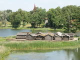
An ancient Latgalian settlement. During the 10th century Kraslava district was under authority of the Prince of Polotsk, but the 13th century - under the authority of the Livonian Order. Until the beginning of 18th century it existed as a manor centre. In 1729 Kraslava was bought for 1400 thalers by Johan Ludvig Plater. Plater family ruled Kraslava for two centuries. In the of the18th century Platers began construction of Krāslava palace. After first division of Poland in 1772 Latgale was annexed to Russia. Kraslava began to perish. After construction of Riga - Daugavpils - Vitebsk railway (1865) economic life flourished again. Kraslava was little affected by the World War II, therefore, early wooden buildings of 20th century remained almost untouched. |
|
 |
In a document from 1387, the village is named Minor Irva. Until the mid-20th century, Mazirbe was the largest Livonian village on the coast of Kurzeme. It was a fishing village and a centre for fishing. The village had a church, school, pharmacy, forestry company, several stores, a post and telegraph office, train station, barber shop, bakery and photo workshop, as well as a brick kiln. During the 1930s, a local fishing co-operative built a fish processing plant here. The Livonian Association was established here in 1923, and the Livonian People's Centre was opened in 1939. Oppoite the centre is the Stūrīši homestead (the home of the Taizel dynasty), where you can learn about everyday household objects and, by ordering it advance, taste local foods. The first chairmen of the Livonian Association, Kārlis Stalte and Māritņš Lepste, lived in Mazirbe. Cultural worker Kārlis Stalte (1870-1978) spent man years as the verger and organist of a church in Mazirbe. Mārtiņš Lepste was a Livonian language teacher in the 1930s. The former Maritime School building can be viewed from the outside. Some 2,000 students attended the school between 1894 and 1914. During Soviet years, the army had a base here. |
|
 |
A relaxed café in Ādaži with a terrace that offers a wide panorama over the banks of the River Vējupe and is the perfect spot for enjoying beautiful sunsets. Modern world cuisine with salads, snacks, soups, rich main courses, burgers, and soft drinks. |
|
 |
Atrodas 0,9 km no Jaunpiebalgas muižas pils, Jaunpiebalgas centra virzienā. Redzot šo ēku, nav jāpārliecina, ka tā ir viena no garākajām Vidzemē. Tik gara, ka grūti pat „iedabūt kadrā”. |
|
 |
One of the largest castles in Kurzeme, this building has been preserved in fairly good shape. Work on its began in the mid-13th century, and it was commissioned by the heads of the Dome Cathedral in Rīga. In 1434, the estate was bought by the bishop of Kurzeme. The Maidel and Osten-Sacken dynasties owned it from the 16th to the 20th century. The Dundaga Castle burned down twice and has been rebuilt many times. The last reconstruction was in 1905, after the castle was burned down during the revolution. Of interest on both sides of the castle’s door are stone carvings of a knight and a bishop. In recent years, the hotel in the castle has been renovated, as has the second floor hallway and a terrace that is popular for weddings. There are many legends about the castle, including one about a wedding of elves and another about the Green Lady. Today the building houses the Dundaga School of Music and Art, a hotel, party rooms, the Dundaga Tourism Information Centre and various exhibitions. It is worth finding a guide to tour the castle. Groups of tourists can also order tastings of local foods. |
|
 |
One of the 15 semi-estates of the former Dundaga Castle, Vecmuiža, has a private collection of historical materials. |
|
 |
The tavern and pastry shop is located near the Vidzeme highway, by the natural trails of Cecīļi and Ieriķi. Tourist Information Centre is also nearby. We offer traditional dishes and our specialities |
|
 |
The Lake Castle of Āraiši is of pan-European importance. It is a reconstructed Lettigalian lake castle from the 9th or 10th century, and it is the only place in the Baltic States at which visitors can learn about how people lived more than 1,000 years ago. The castle offers various thematic events. |
|
 |
This is the most impressive and colourful set of cliffs along the Vidzeme coastline. Waves have created the steep shore that is as much as 6 m high, with several hundred meters of red sandstone cliffs with narrow caves, niches, grottos and other formations. The nearby Veczemu farm is where the Rīga Film Studio shot the films “Long Way into the Dunes” and “The Nest of the Old Fisherman.”
|
|
 |
Legendary restaurant Halinga is located on the roadside of Via Baltica half an hour’s drive from Pärnu in the direction of Tallinn. The restaurant is suitable for both busy travellers and organising events, including for large groups. We use as many local ingredients as possible and cook according to local recipes. |
|
 |
Ātrās apkalpošanas kafejnīcas ar plašu ēdienu sortimentu visas dienas garumā. Sortimentā iekļauti latviešu nacionālie ēdieni, kā arī citu tautu ēdieni. Izbraukuma banketi, dažādu viesību mielasti, semināru apkalpošana, sporta spēļu un sporta nometņu ēdināšana. |
|
 3 days
|
Druskininkai tradicionāli ir bijusi kūrortpilsēta - tā piedāvā mežu, Nemunas krastu un ezeru ieskautu mūsdienīgu SPA viesnīcu kompleksu un ūdens atrakciju parku, kā arī plašu gājēju un veloceliņu tīklu. Turpat netālu atrodas iekštelpu slēpošanas kalns "Snoras Snow Arena", kurš ir pirmais un vienīgais ziemas izklaides centrs Baltijas valstīs un darbojas visu gadu.
|
|
 |
Kihnu farm offers traditional Kihnu island dishes from home-grown vegetables and local fish. |
|
 5 days
|
Путь пролегает по красивейшему ландшафту Балтии – через Национальные парки Гауя, Лахемаа и Матсалу, Видземскую возвышенность, а также возвышенности Отепя и Пандивере. Также в маршрут включены Мунамегис, Чудское озеро и селения по его берегам, каменистое морское побережье в Северной Эстонии, самые живописные водопады Эстонии, рыбацкие поселки. Вы увидите природные тропы, смотровые вышки и самые великолепные поместья и дворцы. Возможно дополнительно организовать сплав на лодке по рекам Ахья и Выханду. |
|
 |
The café is in the centre of Aglona on the edge of the Dagda road (P60). |
|
 |
Mud ponds for regeneration are used by
the spa and the rehabilitation centre. The mud
is purified from biological additives over the
course of a longer period of time, after which it
can once again be used for the famous
treatments offered at Ķemeri.
|
|
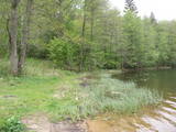 |
The most important aspect of the Sasaļi forest is the eutrophic Lake Sasalis, as well as the unusual Lake Melnezers. Also of importance are various types of forestland in the area. Lake Sasalis is a popular place for leisure and swimming.
|
|
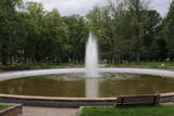 |
Mūsdienās redzamais parks starp Rīgas un Parādes ielu tapa vairāk nekā pirms 100 gadiem un tā patrons bija pilsētas pirmais mērs - Pāvels Dubrovins (1839. – 1890.). Pilsētas „zaļā saliņa”, kuras centrā atrodas strūklaka, ir iecienīta atpūtas un pastaigu vieta. Atraktīvs ir no bronzas veidotais piemineklis (2007. g., tēlnieks A. Tartinovs),kas veltīts pilsētas pirmajam mēram. |
|
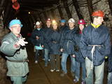 |
Gas mixture is the main raw material for Estonia’s energy and chemical industries, and it is extracted in our day from open quarries or underground shafts. This layer was established during the Ordovician Period between 450 and 480 million years ago, and it is made up of the remnants of plants and animals from that age. In the Kohtla-Nõmme suburb, there is a shaft which can be toured in the company of a guide who will tell you that this is the only layer of its kind in the Baltic States. He will tell you about how the gas mixture has been extracted over the course of history.
|
|


