
| Nr | Name | Beschreibung |
|---|---|---|
 |
This park is found in the Otepää highlands and offers an outstanding example of how the terrain of a protected natural territory can be used for recreation, sports and active leisure. The infrastructure of the park is perfect for such activities and is of a high level of quality.
|
|
 |
1,8 km garā taka atrodas neparastā vietā – uz Cirīša ezera salas. Tās galvenās vērtības ir augu valsts un dzeņveidīgo putnu daudzveidība. Viens no apskates objektiem ir Upurkalns – sens pilskalns. Taka labiekārtota, izveidoti informācijas stendi, atpūtas vieta. Lai nokļūtu uz salas, no vietējiem jānomā laiva, vai jādodas ar savējo. Atrodas dabas parkā „Cirīša ezers”. |
|
|
|
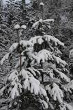
Tītuvēnu reģionālais parks (Tytuvėnų regioninis parkas) dibināts 1992. gadā. Parkam raksturīga ainavu daudzveidība – te ir sastopami lieli mežu masīvi, purvi, ezeri, upītes. Šejienes reljefa veidotājs tāpat kā citur Baltijas valstīs ir bijis ledājs, kas atnesis un atstājis aiz sevis garas laukakmeņu grēdas. Kopumā parkā ir konstatētas 603 augu un 787 dzīvnieku sugas. Parkā aug veci un dabiski boreālie (ziemeļu) meži, veci un jaukti platlapju meži ar ozoliem, liepām, kļavām, ošiem un gobām, sugām bagāti egļu meži, staignāju meži, nogāžu un gravu meži, purvaini meži un aluviālie (pārplūstošie) meži. Parkā esošās pļavas un tīrumi ir nozīmīga dzērvju atpūtas vieta migrāciju laikā, kad te pulcējās tūkstošiem putnu. Šiluvas baznīca un Tītuvēnu klosteris ir svētceļnieku galamērķis vairāk nekā 500 gadu garumā. |
|
 |
Es wurden sechs Standpunkte mit Informationsständen gestaltet, auf denen der See, der Wald, die Wiese, die Dünen und das Moor (Aussichtsturm) vorgestellt und die Prozesse in der Natur dargestellt werden.
|
|
 |
Umfasst das Tal des größten Flusses Litauens Nemunas zwischen den Siedlungen Seredžiaus und Geldaudišķis mit malerischen Blicken auf Burgberge, mittelalterliche Burge und Landgüter. |
|
 |
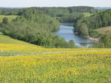
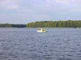
The most important aspects of this park are a shallow lagoon-type lake – Lake Pape, with its flood land meadows, the shore of the Baltic Sea, the Nida swamp, and the more than 270 different types of birds that have been spotted here. The oldest bird ringing station in Latvia (est. 1966) is found between Lake Pape and the Baltic Sea. Birds and bats are caught and ringed there. Lake Pape is the first place in Latvia where so-called “wild” horses (the “Konik” breed) were released with the aim of managing the flood land meadows.
|
|
 |
This is a small area with lots of different terrains – high hillocks, distinct river valleys, thermal streams, continental dunes, etc.
|
|
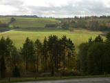 |
As you travel from Kandava to Sabile, you will find a parking lot on the right side of the road. From there, there are steps to a viewing area on the highest hill in the Abava Ancient River Valley – Greiļi Hill. This offers a wonderful view of the ancient river valley and the local mosaic of meadows and forests. The landscape is enriched by the Imula and Amula valleys that are on the other side of the ancient river valley.
|
|
 |
Der Tērvete Naturpark befindet sich in einem Gebiet, das nicht besonders typisch für die Zemgale Region ist – im Tērvete - Flusstal. An seinen Ufern gibt es riesige Wälder, die sich gut für Freizeitaktivitäten eignen. Es gibt Naturdenkmäler und auch hervorragende Kultur- und Geschichtsdenkmäler in dieser Gegend. Der Tērvete Landschaftspark ist einer der beliebtesten touristischen Ziele in Zemgale. Die Besucher finden hier einen Wald mit uralten Kiefern, einen herrlichen Landschaftspark, das Sprīdīši-Arboretum, die Burgberge von Tērvete, Klosterkalns and Svētkalns, das Museum “Sprīdīši”, das der großartigen lettischen Autorin Anna Brigadere gewidmet ist, verschiedene Kinderattraktionen, schöne Landschaften, ein enges Netz von Wanderpfaden usw. Dieser Naturpark ist 2004 zum familienfreundlichsten Ort in Lettland ernannt worden.
|
|
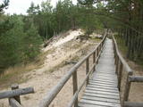 |
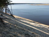
Abwechslungsreicher Pfad, der über einen Holzsteg entlang des Steilufers der Pilsupe bis zur Weißen Düne führt, die sich in der Zeit des Litorina Meeres vor einigen tausend Jahren gebildet hat. In der Umgebung wurden Überreste steinzeitlicher Siedlungen gefunden.
|
|
 |
Der ökologische Gletschermuldenpfad und der Waldpfad im Naturpark von Embūte (nur in Begleitung eines Führers) erläutern die gletschergeformten Hügel und Schluchten von Embūte (die Schluchten mit den Böschungswäldern sind geschützte Biotope). Burgberg, Herrenhäuser, Schloss und Kirchenruine von Embūte, der Sterbeort des Oberhauptes der Kuren - Indulis, Teufelsberg, Wiesen und Aussichtsturm. Der Pfad befindet sich im Naturpark Embūte.
|
|
 |
Dieser Park befindet sich im ausgeprägtesten Teil der Dagda-Hügel des Latgale-Hochlandes. Teil davon ist der tiefste See der Baltischen Staaten – der See Drīdzis, der 63,1 m tief ist und neun Inseln hat. Dort befindet sich ebenfalls der See Otis. Den hübschesten Blick hat man vom alten letgallischen Burgberg, der als Sauleskalns-Berg bekannt ist und vom Ostufer des Sees Drīdzis. Unterkünfte gibt es in der Nähe des Sees.
|
|
 |
Established: 1931. The arboretum was set up at the suggestion of Latvia’s distinguished author Anna Brigadere. After her death and until 1935, the arboretum was supported and expanded by book publisher Jānis Rapa. There are some 180 foreign trees and shrubs of various kinds here. Some of the plants are outside the arboretum itself.
Unique plants: The Bunge’s Ash (Fraxinus chinensis), the Eastern Black Walnut (Juglans nigra), the American Buckeye (Aesculus glabra), the Smoketree (Cotinus coggyria), the White Mulberry (Morus Alba), and the Kentucky Yellowwood (Cladrastis kentukea).
|
|
 |
Das ist ein flacher, lagunenartiger See, der mit dem ihn umgebenden Feuchtgebiet von internationaler Bedeutung ist. 271 Vogelarten wurden in diesem Gebiet gezählt, einschließlich 43 Vogelarten, die in der Lettischen Roten Liste aufgeführt sind und 15 aus der Europäischen Roten Liste. Zum Park gehören das Nida-Moor und der Teil des Meeres, das sich längsseits des Parks befindet. Zwischen dem Pape-See und der Ostsee befindet sich Lettlands älteste Vogelberingungsstation, wo nicht nur Vögel beringt werden, sondern auch Fledermäuse. Der Pape-See ist das erste Territorium in Lettland, wo Rückzüchtungen von Wildtieren ausgewildert wurden, um die überschwemmten Wiesen des Sees sachgerecht verwalten zu können. Zuerst waren es Wildpferde (Konik-Pferde), dann Auerochsen und der europäische Bison. Durch den Pape-See führt auch Lettlands einzige markierte Wassertourismusroute. Besucher können Vogel- und Naturbeobachtungstürme nutzen, Naturpfade usw. Das Dorf Ķoņi ist ein einzigartiges Beispiel für ein am Meer gelegenes Fischerdorf. Der Pape-See ist unter den Vogelbeobachtern beliebt. Das Besucherzentrum wurde im “Haus der Natur “ des WWF eingerichtet.
|
|
 |
Dieser Naturpark schützt die Landschaften des Latgale-Hochlandes. Von Bedeutung sind die Seen Ruskulis und Cīrītis mit ihren acht Inseln, zusammen mit den Wäldern dieses Gebietes. Ein alter Burgberg befindet sich auf einer der Inseln im See Cīrītis – die Upursala-Insel. Dort und auf der Oši – Insel haben Spezialisten mehr als 250 Pflanzenarten gefunden.
|
|
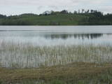 |
Dieser Park wurde eingerichtet, um die Burzava Hügel, den See Adamova (ein eutrophischer See) und die Biotope und Arten, die man entlang seiner Ufer - einschließlich der Fledermäuse - findet, zu schützen. Den schönsten Blick über das Gebiet hat man von den Hügeln des Nordufers des Sees. Hier gibt es Unterkünfte an den Ufern des Adamova-Sees, wo Touristen die Nacht verbringen können.
|
|
|
|
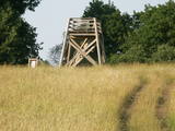
The viewing tower is on the western part of the Blue Hills of Ogre, not far from the Dubkalni quarry. Paths lead to the tower, as does a wooden staircase. The viewing platform offers a very broad view of the Ķegums hydroelectric power plant reservoir and the towers of
|
|
 |
Ein wichtiger Komplex an Küstenlinie und Sanddünen entlang der Mündungen der drei Flüsse – Lielupe, Daugava und Gauja. Diese Gegend hat sehr alte Traditionen für Erholung und Kurbetrieb. Das Gebiet hat eine wunderschöne Küstenlandschaft und weist eine der wenigen Küstenwiesen von Lettland auf. Der Park umfaßt auch einige geschützte Areale – die Wiesen der Lielupe – Mündung, Vakarbuļļi, Daugavgrīva, Vecdaugava und Ummis (siehe Abteilung “Geschützte Naturareale”). Interessante Naturelemente in dieser Gegend sind das Amphitheater der Garciems – Dünen, zusammen mit einzelnen Dünen wie der Legzdiņi – Düne und der sogenannten Skiberg – Düne. Besucher werden durch verschiedene Kulturdenkmäler angezogen - den Befestigungsanlagen auf der Mangali – Insel, Militärbauten aus der russischen Zarenzeit bis zum Ende der sowjetischen Okkupation, der Festung von Daugavgrīvak, dem Vecāķi Kurbad mit seinen alten Küstenbauten und den Stränden von Daugavgrīva und Vecāķi. Die Nähe zur Stadt Riga und die verschiedenen wichtigen Erholungseinrichtungen sind der Grund für die vielen Erholungssuchenden in diesem Gebiet. Der Naturpark ist für aktiven Tourismus geeignet (wandern, Rad und Boot fahren, Autosport), Langlaufski, Natur- und Vogelbeobachtung, Kulturtourismus, passiver Freizeit- und Bildungstourismus. Es gibt Naturpfade in den Daugavgrīva- und den Rožu-Dünen zusammen mit anderen Einrichtungen der Infrastruktur.
|
|
 |
This territory was established to protect the lovely central section of the Neries River, local species, and Lithuania’s largest oak forest.
|
|
 |
Ap 25 km gara un līdz 1,5 m plata vaļņveida reljefa forma Adzeles pacēluma dienvidu malā, kas apaugusi ar skujkoku mežu. Latvijā reti biotopi un nozīmīga daudzu aizsargājamu augu un dzīvnieku sugu dzīves vieta. Numerenes valni var ļoti labi "izjust", braucot pa Kārsavas - Tilžas ceļu. Dabas parkā atrodas slēpošanas kalns "Nūmerene".
|
|


