
| Nr | Name | Beschreibung |
|---|---|---|
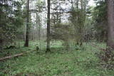 |
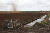
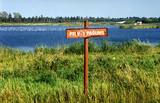
One of the rare places (see also Rucavas ivju audze) in Latvia where two rare and protected wild tree species grow - yew-tree and Baltic ivy. Territory is not marked on site with information signs or stands. Territory is not suitable for visitors as visitor without environmental knowledge will see “regular” forest. On the East side of the restricted area is located extending low wall – former narrow gauge railway (600 mm, length 41 km) line Dulbeni – Rucava. Railway was built by German military forces with the goal – to export wood.
|
|
 |
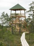
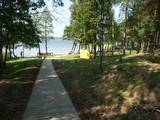
The tower is beyond the Oleri estate, in the small Oleri swamp, where at the end of a wooden footpath you can step upward a bit and learn about the landscape of a transitional swamp. This is part of the ZBR.
|
|
 |
Dabas liegums atrodas dienvidaustrumos no Lubāna ezera un tas veidots purva un meža biotopu un tajos esošo sugu aizsardzībai. Gar teritorijas ziemeļu robežu iet Nagļu - Degumnieku ceļš (iekļaujas kopējā Lubāna dambju sistēmā), pa kuru apkārt Lubāna ezeram izveidots velomaršruts. Tas nozīmē, ka teritoriju var aplūkot arī "no malas", netraucējot tās dabiskās norises. Teritorija ietilpst arī Lubāna mitrāja kompleksā.
|
|
 |
Der Zilais – Berg (Blaue Berg) ist die höchste Erhebung im Idumeja – Hochland, es ist ein sehr ausgeprägter, mit Wald bedeckter Hügel. Von hier aus kann man die “nahe” Landschaft sehen, die den nördlichen Teil des Hochlandes darstellt und das Burtnieks – Flachland. Das Territorium wurde eingerichtet, um die Habitate, wie zum Beispiel die Schluchten, die Hügel und den Nördlichen Nadelwaldgürtel in diesem Gebiet zu schützen. Der Zilais – Berg ist ein beliebtes touristisches Ziel.
|
|
 |
This is part of a hiking trail along the Cena bog. It is on the western side of the bog, at the centre of the 5-kilometre circular trail. You can see the vast swamp, as well as a military road that was installed during World War I and is marked by an “alley” of large pine trees. Alongside the tower is a fragment of the road that was installed more recently.
|
|
 |
Das ist ein langgestrecktes Gebiet zwischen der Ostsee und der Straße Kolka – Ventpils. Es beginnt an der Mündung des Flusses Irbe und endet in Ovīšrags. Das Territorium wurde vor allem eingerichtet, um den trockenen Koniferenwald, die Graudünen, Feuchtbegiete zwischen den Dünen, andere Landschaftserscheinungen, Pflanzen und Tiere in dem Gebiet zu schützen. Touristen lieben die sandigen und ruhigen Strände in dieser Gegend, die Leuchttürme von Miķeļbāka und Ovīši und die lutherische Kirche in Miķeļbāka. Hier gibt es auch noch einige Hinterlassenschaften des sowjetischen Militärsystems, die nicht touristisch genutzt werden.
|
|
 |
Līčiem, pussalām un salām bagāts ezers ar izrobotu krasta līniju, kas savienots ar Zvejnieku un tālāk - citiem Latgales augstienes ezeriem. Ozolu un platlapju meži, kas aug uz ezera salām un pussalās ir ne tikai aizsargājami, bet arī Latvijas mērogā nozīmīgi biotopi. Tiesa, to vērtību apzināsies tikai vides speciālisti. No Jašas ezera var uzsākt laivu braucienu pa vienu no Latgales ezeru "kēdēm". Ezera austrumu krastā atrodas Geļenovas parks.
|
|
 |
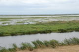
After a big storm in 2005, the nature trail of the Randu meadows was restored. It is about 4 km long, and there is a bird-watching tower which offers a fine view of unique shoreline meadows with small lagoons and areas of reeds. It is a fine place to watch migrating birds. This is part of the Northern Vidzeme Biosphere Reserve (ZBR).
|
|
 |
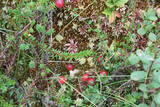
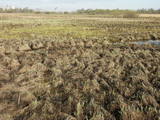
Nature restricted area is established to protect various wetland habitats – Big Kirba Bog and protected plant species within it. Only the West part of the Bog is a protected nature area. The rest of the bog is used mainly for intensive extraction of peat and large cranberry cultivation. Nature restricted area of the bog has no tourism infrastructure therefore is not useable for tourist visits.
|
|
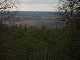 |
This is an area that is full of legend and tale. There is a stiff hillock, which stands about 66 metres above the surrounding land. From its southern side, you can see the Burtnieki lowlands. The tower, however, is not open to the public.
|
|
 |
Regelmäßig werden die Auenwiesen am Ost- und Südufer des Sees Burtnieks überflutet, sie sind ein wichtiger Nistplatz für den selten gesehenen Wachtelkönig. Ein Natur- und Informationspfad wurde in Vīsrag eingerichtet mit Richtungsangaben, Informationsständen und einem Aussichtsturm.
|
|
 |
The territory has been established for protection of the bog and its habitat species. It is not appropriate for visits. North-east part of the bog can be slightly seen from the road Neveja – Lapmezciems on winter season. Further on Cirste direction is located on of most impressive oak trees in Latvia – Rigzemju ozols.
|
|
 |
Das ist eine ungewöhnliche Landschaft mit einem geschützten Biotop – der Binnendüne mit Silbergraswiesen und Wäldern mit Laubbäumen, einschließlich der Hainbuche. Touristen können den heiligen Fluss Muiža (Lejas) am rechten Ufer des Sventāja – Tales besuchen . Hier werden sie Lettlands prächtigste Traubenkirschbäume finden. Eine Pergola aus Blättern hat sich über dem Fluß gebildet.
|
|
 |
Dort befindet sich ein kleines Gebiet auf der Westseite des Sees Būšnieks, das eingerichtet wurde, um den Sumpfbiotop und die seltenen Pflanzen zu schützen. Gut ausgestattete Erholungseinrichtungen befinden sich am gegenüberliegenden Ufer des Sees.
|
|
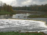 |
The recently renovated old brick bridge and the viewing area that is on the left bank of the Venta beyond the castle guard’s hut offers a lovely view of the widest and most impressive waterfall in Latvia – the Venta falls. It is worth visiting during the spring floods, when fish are migrating.
|
|
 |
Natürliche Auenwiesen entlang der Ufer der Lielupe vor Jelgava. Viele geschützte Pflanzen findet man hier, Vögel nisten und rasten hier während des Vogelzugs.
|
|
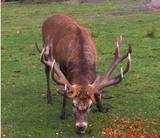 |
he wetland meadows that are around the Pededze River are the site of this 200 ha farm with some 350 red deer, other deer and wild boar. There are towers from which you can watch the graceful animals, and there are ponds for commercial fishing. Please contact the owner well in advance for a tour. |
|
|
|
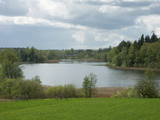
Atrodas Zebrus ezera austrumu krastā pie Latvijas Valsts mežu laivu bāzes. No torņa labi pārskatāms Zebrus ezers, ziemeļu virzienā – Ezerlūķu pilskalns. Laivu bāzē – atpūtas vietas. |
|
 |
Dieses Territorium schützt den eutrophischen See Istra und die entlang zu findenden Biotope – verschiene Wald- und Wiesenarten. Dies ist eine besonders schöne Gegend von Latgale. Interessanterweise kann das sogenannte “schnurförmige” Anordungssystem der Felder noch im Naturpark besichtigt werden.
|
|
 |
Dieses grüne Sumpfgrasland ist ein Gebiet zwischen Dünen, das von Zeit zu Zeit überschwemmt wird, es ist ein wichtiger Ort für geschützte Pflanzen. Dieser Sumpf kann gut von den bewaldeten Dünen, die auf der südöstlichen Seite des Sumpfes stehen, betrachtet werden.
|
|


