
| Nr | Name | Beschreibung |
|---|---|---|
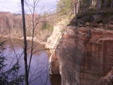 |
The viewing area on the Ērgļi (Ērģeles) cliffs offers an impressive view of Latvia’s most monolith sandstone cliffs (up to 22 metres high) – this is the highest location in the Gauja River valley. Please be very careful and don’t go anywhere near the edge of the cliff!
|
|
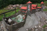 |
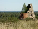
In diese konnte man über eine Zugbrücke gelangen, in dem man die äußere und die innere Vorburg durchquerte. Bis in die Mitte des 16. Jh. diente die Burg als Residenz des Komturs von Dünaburg. 1577 wurde sie vom Heer Iwans des Schrecklichen zerstört.Nach diesem Ereignis verlor Dünaburg seine strategische Bedeutung und der Bau eines Festungsbaus wurde dort begonnen, wo sich heute Daugavpils befindet. Neben der Ruine der Ordensburg befindet sich ein verkleinertes Modell der Burg, damit man sich vorstellen kann, wie es hier vor vielen Jahrhunderten ausgesehen hat. Vom Parkplatz bis zum Burghügel gelangt man über einen bequemen Pfad.Vom Burgberg hat man einen der schönsten Ausblicke auf den Naturpark der Daugavabiegungen. |
|
 |
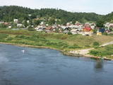
The loveliest views of the local cultural and historical treasures (the Āraiši lake castle, the Lutheran church, the parsonage, Medieval castle ruins – all of these cultural monuments). The hillocks of the area which offers this view can be found in the immediate proximity of the Āraiši windmill and the Drabeši-Āraiši road.
|
|
 |
A beautiful part of the Rēzekne-Dagda-Krāslava road – along two km or so, you can see Lake Rāzna and Mākoņkalns hill, which is 10 km away on the other shore of the lake. |
|
 |
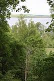
The impressive Gauja River valley and its best natural and cultural landscapes can be seen from Paradīze (Gleznotāji) Hill, the Sigulda castle ruins, the aerial tram, the Ferris wheel, the Ziediņi and Pilsēta ski trails, the area of the bobsled and sledding trail, Ķeizarskats, the viewing area of the Velnala cliffs, the mountain bike route of Sigulda (on the right bank of the Gauja, particularly when the trees are bare), the area of the Krimulda castle ruins, Dainu Hill, and the Turaida castle tower.
|
|
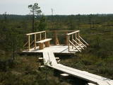 |
At the end of a wooden footpath in the Planči swamp is a viewing area and place for leisure. This is the place where you can enjoy landscapes of the high-type swamp and breathe the unusual air of the swamp. This is the only outdoor infrastructure object in Latvia with information posted in Braille. It is in the ZBR.
|
|
 |
Aptuveni 0,5 km dienvidos no Mežotnes pilskalna atrodas Vīna kalns, kas līdzīgi kā Mežotnes pilskalns, ir veidots, izmantojot Lielupes ielejas stāvās krastu nogāzes, tās pārveidojot. Vietvārds ir it kā radies no stāsta, ka šeit parādījies dievgalds ar maizi un vīnu. Vīna kalnu ar Mežotnes pilskalnu savieno jauka koka laipa, kas ved pa Lielupes ielejas pamatkrasta lejas daļu. |
|
 |
The Mežotne castle hill is on the left bank of the Lielupe River and opposite the Mežotne Castle. This was one of the largest Semigalian fortified castle hills during the 9th to the 13th century, and an ancient town alongside the hill covered 13 ha of land. The castle hill has been improved. A pontoon bridge across the Lielupe allows hikers and bikers to reach the castle (between May and October). Vīna Hill is approximately 500 m to the South of the castle hill, and a wooden pathway leads to it. |
|
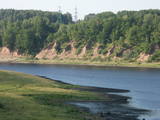 |
In Aizkraukle, drive down Enerģētiķu Street to the Selonian side (there will be small “pockets” at the side of the road) to see one of the best views of the Daugava River valley, reminding us of what this fateful river was like before the power plant was built. You will see that the river has eroded the steep cliffs on the right bank. The further part of the valley is part of the Daugava Nature Park.
|
|
 |
The Northern breakwater of Liepāja is located n the Karosta area of the town. It offers a lovely place for perambulations, as well as an opportunity to observe the sea. To the South of the breakwater you will find a fine view of the Liepāja Freeport and its system of breakwaters. To the East is the unique Karosta area, while to the North, there are remnants of a sea fort. Please be very careful while observing the sea, however – the surface of the breakwater is not in great shape.
|
|
 |
A new section of the walking trail along the sea has been built and an environmental object "Sunset watcher" has been created in Saulkrasti near the White Dune and Sunset Trail. It is a photo object where the newlyweds and every guest of Saulkrasti can capture memories in the symbol of the sun, which is so characteristic of Saulkrasti. |
|
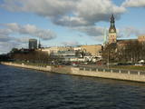 |
The classical skyline of Old Rīga can be enjoyed from several locations – Mūkusalas Street, between the railroad bridge and the stone bridge, from the stone bridge, from the A-B dam, from the grounds of the central office of the Swedbank bank, from the Vanšu bridge, and from the Ballast Dam at Ķīpsala. You can hike or bike from location to location. During the summer, little ships cruise up and down the Daugava to offer different views.
|
|
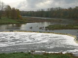 |
The recently renovated old brick bridge and the viewing area that is on the left bank of the Venta beyond the castle guard’s hut offers a lovely view of the widest and most impressive waterfall in Latvia – the Venta falls. It is worth visiting during the spring floods, when fish are migrating.
|
|
 |
The area known as the territory of high hillocks has several heights – Lakta Hill (250 metres above sea level), Egļu Hill (268 metres above sea level), and Bākūži Hill (272 metres above sea level). They are connected by an earthen road – it’s worth hiking the trail to find the best viewing areas. A very fine view of the backs of hillocks in the Vidzeme highlands can be seen from the northern side of Lakta Hill.
|
|
 |
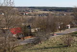
An all-encompassing view of the urban environment next to the Daugava River valley is offered at the car park which is at the start of Augusta Street on the boundary of Krāslava. The unique wooden buildings of the area (the Kaplava Street region) can also be seen on the bridge which crosses the Daugava. Climb Karņickis Hill and hike through the park of the Plāters family of nobles. From there, you will see more local scenes.
|
|
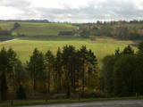 |
As you travel from Kandava to Sabile, you will find a parking lot on the right side of the road. From there, there are steps to a viewing area on the highest hill in the Abava Ancient River Valley – Greiļi Hill. This offers a wonderful view of the ancient river valley and the local mosaic of meadows and forests. The landscape is enriched by the Imula and Amula valleys that are on the other side of the ancient river valley.
|
|
 |
At the estuary of the Inčupe River, there is the White Dune, which is around 18 metres high and is the most lovely element of the Vidzeme shoreline among those that have been created by the wind, sand and sea. There is a wooden footpath (the Saulriets trail) which is meant to view, but also protect the dune. It has a viewing area, too. The territory to the south of the river is in the Piejūra Nature Park.
|
|
 |
This is not a well known castle hill, but it offers one of the most unusual views of Lake Lielezers of Augstroze. There are ruins on the castle hill, and a short hiking trail has been installed to look at them. This is part of the ZBR.
|
|
 |
We recommend that you walk through the town of Kandava not only to enjoy the charm of a small town, but also to find fantastic viewing locations where you can see the town and the shores of the ancient Abava River valley from the Kurši (Ancestor) castle hill, Lielā Street, the Bruņinieki castle hill and Zīļu Street (School Hill), as well as from the area of the Ozolāji open-air stage.
|
|
 |
In the centre of Līgatne, on the right bank on the rapid Līgatne River, there is a viewing plan which offers a close-up look at one of the most impressive sandstone cliffs which rise above it – the Lustūzis cliff. There are artificial caves in the wall of the cliff, which locals use as cellars and as places to store their property.
|
|
