
| Nr | Name | Beschreibung |
|---|---|---|
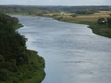 |
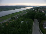
Eine schöne malerische Flussstrecke zwischen Alytus und Pakuoni, wo der Fluss mehrere breite Mäanderkrümmungen mit bis zu 40 m hohen Mörenenabdeckungen macht (Balbieriškio-Abdeckung u.a.). |
|
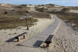 |
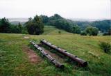
Die Dünen nördlich Pervalka über dem ehemaligen Dorf Negeln. Eine 9 km lange Strecke mit den wüstenartigen Landschaften. Stegpfade. |
|
 |
Ein Gebiet zwischen Palanga und Klaipeda, gegründet für den Schutz der Dünen und Biotopen der Küstenwälder. Ein asphaltierter Radweg läuft durch das Gebiet. |
|
 |
Der erste Nationalpark Litauens. Gegründet für den Schutz der Landschaften und der Seen der Aukštaitija-Anhöhe, der etnographischen Dörfer und der Naturvielwalt. |
|
 |
Kauņas jūras reģionālais parks (Kauno marių regioninis parkas) dibināts 1992. gadā. Tas ietver Nemunas HES uzpludināto posmu – lielāko Lietuvas ūdenskrātuvi no Kauņas līdz Piļonas (Piliuona) ciemam. Viena no nozīmīgākajām parka vērtībām ir ainava, kas veidojusies ilgā cilvēka un dabas mijiedarbībā. Parkā konstatētas 950 augu sugas, 600 dzīvnieku, t.sk. - 34 zivju sugas. Parka nozīmīgas dabas vērtības ir meži, augstie purvi, kadiķu audze. Parkā ir apskatāmi dažādu vēsturisko periodu liecinieki – senču pilskalni, Pažaislis klosteris, Kauņas cietokšņa Piektais forts, kā arī Rumšišķes (Rumšiškės) brīvdabas muzejs – viens no lielākajiem (195 ha) šāda veida muzejiem Eiropā. Vaišvīdavā (Vaišvydava) ir izveidots parka apmeklētāju centrs, parkā ir dabas takas, piemēram, Žiegždriai ģeoloģiskā taka un Dubravos izziņas taka. |
|
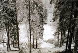 |
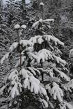
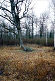
Ein mit Wäldern und Seen reiches Gebiet im Nordteil der Dzūkija-Anhöhe. Das Täufelsbeet (Velnio duobė) ist eine bis 40 m tiefe und 200 m breite trichterförmige Grube, die Entstehung der mit einer Tätigkeit eines urzeitlichen Gletschers verbunden ist. |
|
 |
Nemunas bildet sich bei der Mündung ins Haff ein einzigartiges Gebiet mit Mooren, alten Flußarmen, Lagunenseen, Flußauen und der Rusnė-Insel, das ein bedeutender Erholungsplatz für Zugvögel ist. Im Frühling stehen große Fläsche unter Wasser. |
|
|
|
Tītuvēnu reģionālais parks (Tytuvėnų regioninis parkas) dibināts 1992. gadā. Parkam raksturīga ainavu daudzveidība – te ir sastopami lieli mežu masīvi, purvi, ezeri, upītes. Šejienes reljefa veidotājs tāpat kā citur Baltijas valstīs ir bijis ledājs, kas atnesis un atstājis aiz sevis garas laukakmeņu grēdas. Kopumā parkā ir konstatētas 603 augu un 787 dzīvnieku sugas. Parkā aug veci un dabiski boreālie (ziemeļu) meži, veci un jaukti platlapju meži ar ozoliem, liepām, kļavām, ošiem un gobām, sugām bagāti egļu meži, staignāju meži, nogāžu un gravu meži, purvaini meži un aluviālie (pārplūstošie) meži. Parkā esošās pļavas un tīrumi ir nozīmīga dzērvju atpūtas vieta migrāciju laikā, kad te pulcējās tūkstošiem putnu. Šiluvas baznīca un Tītuvēnu klosteris ir svētceļnieku galamērķis vairāk nekā 500 gadu garumā. |
|
 |
This is a small area with lots of different terrains – high hillocks, distinct river valleys, thermal streams, continental dunes, etc.
|
|
 |
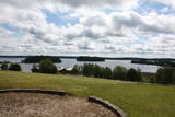
There are three large lakes at the centre of this park – Lake Dusia, Lake Metelys, and Lake Obelija. Lake Dusia has very clear and transparent water, and its southern and south-eastern beaches are popular among swimmers. The lakes and their nearby wetlands are important during the migration season of birds.
|
|
 |
In the central part of the Žemaitija Highland, this park was established to protect local landscapes. Lithuania’s highest hillocks are found here – Mėdvegalis (235 m above sea level) and Šatrija (229 m). There are also other hillocks which offer a great view of the area – make up your own tour here.
|
|
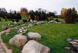 |
The terrain in this territory was created during the Ice Age. There are the ancient river valleys of the Minija, Salantas and Erla rivers, along with groups of rocks.
|
|
 |
Žagarė ist schon von Alters her berühmt für seine Kirschen, die „Žagar-Kirsche“ („Žagarvyšnė“). Davon gibt es mehrere Varianten, die sich nach Reifezeit, Ertrag, Baumform und anderen Eigenschaften unterscheiden. Bis zum heutigen Tag wachsen solche Kirschen nahezu in jedem Hof, was diese gewissermaßen zu einem Symbol der Stadt macht |
|
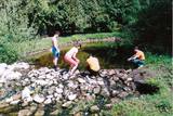 |
This is one of the most outstanding areas in the entire Baltic States with active underground waterways which still, to this very day, dissolve local gypsum rock. Parts of the area collapse regularly, and there are legends about all of this. Underwater rivers, streams, the so-called Karvės (Cow) cave, etc., can be seen in the area.
|
|
 |
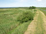
The park was established to protect the Venta River valley and the landscapes that are around its tributaries. On the west bank of the Venta, at Papilė, there is a cliff from the Jurassic period which is unique in the Baltic States, has been known since 1925, and has layers in which more than 300 forms of life have been identified over the course of time.
|
|
|
|
Gegründet für den Schutz der Landschaften und der Seen der Aukštaitija-Anhöhe, Arten und Biotope. |
|
 |
The “backbone” to this park is the valley of the Šventoji (Holy) River. One of the most impressive Devonian cliffs in Lithuania can be seen from the river – Vetygalos atodanga. On the shores of the Varius stream is a cliff made of quartz and sand – Variaus atodanga. 6 km to the S of Anykščiai is Lithuania’s second largest rock (5.7 m high, ~100 m3) – Puntukas akmuo.
|
|
 |
This park is located in the northern part of the Žemaitija Highlands, and much of it is taken up by Lake Plateliai. The park was established to protect lakes, rivers, wetlands and forest ecosystems, as well as the local cultural environment.
|
|
 |
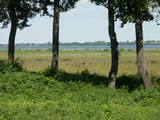
This territory was established to protect the lovely central section of the Neries River, local species, and Lithuania’s largest oak forest.
|
|
 |
Umfasst das Tal des größten Flusses Litauens Nemunas zwischen den Siedlungen Seredžiaus und Geldaudišķis mit malerischen Blicken auf Burgberge, mittelalterliche Burge und Landgüter. |
|

