
| Nr | Name | Beschreibung |
|---|---|---|
 |
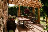
Das Café befindet sich im Zentrum von Saldus. Lettische Küche: Sauerkrautsuppe, Suppe mit Fleischbällchen, Rote-Beete-Suppe, Ampfersuppe, kalte Kefirsuppe, Kartoffelpfannkuchen, dünne Pfannkuchen, geschmorte Schweinerippen, hausgemachte Frikadellen, Gastmahl des Bauers, Haferflockencreme, geschichtetes Haferflocken- oder Roggenbrot-Dessert. |
|
 |
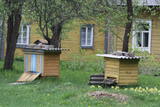
Der Hof bietet seinen Gästen Führungen durch die Brauerei des Gutes Butautai, Fahrradtouren, Spaß im Wasser und Angeln im Fluss Levuo sowie Gerichte mit Hopfen. |
|
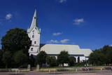 |
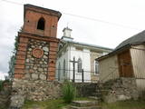
Atrodas pilsētas centrā - Tirgus laukuma malā. Dievnams tapis 1495. g., pēc Livonijas ordeņa mestra Valtera fon Pletenberga (~ 1450. – 1535.) pavēles. Gadsimtiem ritot, ēka pārbūvēta un tagad redzamais tornis celts 1907. g. Baznīcā apskatāmi nozīmīgi kultūrvēstures pieminekļi: altārglezna “Golgāta” - H. Kīperta darināta kopija (pēc K. Arnoldi Kandavas luterāņu baznīcas oriģināla (1864. g.)), muižniekam Fīlipam Drahenfelsam veltīta epitāfija (B. Bodekers, 16. un 17. gs. mija), A. D. Tīzenhauzenas kapu plāksne (1648. g.), kristāmtrauka pamatne (18. gs.) un piemiņas plāksne 1. pasaules karā un Latvijas Brīvības cīņās kritušajiem draudzes locekļiem (1925. g.). Ap Tirgus laukumu (atjaunots, jauka strūklaka) izvietojies Dobeles vēsturiskais centrs. |
|
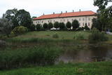 |
One of the largest castles in Kurzeme, this building has been preserved in fairly good shape. Work on its began in the mid-13th century, and it was commissioned by the heads of the Dome Cathedral in Rīga. In 1434, the estate was bought by the bishop of Kurzeme. The Maidel and Osten-Sacken dynasties owned it from the 16th to the 20th century. The Dundaga Castle burned down twice and has been rebuilt many times. The last reconstruction was in 1905, after the castle was burned down during the revolution. Of interest on both sides of the castle’s door are stone carvings of a knight and a bishop. In recent years, the hotel in the castle has been renovated, as has the second floor hallway and a terrace that is popular for weddings. There are many legends about the castle, including one about a wedding of elves and another about the Green Lady. Today the building houses the Dundaga School of Music and Art, a hotel, party rooms, the Dundaga Tourism Information Centre and various exhibitions. It is worth finding a guide to tour the castle. Groups of tourists can also order tastings of local foods. |
|
 2 Tagen
|
Die Route ist für aktive Fußgänger geeignet, die auf ihrer Reise sowohl Landschaften, als auch die Gefühle des Tales des eindrucksvollsten Flusses der baltischen Länder genießen möchten. Die Route beginnt in Sigulda, die historisch als die Schweiz der Region Kurzeme genannt wurde. In der Umgebung von Sigulda kann man einige der schönsten Landschaften Lettlands genießen. Die Route überquert mehrere tiefe Täler der Nebenflüsse von Gauja und legt die Ufer des Flusses frei, die im Baltikum mit seinen Sandsteinfelsen der Devonperiode bekannt sind. Die Naturpfade von Līgatne ist der einzige Ort in Lettland, wo in waldiger Umgebung, unter naturnahen Umständen und in großen Pferchen unseren Wäldern charakteristische Tierarten wohnen, die Besucher besichtigen können. Aber Tiere und ihre Fußabdrücke kann man auch besichtigen, wenn man auf den Naturpfaden und in den Wäldern des Nationalparks Gauja wandert. Route information from Latvijas Lauku forums |
|
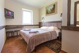 |
Viesu nams "Igne" ir vieta, kur palikt uz vienu nakti vai apmesties uz ilgāku laiku. Tā atrodas netālu Druskininkai Jaskoniai ciematā, tikai 4 km attālumā no pilsētas centra, taču tā ir klusa vieta prom no pilsētas burzma. Iespēja uzņemt līdz 50 cilvēkiem istabās ar labierīcībām. Apmeklētāju ērtībai augstas klases restorāns "Romnesa", omulīga sauna, bezmaksas autostāvvieta un bezvadu internets. Piemērota vieta konferencēm, semināriem, privātiem un korporatīviem pasākumiem. Tiek piedāvātas izglītojošas meistarklases šakotis gatavošanā, Šakotis muzeja apskate. |
|
 |
Ja mērķis ir savākt pilnvērtīgu etnogrāfisko ciemu fotokolekciju, ir jāapskata Strazdi (no lietuviešu valodas strazdai tulkojumā nozīmē strazds), kas ir pavisam neliela apdzīvota vieta Balošas (Baluošas) ezera ziemeļu krastā. Strazdi pirmoreiz rakstos minēti 1783. g. un ciema nosaukums cēlies no kādas mežziņu dzimtas uzvārda. |
|
 |
Einer der ausgeprägten Kaps der lettischen Küste mit Niederungsauen und einem in 1875 gebauten Leuchtturm. |
|
 8 Tagen
|
Diese Tour führt von Rīga bis nach Tallinn und kombiniert Naturerbe mit Kulturerbe. Die Tour umfasst anziehende Landschaften und 15 Naturpfade, die durch Moorländer, Wiesen und Wälder an der Küste der Ostsee, sowie durch einige Naturschutzgebiete führen. Auf vielen Pfaden sind Vogelbeobachtungstürme eingerichtet. In den Küstenwiesen Randi in der Nähe von Ainaži wächst ein Drittel aller Pflanzenarten von Lettland. Auf einem Steg, der durch Schilflandschaft führt, kann man zu einer Aussichtsplattform gelangen, von der man die Wiese und die Ostsee besichtigen kann. Die Insel Saaremaa ist im Vergleich zum Festland mit ihren verschiedenen Naturattraktionen interessant: Dolomitenfelsen, Wacholdern, einem Meteoritensee und mit ihrer felsigen Küste. Die Tour führt durch Bauernhöfe und traditionelle Fischerdörfer in der Küstenregion. Die Insel Hiiumaa ist ein ruhiger Ort mit einer estnischen Atmosphäre – mit einem wichtigen Vogelschutzgebiet in der Kaina Bucht, dem ungewöhnlichen, natürlichen Wellenbrecher Saare Tirp, sowie mit einigen kleinen Inseln auf der südöstlichen Seite der Insel. Zurück auf dem Festland. Die Halbinsel Paldiski gibt mit ihrem ehemaligen Militärstützpunkt eine Einsicht in die sowjetische Geschichte, die nicht so lange zurückliegt. |
|
 |
Die GmbH "Skrīveru saldumi" ist ein Süßigkeitenhersteller, die das berühmte Konfekt "Skrīveru Gotiņa" herstellen. Sie haben eine "Süßigkeitenwerkstatt” eröffnet, wo Besucher die Möglichkeit haben selbst an der „Gotiņas” Expedition teilzunehmen und selbst das eigene Konfekt einzuwickeln, die Geschichte der Erstehung vom Betrieb kennenzulernen, die Produktion zu kosten, sowie frische, natürliche Süßigkeiten direkt vom Werk zu kaufen. Es werden fünf verschiedene Besuchsprogramme angeboten!
|
|
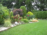 |
You will feel the beauty, power and energy of nature here, ensuring harmony with nature and a good sense of the energy of rocks, plants, Latvian plants and underground streams. Rocks here decorate the garden, which offers a good view of the sea and a cascade of waterfalls that are delightful in the spring and the fall. During the summer, it is a rock river. The site is one km to the north of the bus stop in Tūja and has 28 types of coniferous trees, 14 decorative shrubs, 13 kinds of rhododendrons, and winter plants. The interesting collection of stones may mean that there is an energy field, and the garden is quite esoteric. The rocky seashore of Vidzeme is nearby, and the garden has received many prizes from the Salacgrīva Administrative District and Latvia as such. |
|
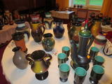 |
Die Inhaber erzählen und zeigen, wie aus Ton die verschiedenen Erzeugnisse entstehen. Die Besucher können sich auch selbst beim Töpfern versuchen. Vorrätige Produkte kann man erwerben oder auch neue bestellen. |
|
 |
Touristisches Zentrum Avinurme Puiduait ist vor allem das Zuhause für feine Holzbearbeitung in Avinurme. Gerade hier gibt es die reichste Auswahl von Späneprodukten, viele Saunaprodukte und Gebrauchsgegenstände aus Holz. Gäste haben die Möglichkeit an verschiedenen Workshops teilzunehmen: Korbflechten, Filzen, Brotbacken, Kerzengiessen, Gummistiefel-Malen u.a. Avinurme Puiduait ist ein Tourismuszentrum, in dem man die örtlichen Holzerzeugnisse anschauen kann. Hier gibt es auch ein Café, in dem Speisen aus der Peipussee-Umgebung angeboten werden, die auf den Holzerzeugnissen serviert werden. Außerdem kann man hier auch selbstgebackenes Roggenbrot kaufen. Das Laden bietet eine große Auswahl an Holzerzeugnissen. |
|
 |
Mājas restorāns mājīgā, autentiskā lauku vidē, kur tiek pasniegti lauku ēdieni, uz galda celtas svaigas jūras veltes, kuras atceļojušas no Francijas, Spānijas vai Norvēģijas, kā arī vietējās, pašu saimnieku kūpinātas zivis. Ēdienkarte tiek radīta katru dienu no jauna, kas ikdienā ļauj piedāvāt svaigus produktus.
|
|
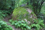 |
200 m attālumā no Gulbenes – Madonas ceļa mežainā nogāzē iegūlis 2,4 m augstais akmens. Tā lēzenajā virsmā iekalta ap metru gara, 0,3 m plata un ap 4 cm dziļa iedobe, bet akmens šķautnē - pakāpieni. Uzskata, ka šis ir sens kultakmens, pie kura ziedots. Lai nokļūtu līdz akmenim, vasaras otrajā pusē var nākties brist pa garu zāli. |
|
 |
Dieser Ort befindet sich am nordöstlichen Ufer des Sees Razna. Die Wirtin bietet lettgallische Gerichte, interaktive Lehrveranstaltungen für die Erkundung der Umwelt und Dienstleistungen des Reiseleiters an. Lettische Küche: Gerichte aus Süßwasserfischen: Geräucherte Fische, Schleien in Sauerrahmsoße, im Öl gebratene Barschen, im Ofen gebackene Brachse, gefüllter Hecht und andere Gerichte, die aus lokalen Produkten vorbereitet werden. Das besondere Gericht: Auf offenem Feuer gekochte Suppe aus den Fischen aus dem See Razna. |
|
 |
Daugavpils – Krāslavas (A 6) ceļa malā redzamais dievnams uzcelts ar Plāteru dzimtas pārstāvju – Vaclava un Kazimira Plātera atbalstu 1811. gadā. Dievnamu ieskauj metālkaluma un no ķieģeļiem mūrēts žogs, kā arī divi zvanu torņi. Labās puses zvanu tornī karājas vecs zvans. No baznīcas iekārtas ir jāpiemin galvenais altāris, ko rotā Dievmātes skulptūra, trīs biktskrēsli, četras evaņģēlistu sienas freskas un Lurdas Dievmātes glezna. Ikdienā apskatāma no ārpuses. |
|
|
|
Atrodas Ostas ielas rietumu galā. No laukakmeņiem veltīto kompozīciju uzstādīja 1938. g. (idejas autors – bijušais Ventspils ostas kapteinis V. Ābelnieks) un tā ir piemiņa visiem zvejniekiem un jūrniekiem, kuriem atdusas vieta ir jūras dzelme. |
|
 |
Heutzutage ist die ehemalige Meldegängerabteilung der UdSSR in Wälder von Bārta ein Privateigentum und das Objekt wird abgebaut.
|
|
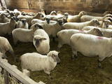 |
Auf den Feldern der Wirtschaft weiden mehr als 150 Schafe. Hier ist eine Station zur Mästung von Zuchtböcken gebaut worden. Hier werden Tierauktionen und Schaftage organisiert. Der Wirt leitet Führungen und bietet Zuchtschafe und Schafproduktion zum Verkauf. |
|


