
| Nr | Name | Beschreibung |
|---|---|---|
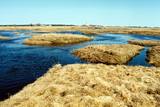 |
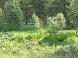
This is one of Estonia’s most beautiful karst fields, covering 125 hectares which feature different karst processes – subterranean streams, the dry Jõelähtme River bed, karst streams, funnels, ditches, caves, cliffs, a unique rock “mushroom,” etc. During the spring, the field is flooded, but at other times of the year, its contents are easily visible.
|
|
 |
Die Grabstätte der Mondtochter (Ida Apsāne) kann man auf dem alten evangelisch-lutherischen Friedhof von Laši (0,2 km nördlich von der evangelisch-lutherischen Kirche von Laši) finden. Auf dem Grabdenkmal von Ida Apsāne ist dieser Text zu lesen: „Ida Marie Apsahn dzim. 23 März 1867 mir. 10 April 1887.” Auf dem Friedhof von Laši sind auch andere ihre Familienmitglieder beigesetzt worden. |
|
 |
Atrodas Īvandes dienviddaļā, Vankas upītes krastos. Ūdensdzirnavas celtas 1842. gadā (par to liecina arī sienā iemūrēts dzirnakmens) un darbojas joprojām. To iekārtas ir saglabājušās no 1930. gada. Divstāvu ēka apskatāma no ārpuses, bet iepriekš piesakoties, - arī no iekšpuses. |
|
 2 Tagen
|
Маршрут предусмотрен для путешественников, которых привлекает большой и частый перепад рельефа, а также для тех, кто жаждет увидеть и на себе испытать впечатляющие берега глубокой древней долины Аматы, передвигаясь по мало тронутым лесным тропам. Тропа, проложенная на правом берегу реки, петляет как по нижней, так и по верхней части долины, поэтому местами необходимо преодолевать перепад высоты более чем 40 метров. Maršruta informācija no Latvijas Lauku foruma |
|
 |
The territory has been established for protection of the bog and its habitat species. It is not appropriate for visits. North-east part of the bog can be slightly seen from the road Neveja – Lapmezciems on winter season. Further on Cirste direction is located on of most impressive oak trees in Latvia – Rigzemju ozols.
|
|
 |
This pyramid-shaped hillock with an observation tower at the top of it was established by the Soviet military. It is along the Ķevele-Saldus road, where the Zvārde airfield used to be located. It was used as an observation facility to co-ordinate army training manoeuvres. There is a view of the former airfield and the massive forests of the Zvārde Nature Park and nature reserve. It is an appropriate location for bird-watching. Note that there are no improvements there.
|
|
 |
Četrus kilometrus garā lokveida un marķētā dabas taka meklējama Plateļu pilsētiņas ziemeļaustrumu daļā. Tā ved pa dažādiem biotopiem – mežu, purvu, ezera malu, atklājot dažādas ainavas un tajās mītošās augu, putnu un dzīvnieku sugas. Šī ir interesantākā un ainaviskākā no Žemaitijas nacionālā parka takām. |
|
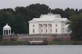 |
Das heute gesehene Ensemble (im Stil des Neorenaissance gebautes Gutshaus) entstand im wesentlichen in der Zeit zwischen 1897 – 1902 als ein Eigentum vom Grafen Joseph Tyszkiewicz und seiner Frau. Ein Park. |
|
 |
Der „Hof der lauten Stille“ befindet sich am Hang zum Ufer eines Altarms des Nevėžys. Hier werden „glückliche Nahrungsmittel“ hergestellt, ausschließlich aus dem, was auf dem eigenen Hof erzeugt wird. |
|
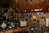 |
Diese Ausstellung ist in Bukupe (Bezirk Saldus, Gemeinde Zirņi) auf dem Bauernhof Ziķi zu finden. Man kann die vom Besitzer des Hofes Andris Bušinskis gesammelten Ausstellungsgegenstände aus dem Bereich Kino und Foto anschauen. Zur Sammlung gehören alte Kinoeinrichtungen und Gegenstände, die den Prozess des Fotografierens und der Kinoaufnahme darstellen. Die Ausstellungsgegenstände sind in einem vom Besitzer errichteten Holzblockhaus in Form von Bienenwaben untergebracht. Nach vorheriger Anmeldung! |
|
 |
This is the ancient shore of the Baltic Ice Lake. We can only imagine the landscape 10,000 years ago, when the Kurzeme peninsula was covered with vegetation reminiscent of a tundra, and waves from the icy lake dashed against the ancient shoreline. We know that the lake was full of icebergs of various sizes. Today the cliff is more than 20 km long (some 9 km of it are in the Slītere National Park), and it is as much as 42 m high. It is the most impressive cliff of its type in all of Latvia. At the foot of the cliff are the Irve flatlands (the name comes from the Liv 'īrva' or 'īra', both of which refer to deer). The flatlands are the former bottom of the Baltic Ice Lake. The Blue Hills are crossed by many small streams and rivers (Pitragupe, Lorumupe, Kaļķupe, Mazupe, etc.). Their valleys are the basis for a branched and very complicated system of waterways which look particularly impressive when the trees are bare. In many places the cliffs and valleys display small areas of sandstone from the Narva suite. These are Latvia's oldest sediment cliffs that can be seen above ground. Although the Blue Hills are very impressive in scope, there are only a few places where there are important viewing areas (a viewing tower at the Dundaga-Mazirbe road, the view from the Šlītere lighthouse, the view from Mežlīdumi). The mightiness of the ancient shoreline can truly be enjoyed from the Cirste-Mazirbe road, the Cirste-Riepaldi road, Mežlīdumi and the Vīdala-Melnsils road). It is worth visiting the area in the springtime, when the slopes of the Blue Hills seem to be sinking under the fresh greenery. |
|
 |
Local History Museum of Nautrēni. Permanent exposition of the
local history of the district, school and parish.
Working hours: on request |
|
 |
Umfasst das Tal des größten Flusses Litauens Nemunas zwischen den Siedlungen Seredžiaus und Geldaudišķis mit malerischen Blicken auf Burgberge, mittelalterliche Burge und Landgüter. |
|
 |
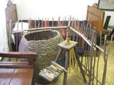
In the workshop it is possible to learn about the process of creating and the usage of pottery of different historic periods, as well as other household goods. Archaeological pottery is presented. The Middle Ages man-carried clay bread oven, frying-pan, drinking cups, the pilgrims’ water bowls. All the works are handmade in the moulded ceramics style and burned in the clay kiln. |
|
 |
This farm has some 150 hives of bees which are carefully tended by beekeepers. The farm also produces nectar plats such as buckwheat, clover and phacelia. You will learn all about beekeeping and taste and purchase beekeeping products. |
|
 |
Das Wort grinis verweist sich auf einen in Lettland sehr ungewöhnlichen Waldtyp. Es gibt zwei Typen – den Heidekrauttyp und den Grastyp. Das ist das Ergebnis einer langandauernden Wechselwirkung zwischen Natur und Mensch. Solche Gebiete findet man nur an wenigen Stellen an der Küste der Ostsee. Eine sehr seltene Pflanze, die in diesem Gebiet wächst - die Glockenheide - war der Hauptgrund, warum hier ein Naturreservat 1936 errichtet wurde. Eine stillgelegte Eisenbahnlinie zwischen Ventspils und Liepāja führt durch dieses Reservat von Norden nach Süden. Besuche des Reservats sind streng verboten.
|
|
 |
An der rechten Uferbiegung an der Mündung der Inčupe erhebt sich die bis zu 18 m hohe weiße Düne, die malerischste Ausgestaltung von Wind, Sand und Meer an der Küste der Rigaer Bucht - ein alter Orientierungspunkt der Seefahrer. Ein Stegpfad mit Aussichtsplattform. Das Gebiet südlich von Inčupe liegt im Naturpark Piejūra.
|
|
 1 Tag
|
Guided wilderness experience day-trip combines bog shoeing and canoeing. First is walking through the forest and reaching the largest peat-bog in Estonia – Kuresoo. Wear bogshoes and walk on the wild landscape, followed by wilderness lunch. The trip ends with a relaxing canoe trip along Soomaa meandering rivers. |
|
|
|
Taka, kas izveidota Lemmjegi (Lemmjõgi) un Raudnas (Raudna jõgi) satekas vietā, iepazīstina ar palieņu pļavām un veciem pārmitriem mežiem, kas ir vieni no lielākajiem Igaunijā. Takas sākumā dominē atklātas lauku ainavas. Viens no 4,9 km garās lokveida takas apskates objektiem ir Lemjē dižozols. Mitrā laikā noderēs ūdensizturīgi apavi. |
|
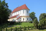 |
The Skaistkalne Roman Catholic Church is in the southern part of Skaistkalne and on the right bank of the Mēmele River valley. The Baroque church is known as the most beautiful Catholic church in Zemgale. The ornate interior and the graves of clergymen and noblemen can be toured. |
|


