
| Nr | Name | Beschreibung |
|---|---|---|
 |
In der Bäckerei werden mehr als 50 verschiedene Arten von Backwaren angeboten. Das Konformitätszertifikat „Zaļā karotīte" („Grüner Löffel“) wurde für das Roggenbrot „Arona" vergeben. Mit "Bordo karotīte" („Bordeauxroter Löffel“) zertifizierte Produkte – Roggenbrot, süß–saures Brot, Latgale–Kastenbrot, gewelltes Weißbrot, Roggen–Klonbrot, Cesvaine–Klonbrot, Madona–süß–saures–Brot, Birži–süß–saures–Brot. Die Bäckerei hat mehrmals Medaillen auf der Messe „Riga Food" erhalten. |
|
 7 Tagen
|
Этот маршрут предлагает вам отличную возможность посетить самый большой остров Эстонии – Сааремаа, который является своеобразным символом для туризма по Эстонии. На острове находятся один из наиболее впечатляющих метеоритных кратеров в Северной Европе, Епископский замок Курессааре, самая крутая отвесная скала в Эстонии и множество других интересных туристических объектов. |
|
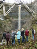 |
This is a cliff with various levels. Known as the North Estonian cliff, it stretches all along the shore of the Bay of Rīga in Estonia, including some of the local islands. The most expressive part in geological and landscape terms is the Saka-Ontika-Toila cliff, which is around 22 km long and offers an unusual natural environment. The cliff is as much as 53 m high, and it has a fairly virginal forest along its slopes. The layers of clay, sandstone, limestone, etc., come from the Cambrian and Ordovician periods. The Valaste juga (Valaste waterfall) is 24 metres high. After a longer period of freezing temperatures, the waterfall has a particularly impressive appearance. Seasonal waterfalls (8-10 m) can be found near the villages of Ontika and Toila.
|
|
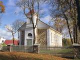 |
St. John the Baptist Roman Catholic Church of Nagļi was built
in 1862 by landlord Nābels. Some time ago, Nagļi Church was a branch of Viļāni Church. The Bernardian
monks served there. After the closing of the cloisters in 1930s, the church was served by priests.
|
|
 |
Der Name von Dobele ist in den historischen Quellen im Jahr 1254 erwähnt worden. Dobele war einer der am besten befestigten Orte der Semgallen, darum hat dieser Ort von 1279 bis 1289 sechs Einfälle der Kreuzritter überlebt. Doch im Jahr 1289 waren die Semgallen gezwungen zurückzutreten. Im Jahr 1335 haben die Eroberer an der Stelle der Burg von Semgallen mit dem Bau einer neuen – gemauerten Burg begonnen. Am gegenüberliegenden – am linken Ufer des Flusses Bērze begann sich eine Ortschaft der Händler und Handwerker zu bilden. Die Stadt hat sehr stark im Nordischen Krieg und in der darauf folgenden Pestzeit gelitten. Ein bedeutendes Ereignis im wirtschaftlichen Leben der Stadt war das Jahr 1927, als die Eisenbahnlinie Liepāja – Glūda ausgebaut wurde. Nach dem Ersten Weltkrieg kamen nach Dobele Militärpersonen der Sowjetarmee, die einen der größten Panzerschießplätze der UdSSR Dobele-2 gebaut haben. Jetzt können die Besucher von Dobele interessante Sehenswürdigkeiten besichtigen. |
|
 |
Ein herforragender Sandsteinfelsen am rechten Ufer des Flusses Gauja mit Blick aufs Urstromtal von Gauja und einen Naturpfad. Erholungs- und Feuerplatz. |
|
 |
The workshop and “Dream Hut” exhibition hall at this venue offer a look at turned wood products such as candelabras, dishware, beer steins, vases, glasses, mortars and pestles, small boxes, wooden paintings, etc. You can commission and purchase products and watch the master at work. |
|
 |
They work together since 1996. The members are knitting woollen socks, mittens, scarfs, sweaters, embroider sofa cushions, blankets, table cloths, paint on scarfs and ties, weaves blankets, towels, carpets, bookmarks, crochet toys, clothing, blankets as well as creates wickerwork and wooden ware, they demonstrate the baking process of traditional Latvian sklandrauši and tea making. The knitters from the organisation created the traditional mittens for the NATO summit guests in Riga. The visitors can view the different products, learn different crafts, bake sklandrauši and make different tea mixes themselves. They also offer excursions in the renovated Ance’s manor castle. |
|
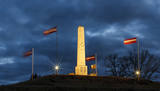 |
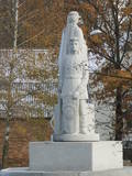
Befindet sich auf einer Anhöhe, an einem schönen Ort, am Ufer des Alūksne Sees bei der Pleskavas Straße (P 40). Das Denkmal wurde am 20. Juni 1923 vom Staatspräsident Jānis Čakste eröffnet. Das Denkmal wurde nach einem Entwurf des Bildhauers J. Miesnieks errichtet. Im Zentrum des Denkmals ist ein Schild mit einem gekreuzten Schwert dargestellt. Auf dem Sockel ist die Inschrift angebracht: “Den für Lettland gefallenen Kriegern des 7. Infanterieregiments von Sigulda. 1919 – 1920”. Auf einer anderen Seite ist folgende Inschrift angebracht: “Besser sein Leben geben, als unser Vaterland verlieren”. In der Sowjetzeit (1953) wurde das Denkmal abgerissen. Das Denkmal wurde 2009 erneuert. |
|
 |
(V-1279) linked Kuldīga and Alsunga before a new road was built. The lovely gravel road weaves through forests and farmland. During appropriate weather, it can be used as an alternative road to learn about the landscapes of the Suiti region. You can also bike down the road. |
|
|
|
Eine der drei Anhöhen im Südestland mit malerischen Hügeln und schönen Aussichtsplätzen. Im „Zentrum” der Anhöne legt sich der mit Buchten reiche Pühajärv See (Heiliger See). |
|
 |
Diese Gaststäte liegt an einem landschaftlich sehr schönen Ort – im Urstromtal des Flusses Abava, zwischen Kandava und Sabile. Die Gaststätte befindet sich in einem historischen Gebäude mit einem Mantelschornstein, der einer der größten im Baltikum ist. Nebenan befindet sich eine Erholungsstätte für Wassertouristen. Lettische Küche: Kalte Rote-Beete-Suppe, Suppe aus Fleischbällchen, Ampfersuppe, Sauerkrautsuppe, Hähnchenleber, hausgemachte Frikadellen, geräucherte Schweinerippen, gebratenes oder gegrilltes Schweinefleisch, Kartoffelpfannkuchen mit Sauerrahm, dünne Pfannkuchen, Kräutertees. Das besondere Gericht: Mit geräuchertem Fleisch, Quark und Zwiebeln gefüllte Klöße. |
|
 |
The owners are in the process of renewing a more than a hundred-year-old wooden barn, where they plan to organize creative workshops for young people, with the participation of a blacksmith, carpenter and other craftsmen. The owner teaches how to plat a paling. There is a possibility to get to know farm animals – rabbits, chickens, ducks, goats, etc. The house of useful arts is going to be opened in May 2014 |
|
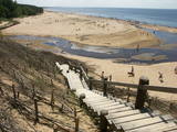 |
The White Dune is one of the landmarks of Saulkrasti, on the Vidzeme gulf coast. The dune offers a splendid view of the sea, the mouth of the Inčupe River and the vast beach. The White Dune formed as the wind drove beach sand over the clay silt of Baltic Ice Lake. Its white 18 meters high sand outcrop once helped local fishermen find their way home. The dune got its name from its white, hardened layers of sand which look like sandstone. |
|
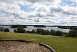 |
This park is located in the northern part of the Žemaitija Highlands, and much of it is taken up by Lake Plateliai. The park was established to protect lakes, rivers, wetlands and forest ecosystems, as well as the local cultural environment.
|
|
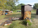 |
On the second Saturday of each month (or at other times that are arranged in advance), the owner will allow you to test your skills at smoking fish, after which you will be able to taste what you have produced. |
|
 |
Das Gasthof Pinska ist ein Familienunternehmen, das sich auf dem Grundstück des ehemaligen Landguts Lõpinska befindet. Das Essen wird mit den örtlichen Produkten und nach den örtlichen Traditionen zubereitet. |
|
|
|
On 14 June 1991, this sign sculpted by Zezostrs Ķēde in memory of the repressions of 1941 and 1949 was unveiled in the garden of Pēterupe Church. |
|
 |
Izcila lokveida taka (4,5 km), kuras lielākā daļa (koka laipas) ved pa Rīsas purvu (Riisa raba). No takas un divstāvīgā koka skatu torņa ir vērojami purva ezeriņi, lāmas, un purvaini meži. Ja nacionālā parka apskati sāk no ziemeļu puses, tad šī taka ir labs ceļojuma iesākums! |
|
 2 Tagen
|
Маршрут подходит для активных туристов, интересующихся многообразием природной и культурной среды национального парка «Кемери». Национальный парк «Кемери» (основан в 1997 г.) создан, прежде всего, для защиты водноболотных угодий – мелководного побережья Рижского залива, заросших прибрежных озер, болот, влажных лесов (трясин и др.) и пойменных лугов, как значимых мест произростания многих растений (~ 25 % от видов растений, занесенных в Красную книгу Латвии) и обитания животных, особенно мест скопления гнездящихся и перелетных птиц. На территории парка находится один из крупнейших заболоченных массивов Латвии – Большое Кемерское болото. Заболоченные массивы являются значимым местом образования и выхода сероводородных вод, а также местонахождения лечебных грязей, используемых в медицине, которые в свое время послужили основанием для создания известного курорта «Кемери». Информация о маршруте от Latvijas Lauku forums |
|


