
| Нo | Название | Описание |
|---|---|---|
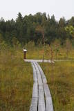 |
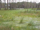
The small Andrupene swamp is found to the North of the Andrupene Farm Museum in a deep area between hillocks. It is a high-type swamp with an open central part, and it is 130 m long and 120 m wide. There are stands of white alder alongside the swamp. In 2009, the administrators of the Rāzna National Park restored a wooden educational pathway that had been established originally by the Andrupene Elementary School. Today there are stairs, a viewing platform, wooden pathways, and information stands. |
|
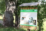 |
Interesanta dabas izziņas taka, kurā izvietoti informatīvie stendi, kas stāsta par dažādiem pļavu biotopiem – sausām, palieņu un parkveida ozolu pļavām un tās iemītniekiem. Pļavas nogana dzīvei savvaļā pielāgotie mājlopi. |
|
 |
The main goal of the Vestiena protected landscape area is to protect the landscape values in the Vidzeme highlands. The protected area is in the middle of the Vidzeme highlands with the highest and most prominent relief, including Gaiziņkalns, the highest spot in the country. The many lakes found in the area - Viešūrs, Talejas, Kāls, Pulgosnis and others – not only add to the variety of the landscape, but also offer tourism and recreation options. The Vestiena protected landscape area encloses several other especially protected/Natura2000 sites – the Gaiziņkalna nature park, the island of the lake Kāla, the lake Ilziņa restricted natural area. Among the most interesting tourist attractions are the Vestiena estate, the Piekūnu wandering trails, the Gaiziņkalna nature trail. The area is rich in landscapes, however, there are no viewing spots or towers installed to observe the landscape. On the top of the Gaiziņkalns, the Latvia’s highest spot, there still stands the wreck of the former viewing tower.
|
|
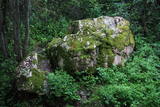 |
Līdz akmenim aizved (ir norādes) skaista taka, kas līkumo pa Rogāļu strauta izrauto gravu. Strauta kreisā krasta nogāzē, ~ 0,1 km pirms tā ietekas Daugavā, iegūlis 6,5 m garais, 4,6 m platais un līdz 3,7 m augstais Rogāļu akmens, kura tilpums ir novērtēts ap 40 m³. Blakus tam atrodas liela atlūza. |
|
 |
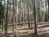
The Ķemeri National Park was established in 1997 and mostly involves wetlands – the shallow shores of the Bay of Rīga, an overgrown seaside lake, vast swamps, damp forests and fens, and flood-land meadows. The park is enormously important for protecting plants (25% of those recorded in Latvia’s Red Book are found in the park) and animals, particularly nesting and migrating birds. The Great Ķemeri Bog is one of the largest swamps in Latvia, and there are other swamps, as well – the Zaļais swamp and the Raganu swamp. The massive swamps are important, too, in the flow of sulphuric waters and medicinal mud. The once-famous Ķemeri Spa was based on the availability of these resources. Most of the cultural and historical objects in the Ķemeri National Park relate to the seashore as a place for leisure and recuperation. Educational nature trails, bicycle trails, hiking trails, bird-watching towers and other facilities are available. The visitors centre is at the recently renovated “Forest House” in Ķemeri. |
|
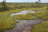 |
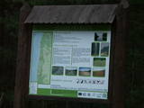
Very wide territory for a nature restricted area where extensive forests and several bogs can be found. The territory is important living space for many bird species. Vasenieku bog path with observation tower is the most attractive sites of the restricted area and offers unique landscape of the bog for its visitors. Waterproof shoes are recommended for visitors as the first 500 m of the path is molded turf rampart. Information stands are significant source of information along the path. It is suggested to visit also Stikli (Glass) village where glass factory used to be. Chandelier of Stende church has been made in this factory (by memory of Inese Roze).
|
|
 |
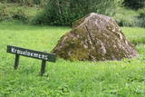
The restricted area was established to protect this part of the Ogre River valley, which has ancient river beds and meadows with relevant biotopes and populations. Among these are the wych elm and the European white elm, which are not often found in Latvia.
|
|
 |
Aizaudzis un purvains ezers - Ļūbasts, ar grūti pieejamiem vai nepieejamiem krastiem. Dabas vērošanai šobrīd nepiemērota vieta. Galvenās aizsargājamās vērtības - dažādas putnu sugas, t.sk. dzērves un melnie zīriņi.
|
|
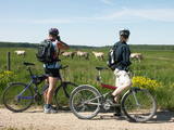 |
These meadows are of distinction because of the curvy Slampe River, which has caused a gradual recovery of damp meadows, complete with species of plants and animals that are typical of such areas. Domestic animals adapted for life in the wild can be seen here, and a bird watching tower on the location will offer you an excellent opportunity to view them. You can get to the meadows via a narrow corridor known as the Melnragu throat. The gravel road will lead to a hillock called Kurgāns from which you can have an excellent view of the surrounding landscape. |
|
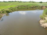 |
The Dviete Wetlands Nature Park contains a unique natural territory – the ancient Dviete River valley with the Lake Skuķi and the Lake Dviete and the surrounding wetland meadows. During flooding season, these wetlands store up waters from the Daugava River. They absorb a lot of floodwater at first and then slowly return it, thus reducing the level of floods in the Daugava River valley. This process is the reason for the unique ecosystem which exists in this area. It is an important location for plants and birds both during migration and nesting season. The river valley is important for birds during migration and nesting. In 2006, wild cows were released into the meadows. There is also work to improve the tourist infrastructure in the area. |
|
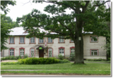 |
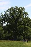
Oхраняемый вековой дуб местного
значения на краю улицы Тукума напротив Юрмальского
учреждения дошкольного развития "Пиенените".
|
|
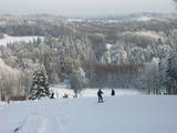 |
Gaiziņkalns Hill is the highest hill in Latvia, and it is a typical example of the hillocks of the Vidzeme highlands. This is a place of wonderful landscapes, even though there are not all that many good viewing areas. At the centre of this park is Gaiziņkalns Hill itself – the highest place in Latvia and the second highest in the Baltic States (311.6 metres above sea level). The viewing tower, alas is not open to the public, because it is in dangerous condition. There is a well-appointed hiking trail around Gaiziņkalns Hill, and during the winter the hill and its surroundings are popular for downhill and cross-country skiing. Lake Viešūrs (Lake Kaķītis) is popular among licensed fishermen. This territory is part of a region of protected landscapes around Vestiena. |
|
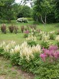 |
The park was founded by the gardener Arvīds Janitens. Professor Raimonds Cinovskis has said that Arvīds is just amazing, because he alone did work that would usually be done by a big group of people. This is one of the most popular tourism destinations of its kind in Latvia.
|
|
 |
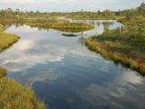
This is one of the largest areas of swampland in Latvia, lying between Lake Babīte and Olaine. Most of the area is still made up of peat. Relatively untouched is the northern part of the swamp, where there is a lovely set of swamp lakes, featuring landscapes of moss swamps. The heath is one of the few swamps in Latvia where the western-type and eastern-type swamp coexist. This is an important location for protected birds. A nature trail and viewing tower are to be installed at the heath in the near future.
|
|
 |
The tree is on the side of a hillock, and its visible roots are unusually huge.
|
|
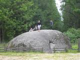 |
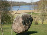
This territory was established to protect various kinds of rare butterflies A popular tourist destination in the Nīcgaļi forests is the great rock of Nīcgale, which is the largest rock in Latvia – a geological and geo-morphological monument of nature. The rock has a circumference of 31.1 metres, and it is 3.5 metres high, 10.5 metres long and 10.4 metres wide for a total size of 170 m3. |
|
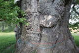 |
Сохранилась лишь небольшая часть мощных ветвей, самые толстые из которых поддерживаются подставками, а пустую середину от дождя и снега защищает козырек. Самый толстый черешчатый дуб (Quercus robur) в Латвии и во всей Балтии, и самое толстое дерево Балтии. Один из самых толстых дубов Северной Европы. Живописен. Невдалеке от дуба находится стоянка для автомобилей и информационный стенд. |
|
 |
This territory covers the shoreline between the Ventspils-Liepāja highway and the Baltic Sea on both sides of the Užava River. The territory was established to protect shoreline biotopes such as the grey dunes, as well as a number of endangered plants. To the South of the mouth of the Užava River we find one of the most romantic lighthouses in Latvia – the Užava lighthouse, which is at the top of a steep dune. |
|
 |
Rīgas – Daugavpils šosejas (A 6) malā (vietā, kur no Zemkopības institūta nogriežas ceļš uz Skrīveriem) redzama zema ieplaka ar Kraukļu akmeni, kas ir sena kulta vieta. Pie akmens veikti arheoloģiskie izrakumi, kuru laikā atrastas senlietas. Vecākā ir no 12. gadsimta. Akmens aprakstīts slavenajā Andreja Upīša (1877. – 1970.) darbā „Sūnu ciema zēni”. |
|
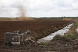 |
Nature restricted area is established to protect various wetland habitats – Big Kirba Bog and protected plant species within it. Only the West part of the Bog is a protected nature area. The rest of the bog is used mainly for intensive extraction of peat and large cranberry cultivation. Nature restricted area of the bog has no tourism infrastructure therefore is not useable for tourist visits.
|
|


