
| Нo | Название | Описание |
|---|---|---|
|
|
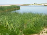
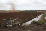
No ūdens tūrisma attīstības centra „Bāka” skatu laukuma, kas atrodas Lubāna ezera ziemeļdaļā pie V 560 autoceļa, paveras viens no labākajiem Lubānas ezera skatiem. Redzams milzīgais Latvijas lielākā ezera klajs un Kvāpānu – Īdeņas zivju dīķu ar dambjiem ainava. |
|
 |
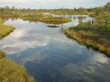
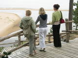
This area is full of coastline meadows, lagoons, muddy little lakes and sandy shallows, all full of reeds. This area of the eastern shore of the Bay of Rīga is found between Ainaži and Kuiviži. The Randa meadows are an enormously important location for water birds and rare plants – some 500 in all. A new bird-watching tower and a nature trail have been established for those who wish to study the meadows.
|
|
 |
The Ķemeri National Park was established in 1997 and mostly involves wetlands – the shallow shores of the Bay of Rīga, an overgrown seaside lake, vast swamps, damp forests and fens, and flood-land meadows. The park is enormously important for protecting plants (25% of those recorded in Latvia’s Red Book are found in the park) and animals, particularly nesting and migrating birds. The Great Ķemeri Bog is one of the largest swamps in Latvia, and there are other swamps, as well – the Zaļais swamp and the Raganu swamp. The massive swamps are important, too, in the flow of sulphuric waters and medicinal mud. The once-famous Ķemeri Spa was based on the availability of these resources. Most of the cultural and historical objects in the Ķemeri National Park relate to the seashore as a place for leisure and recuperation. Educational nature trails, bicycle trails, hiking trails, bird-watching towers and other facilities are available. The visitors centre is at the recently renovated “Forest House” in Ķemeri. |
|
 |
Atrodas ~ 1,5 km ziemeļos no Krāslavas centra, Jāņupītes krastā (ir norāde). Pēc atsevišķiem savrupatradumiem var spriest, ka pilskalns apdzīvots laikā no I g. t. pr. Kristus līdz vēlajam dzelzs laikmetam. Domājams, ka savu nosaukumu tas ieguvis šeit sastopamo mālu dēļ. Nelielas mālu ieguves vietas pilskalna nogāzēs ir redzamas arī šodien. Saglabājies nostāsts, ka grāfs Plāters šeit apraudājis savu sievu, kuru pats neuzticības dēļ licis iemūrēt pazemē. |
|
 |
Neskartu mežu cienītāji var doties izpētīt Plakanciema puses mežu takas. Braucot no Plakanciema pasta nodaļas Mellupu virzienā pa autoceļu V7, pēc aptuveni 1 km jānogriežas ceļā pa labi. Tālāk jādodas uz priekšu vēl 1,2 km. Maršruta sākums - iepretī mājām “Putriņas” ceļa kreisajā pusē, kur sākas meža ceļš. Sākumā maršruts ved pa taisnu meža ceļu. Pēc 500 m nonākam pie ūdenskrātuves (karjera). Šeit ir iespēja doties vai nu gar vienu ūdenskrātuves krastu, vai gar otru. Abās pusēs var aiziet aptuveni līdz ūdenskrātuves pusei un tad griezties atpakaļ. Krastā augošos kokus iecienījuši bebri. Ūdenī peldas pīles, meža ceļa malā vairāki skudrupūžņi, no sakritušo pērno lapu apakšas lien ārā zaķskābenes. |
|
 |
Augstā un purva vidusdaļā - pārejas tipa purvs, putniem nozīmīga vieta. Apmekļējumiem nav piemērota infrastruktūras trūkuma un sugu aizsardzības nolūkā. |
|
 |
There is no need to enter the bog to see it, there are good views from the highway Ventspils – Riga (77 km, bus stop “Pagrieziens uz Elkskeni”). The main value of restricted area is chalky fen bog with brown bog-rush (greatest habitat finding in Latvia). Be careful when stopping on the highway – mind the traffic! A couple of kilometers towards Riga, on the right side of the highway, there is sign to Grizu Velna kresls ( Grizu Devil Chair) which is an attractive boulder (protected).
|
|
 |
Яунсташульский камень чертова следа находится в деревне
Яунсташулю, в зарослях около заброшенных домов. Без знающего
человека это место трудно найти. Высота камня от земли 0,75 м,
окружность около земли 5,85 м. На его поверхности отпечатался человеческий след, длина которого
0,3 м, ширина 0,09 м, глубина 0,02. Был еще второй след, но, очевидно, откололся. В северный бок
камня как бы ударили три ступни.
|
|
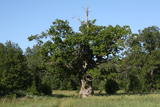 |
The tree is in the middle of an untended field. Despite many dead branches and the messy surroundings, the tree is beautiful and well visible from the road. It is the third thickest tree in the Baltic States.
|
|
 |
Nature restricted area is established to protect various wetland habitats – Big Kirba Bog and protected plant species within it. Only the West part of the Bog is a protected nature area. The rest of the bog is used mainly for intensive extraction of peat and large cranberry cultivation. Nature restricted area of the bog has no tourism infrastructure therefore is not useable for tourist visits.
|
|
 |
Валгумс или седумс – так называлась песчаная прибрежная полоса между дюнами и водой, где стояли лодки и сушились сети. Каждому селению принадлежало несколько пляжей, которые в 20-30 г.г. 20 века имели большое значение для сохранения языка ливов. |
|
 |
Широкий камень. В волости Маконькалнс, недалеко от камня
Ажмугурас, на краю небольшого болота спит Широкий камень. В
отличие от своего соседа – плоский. Вокруг обоих камней завито
много рассказов. Один гласит, что камень Ажмугурас – часть
Широкого камня, а также, что накопившаяся дождевая вода во впадине Широкого камня может лечить
бородавки.
|
|
 |
Горы Крачу (Крацкални) – цепь волнистых
холмов, сформировавшихся во времена
Литоринского моря под действием сильных
ветров. Прекрасный вид на Озеро лилий.
Напротив озера, с восточной стороны упомянутой
дороги по доломитной лестнице попадаем к
памятнику, установленному в честь 90 латышских
стрелков, которые пали в сражении 1917 г.
|
|
 |
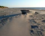
The Sunset trail starts in the centre of Saulkrasti town and takes you to the White Dune. Saulkrasti town with its municipal rural territory, occupies a 17km long stretch of coastal land to the North from the river Lilaste and the lake Lilaste. The White Dune stands on the right side of river Inčupe mouth. It is covered by old pine forest. The white, 18m high sand outcrop in olden times served as a landmark for fishermen. The White Dune formed as winds carried the sand from the beach over clay sediments of the Baltic Ice Lake. Some 150-200 years ago, the dune had been drifting as witnessed by several layers of soil buried within it. Local fishermen and farmers at Bātciems initiated afforestation of the drifting dunes. At that time, the 30m high dunes which are now covered with forest, were bare, shifting and even buried a farmstead. To speed up afforestation, mountain pines were planted. The White Dune was partly washed away in heavy storm in 1969, and 4-6m high precipice formed. Now the wind and sand have levelled out the dune surface, it has been fixed with willow-twigs or grown with forest where the largest pines are more than 170-190 years old. The pines are notable with their large trunks and branches, the scars obtained during their lifetime and the typical “crocodile skin” – the bark forms rhombuses resembling those of the reptile’s scales. Scots Pine (Pinus Silvestris) is one of the most common tree species in Latvia. It grows in dry, meagre sandy soil in dunes as well as in marsh. However, it does not stand overshadowing. Forest fires help pines to get rid of competitors as pine endures fire better than other trees because of its thick bark and high crown. The wood exudes resin and burned wounds close soon. Fire cleans space for seedlings of young pines. Pines can live 300-350 years. Ground cover in dune forests is very sensitive. If the sparse vegetation is destroyed, not only the natural biodiversity and landscape is damaged, but also the dangerous shifting dunes can possibly “wake up”. Embryonic dunes, White (yellow) dunes, Grey dunes and Wooded dunes are EU protected biotopes. Grey Dunes are protected by Latvian law as well. |
|
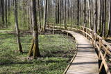 |
The excessively damp forests at this place include the Vēršupīte River bog, and this is one of the most diverse biotopes in Latvia in terms of the number of species that can be found here. The fact that the area is regularly flooded is shown by the fat roots of black alders – indeed, the place looks like a stand of mangroves. The wooden pathway that is the Dumbrāju trail starts at the Forest House for those who wish to examine the bog. The most impressive views are seen during spring floods or rainy seasons at other times of the year. The little river breaks out of its bed and floods a large territory. The Lake Sloka hiking trail is another place where you can study the Vēršupīte bog. The circular trail is 3 km long, and its beginning is at the Lake Sloka bird watching tower. |
|
 |
Vairāki dažus metrus augsti smilšakmens atsegumi, kas izveidojušies Stiglavas (Stiglovas) strauta gravas nogāzēs. Kaut arī teritorija tiek popularizēta kā tūrisma objekts, tajā nav īpašu šim nolūkam paredzētu labiekārtojumu. Teritorijas apmeklētāji bojā smilšakmens atsegumus, kas ir aizsargājami biotopi!
|
|
 |
The most important aspects of this park are a shallow lagoon-type lake – Lake Pape, with its flood land meadows, the shore of the Baltic Sea, the Nida swamp, and the more than 270 different types of birds that have been spotted here. The oldest bird ringing station in Latvia (est. 1966) is found between Lake Pape and the Baltic Sea. Birds and bats are caught and ringed there. Lake Pape is the first place in Latvia where so-called “wild” horses (the “Konik” breed) were released with the aim of managing the flood land meadows.
|
|
 |
Казиньмежс – небольшой лесной массив на востоке от перекрестка дорог
Цирсте – Мазирбе и Колка – Вентспилс. Место преданий. Через Казиньмежс по доро-
ге Крустцельш доходим до перекрестка дороги Колка – Вентспилс (Р 124).
|
|
 |
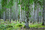
Bejas meža dabas liegums veidots no reljefa viedokļa - interesantā, pauguru un starppauguru ieplaku saposmotā teritorijā, kuru klāj vecs un varens egļu mežs. Bejas mežā atrodas viena no Alūksnes rajonā vairākām "Velna pēdēm" - dziļa, krāterveida ieplaka, ko veidojis kūstošais ledājs.
|
|
 |
Ķurmrags is one of the most distinct capes along the Vidzeme shore of the
|
|


