
| Нo | Название | Описание |
|---|---|---|
 |
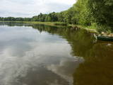
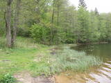
The Slocene River flows through Lake Valgums and Lake Mazezers before flowing into the western part of Lake Kaņieris. It is part of a branched and swampy delta in which there are seasonal restrictions aimed at protecting birds. The wetlands which are alongside the river are difficult to access in many places. Before the Starpiņupīte was dug between Lake Kaņieris and the Bay of Rīga (the water level is regulated with sluices), the water from the river flowed along what is now the Vecslocene River all the way to Sloka, where it ended at the Lielupe River. The Vecslocene can be used by canoe boats only when the water level is high and then from the Old Ķemeri road to the place where the river enters the Lielupe. Between Milzkalne and Lake Valgums, the river is not navigable because of many fallen trees. During the springtime, the estuary of the Starpiņupīte is a good place for bird watching. |
|
 |
The trail tells about the protected nature area which is found in Riga city and has been established to protect the seashore habitats (forests, meadows, reeds, dunes) and the birds, populating the daugavgrīva meadows. There is a bird watching tower with facilities for people with special needs.
|
|
 |
Западное побережье Рижского залива – важное место пристанища и питания большого количества мигрирующих пород птиц на протяжении года. Наиболее встречаемые виды птиц - краснозобая и чернозобая гагара, юрмальская большая утка, морянка, темная утка и малая чайка. Территория находится напротив Дундагского, Ройского и Энгурского края, а также города Юрмалы, площадь – 132 173 га. Территория включает морскую часть природного парка «Энгуре» и Кемерского национального парка.
|
|
 |
This nature park was established to protect the Burzava hillocks, Lake Adamova (a eutrophic lake), and the habitats and species that are found along the lake’s shores – bats included. The loveliest views of the area can be viewed from the hillocks that are on the northern shore of the lake. There are tourist accommodations on the shores of Lake Adamova where tourists can spend the night. |
|
 |
Ar mežiem, purviem un ezeriem (Riču, Sila u.c.) bagāta teritorija Latvijas - Baltkrievijas pierobežā. Galvenās aizsargājamās dabas vērtības - dažāda veida purvu, mežu un ezeru biotopi un tajos mītošās augu un dzīvnieku sugas. Ezeru krastos, kurus iecienījuši vietējie atpūtnieki, atrodas vairākas naktsmītnes. Ilgas muiža (celta 19. gs. kā medību pils) ir Daugavpils Universitātes studentu prakses vieta. Silenes dabas parkā ietilpst arī Glušonkas purva un Ilgas dabas liegumi.
|
|
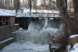 |
Atrodas pie Kuldīgas pils dzirnavām, kur straujā Alekšupīte pirms ietekas Ventā izgrauzusi dziļu „kanjonu” dolomītā. Šo dēvē par vienu no augstākajiem Latvijas ūdenskritumiem (4,15 m). 17. gs. ūdenskritumu ievērojami pārveidoja – paaugstināja un nostiprināja, lai Alekšupītes straumi izmantotu dzirnavu darbināšanai. Upītes kreisais krasts ir labiekārtots. |
|
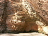 |
For more than a century now, the Gūtmaņa cave has been a popular tourist destination. It is the widest (12 m) and highest (up to 10 m) cave in Latvia. It is more of niche, actually, because its depth is just 18.8 metres. The cave is an interesting geological monument, as well as an important cultural and historical place with lots of legends, among which the most popular one centres on a woman called the rose of Turaida. It seems, however, that of the greatest historical values are the engravings on the walls and ceilings of the cave. The oldest date back to the late 17th century. A stream flows out of the cave, and it continues to shape it. People believe that the water from the stream has medicinal properties. Nearby there is Tourist Information Centre Gutmanala. Office hours: 01.05.-30.09. from 9.00 – 19.00; 01.10.-30.04. from 9.00 – 18.00. Prices for parking: 1 car EUR 2,50; 1 minibus EUR 5,00; 1 bus EUR 7,00. |
|
 |
Думельские озерные луга – место, окутанное преданиями и историями о
том, что здесь когда-то было озеро Видала (Божка), воды которого в 1838 г. ушли в
море. Интересно,
что на дне озера, после ухода вод, нашли древние сваи и остат-
ки кораблей.
|
|
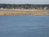 |
The restricted area protects the seashore meadows of the Lielupe River estuary, which are a very uncommon habitat in Latvia. The restricted area is on the left bank of the river, where one of the largest areas of wild swamp angelica is found. This is an important nesting area for birds. The territory is not improved for tourism, and it should be viewed from the Baltā (White) dune that is on the opposite bank of the Lielupe River. From there, the visitor will see a lovely landscape featuring the river estuary and the meadows which are around it.
|
|
 |
Гора Мицану-Киркас. Маленький замок в Приежукалне в
1792 году был преобразован в лютеранскую церковь. До сих пор
гору называют „Кирха” (нем. Kirche – церковь). Пожилые люди
говорят, что под церковью был построен большой подвал, в котором хранились драгоценности семьи
Мантейфелей и церкви, в подвале находится семейный склеп Мантейфелей.
|
|
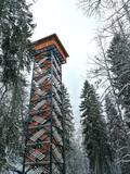 |
Dabas liegumā "Lielie Kangari" atrodas 33 metrus augsts skatu tornis, kura virsotnē atrodas platforma, no kuras paveras skats uz Kangaru ezeru un Lielkangaru purvu. Dabas liegumā izbūvēta arī nepilnu divu kilometru gara pastaigu taka ar tiltiņiem un skatu platformu pie ezera. Takas sākumā izvietotais veselības maršruts ikvienu apmeklētāju aicina kārtīgi izvingroties un izkustēties. Apmeklētāju informēšanai un izglītošanai visas takas garumā izvietoti arī informatīvie stendi ar fotogrāfijām, kas apvieno varenu stāstu un teiku kopumu par notikumiem, vietām, tēliem un parādībām dažādās apkārtnes vietās. |
|
 |
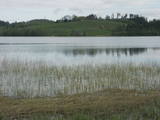
Dabas parks, kura lielāko daļu aizņem neprastās formas un līčiem bagātais Cārmaņa (arī Cārmins) ezers. Ezera ūdens ir ļoti tīrs, tādēļ tajā sastopamas Latvijai retas augu sabiedrības. Tā kā parka teritorijā nav tūristiem veidota infrastruktūra, interesenti var baudīt skatus, kas paveras uz ezera un tā apkārtni no Aulejas – Grāveru ceļa.
|
|
 |
Находится около Улмалес, примерно в 300 м от шоссе Лиепая - Вентспилс (есть указатели). Очень красивый и ярко выраженный камень с углублением, в верхней части которого продолблено углубление глубиной 15 см и диаметром до 61 см. Предположительно, что здесь (особенно в 16 - 18 вв.) было старинное культовое место. |
|
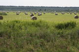 |
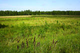
Open landscape area within farming lands on both banks of Uzava River about 10 km before it flows into the Baltic Sea. There is a good open view over the area from the Vendzava-Ziri road going through the nature park. Protection of migratory birds and corncrakes has been one of the main reasons for establishment of the nature park. Bird watching is possible from the road Vendzava-Ziri during migration period in spring and fall. There is no tourist infrastructure in the nature park.
|
|
 |
В северной части Рубени, на берегах Дзирнавупите разбит парк (формирование начато в 50 годах 20 столетия) с живописными прудами, эстрадой, садом камней и детскими игровыми площадкам. Дом культуры, находящийся рядом с парком, построен в 1969 году. Во время Дней поэзии открыт памятник Райнису (автор - скульптор Карлис Бауманис).
|
|
 |
Доле является самым большим островом на Даугаве. С северо-востока его омывают быстрые воды Даугавы, а с юго-запада – спокойные и понемногу зарастающие воды бокового русла Даугавы. Острову присвоен статус природного парка (Особо охраняемая природная территория). Парк основан в 1987-м году с целью сохранения оставшегося после постройки Рижской ГЭС ландшафта острова и культурно-исторических ценностей, а также редких и охраняемых видов растений и животных. Еще одна цель образования парка – способствование просвещению и отдыху общества. Одним из известнейших объектов осмотра острова Доле является музей Даугавы, размещенный в жилом здании поместья Доле. В коллекции музея находятся ~ 13 000 различных экспонатов – свидетелей истории острова Доле и берегов Даугавы – одежда балтов и ливов, орудия труда, предметы быта. Экспозиция знакомит с историей Даугавы как значимого водного пути, а также с историей плотовщиков и транспортных средств этого пути. В парке поместья Доле размещена музейная экспозиция под открытым небом с реконструкцией заколов для миног и запруды для ловли лосося и коллекцией рыболовных снастей. Возле музея на обрывистом берегу бокового русла Даугавы находится доломитовое обнажение. На юго-востоке острова на берегу Даугавы возле хутора Бечи можно осмотреть руины замка Вецдоле. |
|
 |
The most important aspect of the Sasaļi forest is the eutrophic Lake Sasalis, as well as the unusual Lake Melnezers. Also of importance are various types of forestland in the area. Lake Sasalis is a popular place for leisure and swimming.
|
|
 |
Большой чумной камень – с вырубленными письменами (немного еще про-
сматриваются), обращенными к будущим поколениям и повествующими о местном
пасторе того времени, который умер от чумы, и о создании пастората в Сикраге,
который в последствии был перенесен в Мазирбе. Чумной камень является и памят-
ником шести пасторам обширной окрестной общины. Все три камня повествуют о
Великой чуме 1710 года, а письмена на камнях вырублены во времена мазирбского
пастора Петерсона с 1711 по 1734 год.
|
|
 |
Охраняемая морская территория Нида – Перконе является одной из биологически многообразных и важных с точки зрения охраны природы морских территорий на побережье открытой части Балтийского моря – здесь находятся выдающиеся территории рифов. В период миграции территорию пересекает большинство мигрирующих пород птиц, встречающихся в Латвии. Расположенная напротив Руцавского и Ницского края территория площадью 36 703 га особенно важна для защиты большого крохаля и малой чайки. Территория частично перекрывается морской частью природного парка «Папе» и включает морскую часть территории природного парка «Бернаты».
|
|
 |
Atrodas ~ 0,4 km no Latvijas – Lietuvas robežas, Sventājas ielejas labā krasta nogāzē. Atrodama informācija, ka avotu tīrot, atklājusies 5 x 5 m ozolkoka „grīda”. Avots ir labiekārtots – virs tā slejas lapene ar niedru jumtu. Vēl pavisam nesen pie tā auga Latvijas dižākā ieva (nolūza), kuras vietā tagad kuplo biezs atvašu pulks. |
|


