
| No | Name | Description |
|---|---|---|
 |
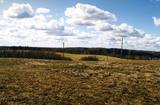
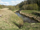
This is a small area with lots of different terrains – high hillocks, distinct river valleys, thermal streams, continental dunes, etc.
|
|
 |
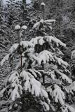
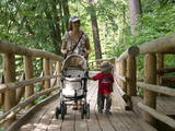
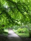
The nature park in the city of Jūrmala was set up to protect dune, pine forest and shoreline habitats. This park features one of the most attractive nature trails in the Rīga area, and it is found near the famous Ragakāpa dune, which can be as much as 17 metres high. This is an excellent opportunity to study dune habitats and the plants, birds, insects, etc., which live there. Visitors can also see pine trees that are 100 years old and older. |
|
 |
Teritorijas apskates nolūkos ir izveidota un labiekārtota dabas izziņas taka. Dabas liegums atrodas Abavas senlejas dabas parka teritorijā. Taka iepazīstina ar vienīgo krūmu čužas savvaļas augšanas vietu Latvijā. |
|
 |
Atrodas Skuķu ezera dienvidrietumu krastā. Sasniedzams no Putnu salas, ejot cauri dzīvei savvaļā pielāgoto mājlopu aplokiem un taku. No torņa labi pārskatāma Dvietes paliene (ūdeņainos pavasaros pārplūst) un aizaugušais Skuķu ezers. Laba putnu vērošanas vieta. Putnu salas Atālu mājās – vietējais gids. |
|
 |
No ģeogrāfiskā un kultūrvēsturiskā viedokļa interesanta teritorija Latgales augstienes Rāznavas paugurainē, kuras nozīmīgākie resursi ir dažāda veida biotopi, ainavas, reljefs un Šķaunes ezers. Istras pauguraines dabas parkā nav ar tūrismu saistīti labiekārtojumi, bet šo teritoriju var apskatīt arī „no malas”, braucot pa grantēto ceļu no Soboļinas uz Osinovku, kas iet līdztekus parka ziemeļu robežai (skats uz Šķaunes ezeru).
|
|
 |
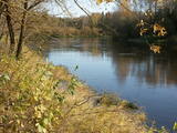
The nature park in the Ogre River valley is found along the middle section of the river. It has been established so as to protect the unregulated river valley and its surrounding territory, as well as biological diversity and habitats. For instance, this is an area in which rare park-type meadows can be found in Latvia. The Ogre is one of Latvia’s most popular rivers for water tourism in the spring, particularly downriver from the town of Ērgļi, where the technically complicated Braži rapids are found. |
|
 |
Teritorija, kas aptuveni 20 km garumā „piekļāvusies” abiem Aiviekstes upes krastiem. Dabas parka galvenā vērtība ir palieņu pļavas (un citi pļavu biotopi), kas ir ļoti nozīmīga daudzu augu un dzīvnieku (īpaši – putnu) sugu dzīves vieta. Ūdenstūristiem, kas laivo pa Aivieksti, nakšņošana ir jāplāno tikai šim mērķim paredzētās vietās!
|
|
 |
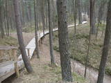
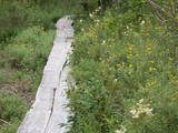
One of the most attractive and informative nature trails in the environs of Rīga. It leads the visitor around the 17-metre Ragakāpa dune, which is most interesting. People can learn about the habitats of the dune areas and the plants and animals of the area. Some of the pine trees are as much as 100 years old and more. The trail is 2km long in each direction and will take some two hours to traverse. This is part of the Ragakāpa nature park.
|
|
 |
This park is located along the shores of the Tērvete River Valley. It is a vast forested area which has been adapted successfully for travellers. In 2004, it was nominated as the most family - friendly destination in the land. There is a web of trails for one-day hikes. Viewing tower on the shore of the Tērvete River, views also from the Tērvete castle hill and Zviedru (Swedish) Hill.
|
|
 |
The nature park in the Daugava River valley is the only place between the cascades of the Daugava hydroelectric power plants there is still a chance to see the Daugava River valley and the ravines of its tributaries as they appeared before the area was flooded so that the power plants could be constructed. Particularly lovely views are found on the right bank of the river near the Aizkraukle church and castle hill. Forests, meadows, origins of streams and small dolomite cliffs in this area are all protected biotopes. Leisure facilities have been installed on the Aizkraukle castle hill, and the Aizkraukle castle ruins are not far away. |
|
 |
Kuģinieku drošībai 1875. g. celtā bāka stipri cieta 1. pasaules kara laikā. Savu tagadējo izskatu tā ieguva pēc atjaunošanas 1922. g. Bākas uguns atrodas 21,3 m v.j.l. un tās detaļas savulaik vestas no Francijas. Pie bākas ieejas 1975. g. uzstādīta piemiņas plāksne par godu bākas simtgadei. Pie bākas atrodas bijušās padomju armijas militārās bāzes atliekas. |
|
 |
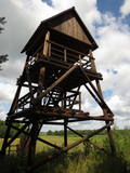
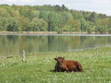
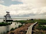
The tower on the eastern shore of Lake Engure (next to the meadow for wild cattle, accessible from the side of Bērzciems) offers a view of the reeds, small islands, Great Island, cows and horses of the north-eastern part of the lake. The tower on the northern shore of the lake (accessible from the side of Mērsrags) offers a look at the boating facility and the very overgrown northern part of the lake. The tower at the north-western shore of the lake (accessible from the side of Ķūļciems) shows the Apaļrova island (a footpath), stands of juniper, the boating facility, and the mosaic-like landscape of the lake itself.
|
|
 |
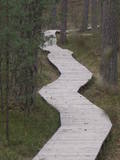
Engures apkaimē aug 22 no Latvijā sastopamajām 32 orhideju dzimtas sugām .Lai dabas parka apmeklētājiem dotu iespēju aplūkot šīs interesantās augu sugas, ierīkota Orhideju taka. Kopējais takas garums ir 3.5 km, tā sākas netālu no Engures Ornitoloģisko pētījumu centra, līkumo caur kalcifilajiem purviem un mežam putnu novērošanas torņa virzienā, un aizvijas tālāk gar atjaunoto ezera piekrastes pļavu, kurā mīt govis un zirgi. Takas sākumā novietotajā informācijas zīmē attēlotas ne tikai apkārtnē sastopamās orhidejas. Tur iespējams gūt daudzpusīgu informāciju arī par citām interesantām Engures ezera dabas parka augu sugām.
|
|
 |
Riežupes dabas parks veidots g.k. Riežupes izteksmīgās ielejas, tai raksturīgo dabas vērtību – nogāžu un gravu mežu, dažādu ģeoloģisku dabas pieminekļu - smilšakmens atsegumu, alu, ūdenkritumu, upes straujteču posmu, dažādu sugu, mežu masīvu un ainavas aizsardzībai. Parka atrodas viens no Kurzemes populārākajiem tūrisma objektiem – Riežupes alas - garākais mākslīgo alu labirints Latvijā, kura eju kopgarums ir 460 m. Sākotnēji dabas veidotās alas 19. gs. vidū mākslīgi paplašināja baltās smilts ieguves nolūkos, kuras izmantoja stikla ražošanai. Parkā izveidots velotūrisma maršruts. |
|
 |
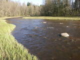
Open landscape area within farming lands on both banks of Uzava River about 10 km before it flows into the Baltic Sea. There is a good open view over the area from the Vendzava-Ziri road going through the nature park. Protection of migratory birds and corncrakes has been one of the main reasons for establishment of the nature park. Bird watching is possible from the road Vendzava-Ziri during migration period in spring and fall. There is no tourist infrastructure in the nature park.
|
|
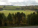 |
As you travel from Kandava to Sabile, you will find a parking lot on the right side of the road. From there, there are steps to a viewing area on the highest hill in the Abava Ancient River Valley – Greiļi Hill. This offers a wonderful view of the ancient river valley and the local mosaic of meadows and forests. The landscape is enriched by the Imula and Amula valleys that are on the other side of the ancient river valley.
|
|
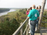 |
The old wooden tower at this site was torn down and replaced with the one that is there now. The restored tower offers one of the loveliest views in Eastern Latvia – one of the eight curves of the Daugava. This is the Rozališki curve. Here you will get a whole new sense of the Daugava River and its mighty valley in a place where the waters of a hydroelectric plant bubble away in our present day and age. It is claimed that the scene that is seen on the 10 lats note is based on the view which can be seen to the West from the tower. |
|
 |
Tītuvēnu reģionālais parks (Tytuvėnų regioninis parkas) dibināts 1992. gadā. Parkam raksturīga ainavu daudzveidība – te ir sastopami lieli mežu masīvi, purvi, ezeri, upītes. Šejienes reljefa veidotājs tāpat kā citur Baltijas valstīs ir bijis ledājs, kas atnesis un atstājis aiz sevis garas laukakmeņu grēdas. Kopumā parkā ir konstatētas 603 augu un 787 dzīvnieku sugas. Parkā aug veci un dabiski boreālie (ziemeļu) meži, veci un jaukti platlapju meži ar ozoliem, liepām, kļavām, ošiem un gobām, sugām bagāti egļu meži, staignāju meži, nogāžu un gravu meži, purvaini meži un aluviālie (pārplūstošie) meži. Parkā esošās pļavas un tīrumi ir nozīmīga dzērvju atpūtas vieta migrāciju laikā, kad te pulcējās tūkstošiem putnu. Šiluvas baznīca un Tītuvēnu klosteris ir svētceļnieku galamērķis vairāk nekā 500 gadu garumā. |
|
 |
Established: 1931. The arboretum was set up at the suggestion of Latvia’s distinguished author Anna Brigadere. After her death and until 1935, the arboretum was supported and expanded by book publisher Jānis Rapa. There are some 180 foreign trees and shrubs of various kinds here. Some of the plants are outside the arboretum itself.
Unique plants: The Bunge’s Ash (Fraxinus chinensis), the Eastern Black Walnut (Juglans nigra), the American Buckeye (Aesculus glabra), the Smoketree (Cotinus coggyria), the White Mulberry (Morus Alba), and the Kentucky Yellowwood (Cladrastis kentukea).
|
|
|
|
Veisieji reģionālais parks (Veisiejų regioninis parkas) veidots (1992.g.) Sudavas augstienes (Sūduvos aukštuma) ainavu, bioloģiskās daudzveidības un kultūras pieminekļu aizsardzībai. Viena no parka bagātībām ir ezeri, kuru iegarenās formas liecina par ledāja darbības rezultātu. Pēdējā apledojuma laikā šeit atradusies ledāja mala. Ezerus (kopā – 37) ieskauj lielāki meža masīvi uz kontinentālām (iekšzemes) kāpām, kas piemēroti atpūtai dabā, dabas vērošanai, ogošanai un sēņošanai. Parkā ir iekārtotas peldvietas, kur patīkami gremdēties vasaras tveicē, izveidotas dabas takas, bet mazās upītes, kas savieno ezerus, ir piemērotas braucieniem ar kanoe laivām. Veisieji reģionālā parka teritorijā ir liela augu un dzīvnieku daudzveidība. Šeit tiek aizsargātas arī tādas retas sugas kā Eiropas kokuvarde Hyla arborea (parka simbols), purva bruņurupucis Emys orbicularis, dažādas orhideju sugas u.c. |
|


