
| No | Name | Description |
|---|---|---|
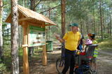 |
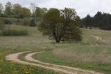
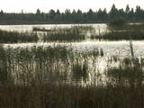
The wooden pathway which crosses the high swamp leads to the Teirumnīku swamp lake, which is right in the middle of the swamp. On the shores, there is a well-appointed place for leisure and relaxation. One can return to the starting point via a forest path. The trail is 800m long, and visitors will spend about an hour there. It is a part of the Tīrumnieki nature reserve.
|
|
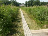 |
The best place to look at the restricted area of the Vīķi swamp and the Lielauce lake which is in the middle of that swamp is the Lielauce castle, where a wooden pathway stars. The pathway will lead visitors across the swampy shores of Lake Lielauce and deliver them at a boating area on the open part of the lake. The swamp itself is to the South-east of the lake. The restricted area is there to protect biotopes and species in the area. |
|
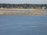 |
The restricted area protects the seashore meadows of the Lielupe River estuary, which are a very uncommon habitat in Latvia. The restricted area is on the left bank of the river, where one of the largest areas of wild swamp angelica is found. This is an important nesting area for birds. The territory is not improved for tourism, and it should be viewed from the Baltā (White) dune that is on the opposite bank of the Lielupe River. From there, the visitor will see a lovely landscape featuring the river estuary and the meadows which are around it.
|
|
 |
Most of this restricted area is made up of a shallow and eutrophic body of water in which many species of birds, including some that are rare and protected, nest. Specialists say that anywhere between 150 and 450 pairs of black-headed gulls nest in this area on a regular basis.
|
|
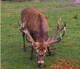 |
he wetland meadows that are around the Pededze River are the site of this 200 ha farm with some 350 red deer, other deer and wild boar. There are towers from which you can watch the graceful animals, and there are ponds for commercial fishing. Please contact the owner well in advance for a tour. |
|
 |
This is the only viewing platform of its kind. It is north of Pāvilosta, between the sea and Latvia’s largest gray dune. The second level of the platform offers a good view of the habitats which surround the dune, as well as the seashore and the largest seashore rock on the shores of the Baltic Sea – the Pāvilosta sea rock. You can also see the northern part of Pāvilosta. When it is windy outside, you’ll see kiteboard riders showing their tricks.
|
|
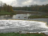 |
The recently renovated old brick bridge and the viewing area that is on the left bank of the Venta beyond the castle guard’s hut offers a lovely view of the widest and most impressive waterfall in Latvia – the Venta falls. It is worth visiting during the spring floods, when fish are migrating.
|
|
 |
A small and forested territory with sulphurous springs, among which the most popular one is the Ellīte sulphur spring. It has sulphurous water with a low level of minerals, and the water supposedly has medicinal properties. The area around the stream is well-appointed, and a pathway leads to it. The stream is considered to be the source of the Iecava River. The restricted area is there to protect biotopes and protected plants which are in the area.
|
|
 |
This is an uncommon landscape for the Kurzeme region with a protected biotope – open inland dunes with meadows of silver grass and forests of deciduous trees, including the common hornbeam. Tourists can visit the Muiža (Lejas) sacred stream on the right bank of the Sventāja valley, above which they will find Latvia’s most noble bird-cherry trees. A nice reed pergola has been installed above the stream. Wide are of Sventāja River valley can be overseen from the road before the stream. |
|
 |
This structure is smaller than the Great Kangari hills – approximately 10 kilometres long and 16 metres high. This structure is near the Buļļi swamp, and the restricted area is meant to protect the structure, the swamp and the various forest types and rare plants that are in the area.
|
|
 |
One of the rare places (see also Rucavas ivju audze) in Latvia where two rare and protected wild tree species grow - yew-tree and Baltic ivy. Territory is not marked on site with information signs or stands therefore it is hard for visitors to find. Not usable as tourism object.
|
|
 |
Similar as Alsungas mezi (Alsunga forests) – is not intended and appropriate for visits. A narrow path of the restricted area can be seen from the gravel road – Saka-Apriki. Nature restricted area established mainly for protection of Erica tetralix (often called "cross-leaved heath") and it is one of the most important growing places.
|
|
 |
Peat moss has been extracted from the Seda heath since the middle of the last century, but it is nevertheless one of the most important NATURA 2000 territories in Latvia, with a great diversity of landscapes, biotopes and biology – birds in particular. This is a good place for bird-watching during migration season, and viewing towers have been set up on the edge of the swamp for this purpose.
|
|
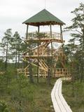 |
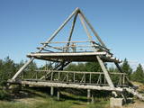
This is part of a hiking trail along the Cena bog. It is on the western side of the bog, at the centre of the 5-kilometre circular trail. You can see the vast swamp, as well as a military road that was installed during World War I and is marked by an “alley” of large pine trees. Alongside the tower is a fragment of the road that was installed more recently.
|
|
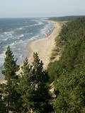 |
Construction on the lighthouse was initially completed in 1879. The structure suffered damage during both world wars and was restored several times. The structure is 19 metres high and stands 46.5 metres above the wavy sea. Here you will find one of the loveliest views of the shores of the Baltic Sea.
|
|
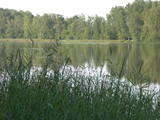 |
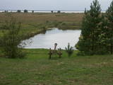
These two lakes, along with Lake Mazezers, Lake Auziņš, Lake Skuja and Lake Bruņķītis, are found in a sub-glacial depression with shores and hillsides that are home to various kinds of forest, including stands of broadband trees such as ash. These are protected habitats. Alongside the Priedītes homestead there is a well-appointed nature trail for visitors who wish to study Lake Dziļezers and its surroundings. A boating facility is on the north-eastern shore of the Lake.
|
|
 |
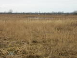
Nature restricted area is established to protect various wetland habitats – Big Kirba Bog and protected plant species within it. Only the West part of the Bog is a protected nature area. The rest of the bog is used mainly for intensive extraction of peat and large cranberry cultivation. Nature restricted area of the bog has no tourism infrastructure therefore is not useable for tourist visits.
|
|
 |
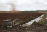
Along with the Nagļu ponds, these are Latvia’s largest fishing ponds. They were established on the flood-land peat areas of Lake Lubāns in the 1970s, when the hydrotechnical system of the lake was first established. The Lubāna-Gaigalava road bisects the Kvāpāni-Īdeņa ponds. There are three bird-watching towers on the dams of the ponds. The ponds are a major location for water bird nests, as well as places for migrating birds to rest. There are extensive bird-watching opportunities in the area.
|
|
 |
The restricted area was set up to protect Nesaule Hill, which is a forested hillock in the area and features boreal and damp forests.
|
|
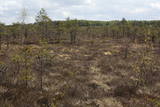 |
Territory established mainly for protection of bog myrtle and various bird species. An interesting fact is that bog myrtle or sweet gale is used as ingredient for making famous Riga Black Balsam. Brienamais purvs (wade bog) is hard to find and reach therefore it is not suitable for tourism.
|
|


