
| No | Name | Description |
|---|---|---|
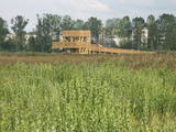 |
This is one of the most interesting protected territories in the city of Rīga, and its aim is to protect coastline biotopes – dune and coastal meadows and the birds and plants which are found there (among them, 29% of the species of orchids). There is a marked information trail with a bird-watching tower. This is the only outdoor viewing tower in Latvia that has been adapted for the needs of people in wheelchairs.
|
|
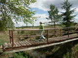 |
A small and forested territory with sulphurous springs, among which the most popular one is the Ellīte sulphur spring. It has sulphurous water with a low level of minerals, and the water supposedly has medicinal properties. The area around the stream is well-appointed, and a pathway leads to it. The stream is considered to be the source of the Iecava River. The restricted area is there to protect biotopes and protected plants which are in the area.
|
|
 |
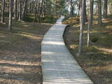
This restricted area was established to protect a high-type swamp, a swampy forest and a series of rare birds. The Niedrāji-Pilka swamp can be crossed with dry feet while enjoying almost virginal nature. This is possible on the narrow-gauge railroad embankment which runs through the swamp for three to four kilometres from the North-east to the South-west, or on the well-appointed circular wood pathway which is on the eastern size of the embankment.
|
|
 |
One of the most distinct sub-glacial depressions in Latvia, with 11 lakes of various sizes and depths. This is a magnificently lovely territory, with particularly good views from the Drusku castle hill. On a clear day, one can even see the Hanja highlands of Estonia. The restricted territory was set up to protect boreal and hillside forests I the area.
|
|
 |
Dabas liegums atrodas dienvidaustrumos no Lubāna ezera un tas veidots purva un meža biotopu un tajos esošo sugu aizsardzībai. Gar teritorijas ziemeļu robežu iet Nagļu - Degumnieku ceļš (iekļaujas kopējā Lubāna dambju sistēmā), pa kuru apkārt Lubāna ezeram izveidots velomaršruts. Tas nozīmē, ka teritoriju var aplūkot arī "no malas", netraucējot tās dabiskās norises. Teritorija ietilpst arī Lubāna mitrāja kompleksā.
|
|
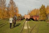 |
Sedas purva kājnieku maršruts atrodas dabas liegumā Sedas purvs, pārgājienu pa maršrutu iespējams apvienot ar Sedas pilsētas apskati, kas ir unikāls 20.gs. 50.–60. gadu pilsētbūvniecības un arhitektūras paraugs - kūdras purva strādnieku pilsēta. Maršrutam ir divi apļi - Jērcēnu aplis - 5,5 km un Sedas aplis - 4,2 km. Tajos apakatāms izstrādātais kūdras purvs, šaursliežu dzelzceļš, ritošais sastāvs, divi skatu toņi. Rudenī un pavasarī - putnu migrācijas lāikā - interesanta vieta putnu vērošanai. GPS koordinātes: Jērcēnu puses aplim: 57.7055987, 25.7001324; Sedas puses aplim: 57.6699587, 25.7514815. |
|
 |
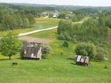
The Kaļķupe River valley was established as the Pilsupe River (formed by Kaļķupe River and Mazupe River) crossed the Blue hills of Šlītere to the South of Vīdale and Kaļķi. The distinct river valley has a branched network of gullies in which Devonian sandstone has been uncovered and can be seen in some locations. Puiškalns Hill (located at confluence of Kaļķupe River and Mazupe River), which was used as a castle hill and as a sacred location long in the past, is one of the most distinctive parts of the area. It is a popular tourist destination in the Talsi District. Hillside forests, various kinds of meadows and a wide range of plants are also of value in the local environment. |
|
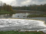 |
The recently renovated old brick bridge and the viewing area that is on the left bank of the Venta beyond the castle guard’s hut offers a lovely view of the widest and most impressive waterfall in Latvia – the Venta falls. It is worth visiting during the spring floods, when fish are migrating.
|
|
 |
There is no need to enter the bog to see it, there are good views from the highway Ventspils – Riga (77 km, bus stop “Pagrieziens uz Elkskeni”). The main value of restricted area is chalky fen bog with brown bog-rush (greatest habitat finding in Latvia). Be careful when stopping on the highway – mind the traffic! A couple of kilometers towards Riga, on the right side of the highway, there is sign to Grizu Velna kresls ( Grizu Devil Chair) which is an attractive boulder (protected).
|
|
 |
Plieņciema taka atrodas dabas liegumā "Plieņciema kāpa" starp Plieņciemu un Ķesterciemu. Pāri kāpai ir izveidota laipu taka un atpūtas vieta. Taka ir izveidota, lai mazinātu negatīvo ietekme uz Plieņciema kāpas dabas vērtībām – zemsedzes nomīdīšanu, piegružošanu ar atkritumiem, braukšanu ar autotransportu.
|
|
 |
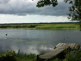
Most of this restricted area is made up of a shallow and eutrophic body of water in which many species of birds, including some that are rare and protected, nest. Specialists say that anywhere between 150 and 450 pairs of black-headed gulls nest in this area on a regular basis.
|
|
 |
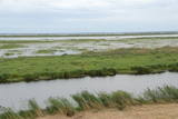
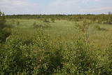
This is a large set of coastal meadows, ancient rivers and areas of reeds. It is found at a location where the Daugava River used to flow – between Vecmīlgrāvis and Vecāķi. There are inland dune meadows here, complete with the very rare silver grass. Vecdaugava is an important location for nesting birds and several uncommon plant species. On the southern end of the Vecdaugava peninsula, at a place called Skanstnieki, one can find remnants of medieval Swedish fortifications. The Vecdaugava Regional Research and Fishing Museum is here, as well.
|
|


