
| No | Name | Description |
|---|---|---|
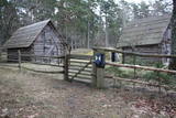 |
Approximately 200 metres to the North-East from the Liv People's Centre, along the Mazirbe-Košrags road, there is the Seppes homestead. The little log granary was built in the 1920s and 1930s by an Estonian fisherman and builder who arrived in Mazirbe from Saaremaa. He was called Jēkabs Jaga. On the other side of the road is the Kalši home, which was built in the early 20th century. It has been restored, but the bricks that were made in a local kiln were preserved for its walls. |
|
 |
Atrodas Tērvetē, Dobeles – Elejas ceļa malā, 0,2 km dienvidrietumos no Tērvetes pilskalna. Ar mežu apaugušais paugurs ir sena apmetnes vieta, kas bijusi apdzīvota jau 1. g.t. pr. Kr. Teika stāsta, ka kalnā bijis klosteris, kura mūki pēc klusēšanas pārkāpuma saulgriežu laikā kopā ar visu celtni nogrimuši kalna dzīlēs. |
|
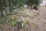 |
A place fraught with many legends and ghost stories about the old burial mound at the church of Mazirbe, an ancient tomb covered by stones– the only known grave of warewolves in Latvia. |
|
 |
Atrodas 0,3 km ziemeļos no Vecpiebalgas pilsdrupām. Ap 10 m augsto, bet visnotaļ izteiksmīgo Grišku kalnu sauc arī par Piebalgas, Balgas un Veļķu pilskalnu. 13. gs. šeit bijusi svarīga apmetnes vieta ar mākslīgi nostāvinātām nogāzēm un dziļu aizsarggrāvi. Vēstures notikumi ir atstājuši ap metru biezu kultūrslāni. Bezlapu laikā no kalna paveras skats uz Vecpiebalgas baznīcu un pilsdrupu vietu. Pilskalna piekājē ir aka ar Griškavotu. |
|
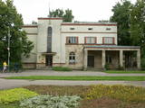 |
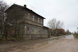
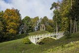
The building was erected during the first period of Latvian independence, and it maintained its functions for a long time. The building is located at Tukuma Street 30. Beginning in 1940, the post office had an automated telephone central. The Postal Service no longer uses it, and the building can only be viewed from the outside. |
|
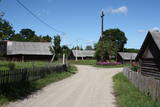 |
Musteikas pirmsākumi ir meklējami jau 18. gs. Līdz Musteikai no Marcinkones puses var nokļūt pa grantētu ceļu, kas ved gar bijušajiem kolhoza zivju dīķiem. Automašīnu var atstāt ciema sākumā un izstaigāt to ar kājām, izjūtot veco ēku smaržu un šarmu. Musteikā atrodas Dzūkijas biškopības vēsturei veltīts „dzīvs” muzejs, kur stropos dzīvo bites, bet tā saimnieks ir biškopis pēc aicinājuma un būtības. Ja palūgsiet, viņš demonstrēs – kā ar krama, metāla un posas piepes palīdzību senos laikos ieguva uguni. |
|
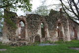 |
Lullemē atrodas blakus parka robežai, bet arī šo vietu ir vērts pieminēt kā vienu no apskates objektiem. Lullemē uzmanību piesaista viena otrai blakus stāvošās baznīcas. Mūsdienās redzamās 15. gs. celtās Sv. Marijas baznīcas drupas ir liecinieks 2. pasaules kara notikumiem, kad 1944. g. baznīcu sagrāva. Jaunā baznīca ir celta 1997. gadā. Ciema rietumdaļā uzstādīts piemineklis, kas veltīts brīvības cīņās (1919. – 1920.) kritušajiem. |
|
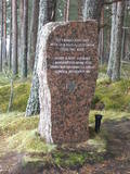 |
Around 6 km in length and an isolated route stretching between Ragaciems and Klapkalnciems where, as stories about olden days tell, robbers used to attack travelers. Around 1.5 km before Klapkalnciems (going from the side of Ragaciems), in the dune by the sea there is installed a commemorational stone dedicated to the Finnish jaeger battles. It was installed on December 09, 1997. The stone has "travelled" from the south-eastern part of Finland where in 1940 it served as an anti-tank defense. In the monument, there are engraved the words, "Here during World War I, from August 1916 to December fought the Finnish yeagers". In turn, in Klapkalnciems there is installed a commemorational stone in the place where there are buried five Finnish soldiers. |
|
 |
This is an ancient and important place for trade and craftsmanship on the left shore of the Rīga hydroelectric power plant reservoir. It rises some 15 m above the Daugava River. The Zemgale port that is described in historical documents is thought to have been located alongside the castle hill and at the mouth of the little Varžupīte stream. Antiquities that have been dug up here suggest that the castle hill and its adjoining ancient settlement were populated until the late 12th century, when the importance of Daugmale began to shrink because of rapidly growing Rīga. The foundations of the castle hill have been shored up. |
|
 |
Setomaa in South-East Estonia is a unique area for its people (the Seto) and culture. The historic location in the borderland between East and West, straddling two languages and cultures has shaped the local language, life style, clothes and food. A very specific type of singing – leelo – is incorporated in the UNESCO list of Masterpieces of the Oral and Intangible Heritage of Humanity. |
|
 |
The Cemetery of the Brethren of
Lāčukrogs offers a final resting place to
men who fell during World War I.
|
|
 |
Salos, Vaišnoriškė, Strazdai, Šuminai sind die bewohnten Dörfe im Augštaitija- Nationalpark, in denen historische Einzelgehöfte mit Holzgebäuden erhalten sind. |
|
 |
One of the biggest castle hills in Estonia, which is surrounded by walls built of stone. It is mentioned in Livonian Chronicle of Henry as one of the best fortifications at that time. |
|
 |
The historic stone, on which there is carved over 200 years old boundary-mark, sets the border between the Duchy of Courland and the Russian province. Nowadays, it sets the Babīte and Jelgava district boundary. The stone lies to the East of Kalnciems–Peat road (the south of the swamp Labais purvs) at the edge of a forest firebreak and it can be hard to find. To this end, the description of the road map may help: around 400 m south of the car parking lot at Lily Lake from Kalnciems-Peat road to the right (in the east) turns a forest road which leads down from hills Krāču kalni. It should be around 170 m to go until it abruptly turns to the right (to the southeast). Then you must go in this direction until after ~ 0.5 km to turn to the northeast where after further ~ 0.4 km of the current forest road intersection turn to the north. After ~ 0.4 km turn right (to the east) on a big firebreak, on the left (the north) side of which behind the drainage ditch during the non-leaf period there can be seen a rounded stone. Due to the poor condition of roads, the stone can be reached only on foot. |
|
|
|
(V-1279) linked Kuldīga and Alsunga before a new road was built. The lovely gravel road weaves through forests and farmland. During appropriate weather, it can be used as an alternative road to learn about the landscapes of the Suiti region. You can also bike down the road. |
|
 |
The biography of Krišjānis Valdemārs tells us that during the summer of 1839, teachers and students from the Lubezere school spent a few days on the coastline in Roja, where Valdemārs would later help to build a maritime school. The area was breath-taking and unforgettable for the little boy. “The noble appearance of the sea grabbed the spirit of the young man so powerfully that during those three days, I thought about nothing other than the noble sea, with childish courage that allowed me to prepare a plan for a deeper port in the Roja River so that larger boats and small ships could enter it,” Valdemārs wrote. (Source: Roja TIC) |
|
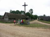 |
Ein der ethnografischen Dörfer in Dzūkija mit Holzgebäuden und Kruzifix. |
|
 |
Taisnā Celtnieku iela ir bijušās Liepājas – Aizputes šaursliežu dzelzceļa (celta 1900. gadā, 49 km gara) līnijas „trase”, kuras malā (Celtnieku ielā 50) redzama bijusī dzelzceļa stacijas ēka. |
|
 |
Temple Hill is steep (with artificially created steepness) and about 30 m high, and it is opposite Marijas Island. It is an ancient Lettigalian castle hill, 80 m long and 40 m wide, with several artificial ramparts. One of the oldest objects found in the region is an axe from the 2nd to 3rd millennium BC. Archaeologists believe that the island was populated at that time. There was a Lettigalian castle on the hill during the 10th and 11th century, but it was sacked by the Holy Crusade. The surface of the castle hill was transformed comparatively recently in 1807, when a granite rotunda was built there in honour of Russian Field Marshall Sheremetev and Swedish captain Wulff. The view of Lake Alūksne and the town is one of the most beautiful ones in all Vidzeme. The Sun Bridge (1937) is also worth a look. A wooden viewing platform is nearby. |
|
 |
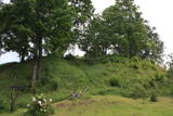
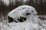
This may be an ancient cult object, and today it is a little hill in the dunes that is a bit larger than other local hills. It is said that a church once sank into the dune. This tale suggests that there was a Christian or pagan prayer place here at one time. (Source: Roja TIC) |
|

