
| No | Name | Description |
|---|---|---|
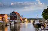 |
The former Memele. The only port city with a old town in Lithuania. |
|
 |
Madona is probably the only town in Latvia, in whose area a lake settlement was located around the 9th century. Its residues are preserved in the northern part of Salas Lake (Baznicezers) under water. Until the end of 19th century, a small estate with the same name (Madona) was located in place, where present town is located, Latvians called the place Bizi. In 1898 construction of narrow gauge railway between Stukmani (Plavinas) and Valka was started. The development of railway helped the development of the town. Today Madona is well maintained Vidzeme town with its own charm typical for small town. Interestingly that it can also be considered as one of the most highly placed towns in relief of Latvia. |
|
 |
The history of Cēsis begins at the Riekstu hill, which is 18 m high and the surrounding area. There was a wooden castle built by the Vendian tribe that stood there from the 11th to the 13th century. The hill is in the central part of the castle’s park, and it offers a fine view of the park, a pond and the ruins of the Cēsis Castle. A long staircase leads to the hill. The Cēsis Castle was built in the early 13th century as the residence of masters of the Livonian Order, and it was one of the most fortified forts in the Baltic region. Alongside is the New Cēsis Castle, which was built in 1777 in a place where gate fortifications had been before. The building houses the Cēsis Museum of History and Art, and an annex contains the Castle Visitor Centre and the Cēsis Tourism Information Centre. From the tower of the castle, we get a good view of the castle ruins, St John’s Lutheran Church and the northern stretches of the city. Opposite the new castle is the stable of the Cēsis Castle Estate and a wheelhouse (both from the first half of the 19th century). Today these house the Cēsis Exhibition Hall. Other buildings include a granary, a hut for coachmen and an old brewery. On the other side of the street is the romantic May park, which was installed during the 1830s. Streets in Cēsis include Lielā Katrīna, Mazā Katrīna, Mazā Kalēju, Kalēju and Lielā Līvu streets and Līvu square with wooden buildings from the late 18th and early 19th century. Torņa Street stretches along the walls of the Medieval castle. Outside the church is a sculpture, “As the Centuries Pass By,” and legend has it that anyone who rubs the lantern of the Old Time Man can see the future. One of the most impressive buildings in Cēsis is St John’s Lutheran Church, which was built in the late 13th century by the Livonian Order. The Roman-style three-segment basilica has elements of Gothic design and a 65 m steeple that was installed in 1853. The building was reconstructed several times during the 20th century and contains grave plaques relates to masters of the Livonian Order and local bishops. The pulpit dates back to 1748, the oak altar was manufactured in 1858, and the altar painting “Crucified One” was painted in 1862. The windows of the altar part of the church contain artistically valuable stained glass. The organ was manufactured in 1907 by the E.F. Walker firm, and it is one of the best concert organs in Latvia. The solar clock with the number 1744 is in the south-wester corner of the church. It is worth scaling the viewing tower of the church. At its foot is Rose Square, which was a market square from the mid-13th century until 1927 and was restored in 2008. This is the central square in the city. During the Middle Ages, a punishment pole and the city well were here. Rīgas Street has been the main street in the old part of the city from the very start, and here we find most of the architecturally distinguished buildings from the 18th and 19th century – the former city hall, the Fābers house and the Princess house. At one end of the street is Liv Square, where there a church, cemetery and the Rīga gate in the city’s walls existed in the 13th century. Today the square is decorated by a lighted fountain at a place where a well was found in the 13th century. On the other end of the street we find a reconstruction of the foundations of the Rauna gate from the 14th and 15th century, offering a good look at Medieval walls and the size and strength of the gates. It is commonly claimed that the national flag of Latvia was born in Cēsis, but it must be emphasised that the flag that is mentioned in chronicles was designed in Cēsis in 1279 as the ideological prototype of the current Latvian flag, while the story of the first national flag actually comes from Valmiera, where it was sewn in 1916. |
|
 |
The Old Town of Kandava is located around the old Market Square and dates back to 1881, after a fire in the town. The urban environment in Kandava is made up of farms with various buildings, closed yards, passageways and walls made of fieldstones. These can be seen in Talsu Street and Sabiles Street. Uncommon for Latvia is Lielā Street. At the foot of the Bruņinieku Castle Hill is a model of the Castle of the Livonian Order that was created in 2010. |
|
 |
Ein ehemaliges Fischerdorf am Ufer des Kurischen Haffs. Hierher sind die Bewohner der Dörfern umgezogen, deren Dörfe unter dem Sand der Wanderdünen begraben wurden. Holzbebauung des 19 – 20 Jh. |
|
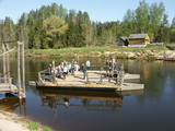 |
Ligatne history is inextricably linked to Ligatne paper mill. At the end 19th century and beginning of 20th century here was built houses, schools, maternity homes, hospitals, clubs, guest houses and other buildings for workers that have survived to the present. During the Soviet period Ligatne mill produced mainly school exercise books, which was sent to all the Soviet republics. Nowadays, the main raw material is recovered paper used for production of wrapping paper. Ligatne paper mill is the only one functioning Latvian company of this kind, and it can be explored with a local guide. Historic centre of Ligatne paper mill has been awarded the status of cultural monument. In the northern part of Ligatne - Gauja river bank the only functioning Gauja river ferry can be found and the only river ferry in the Baltic States, which is powered by river current. The ferry is vehicle of local scale. In the west of Ligatne, Ligatne nature trails are located; where close to natural environment conditions (the best object of this type in the Baltic States) lives red deer, roe deer, wild boar, fox and lynx. Within the territory of Ligatne nature trail a dense network of hiking trails and paved road - cycling route has been created, during the winter it becomes a cross-country ski track. A modern visitor centre is available here. East of Ligatne at Ligatne rehabilitation centre a unique place on the Europen scale can be found - a former Soviet secret bunker that was built as the main living and working place of Latvian senior military and civilian persons in case the nuclear or chemical weapons were used. Bunker was opened in 2003; therefore it remained intact to this day. On the way from Augsligatne to Ligatne go to see Vienkoci Park, where you can explore boats made of single wood peace by the creator of Park Richard Vidzicka, look at the different building models, sand home, and participate in themed activities. |
|
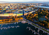 |
Helsinki is the capital of Finland and the biggest city in Finland. It offers a lot to see as it is seaside city surrounded by islands but city itself is full of wonderful parks. This city has everything to attract all kinds of people - from architecture and culture to nature and even has wide range of places where to enjoy night-time Helsinki. |
|
 |
Ja mērķis ir savākt pilnvērtīgu etnogrāfisko ciemu fotokolekciju, ir jāapskata Strazdi (no lietuviešu valodas strazdai tulkojumā nozīmē strazds), kas ir pavisam neliela apdzīvota vieta Balošas (Baluošas) ezera ziemeļu krastā. Strazdi pirmoreiz rakstos minēti 1783. g. un ciema nosaukums cēlies no kādas mežziņu dzimtas uzvārda. |
|
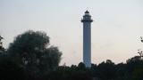 |
(formerly Pize and Pizā in Livonian). The current name of the village comes from a lighthouse (Mihailovskii majak) that was built during the age of the Russian Empire and named for the nephew of Tsar Alexander II. The lighthouse that is there now is the third one to be built on the site. It was built in 1957 and is the highest lighthouse in Latvia (57 m, can only be viewed from the outside). The Lutheran church in Mikeļtornis was built in 1893, and nearby is the Pize Saloon (1857), which is terrible condition. The saloon has a typical design from the 19th century and is the only venue of its type on the Livonian coastline. The first Livonian cultural activist, Jānis Princis (1796-1868), was born in Miķeļtornis, and he and son Jānis translated the Gospel of Matthew into the Western Livonian language. The two of them also wrote a collection of poetry, "Holy Songs and Prayers for Sailors." The only poetry book in Latvia prior to that was published by Blind Indriķis. A student of Vilhelms Purvītis, Livonian painter Andrejs Šulcs (1910-2006), was born at the Olmaņi homestead in Miķeļtornis. A monument to Livonian poets was installed at the local cemetery in 1978 and was the first monument dedicated to Livonians. There are plans to open an environmental object by artist Ģirts Burvis, "Century of Sailing Ships", in 2019. |
|
 |
Third biggest island in Estonia. Full of beautiful grown junipers, little dolomite outcrop on the coast of the sea and fishermen villages on the coastline. |
|
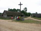 |
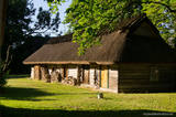
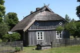
Ein der ethnografischen Dörfer in Dzūkija mit Holzgebäuden und Kruzifix. |
|
 |
Haapsalu was once loved by aristocrats who stayed here during summers, nowadays this town is very appealing to its visitors because of its essence - tiny streets, old wooden buildings and promenade. Worth mentioning are also town's SPAs which were one of the reasons why Haapsalu was so popular its earlier years. Interesting enough, the famous composer Tchaikovsky considered this place one of his favorite's for spending the holidays. |
|
 |
The town of Subate was first listed in documents in 1570, when Duke Gotthard Kettler of the Duchy of Courland sold the Subāte marketplace to Count G. Plater-Sieberg. When the Plater-Sieberg dynasty converted to Catholicism in the mid-17th century, Lutherans in Subate protested by moving to the eastern bank of Lake Subate. That was the property of the Prode Estate (only ruins remain at this time), which was owned by the Osten-Sacken dynasty. In 1685, the Osten-Sackens built a Lutheran church for the “refugees,” and Jaunsubate was established around it. Both parts of the town were merged again in 1894. During Latvia’s liberation battles in 1919, Subate was liberated by Lithuanians, at which time the town was divided up between Latvia and Lithuania (though the border between the two countries was set at the previous line in 1921). The historical centre of Subate was established between the 16th and the 19th century, and it includes four churches for various congregations and low wooden buildings which stretch along narrow and curvy streets. The town is on the shores of a sub-glacial depression with Great Lake Subate and Lesser Lake Subate therein. This provides the town with unusual landscapes for Latvia. |
|
 |
Истоки площади Роз уходят в 1911 - 1913 гг., когда на этом месте разбили открытый сад с > 500 кустами роз. В советское время рядом с площадью Роз был установлен памятник Ленину. Восстановленную в 2000 году площадь окружает Лиепайская Педагогическая академия, гостиница «Лива», Центр бизнеса и сделок De Rome (построен в XIX веке, архитектор Пауль Макс Берчи, бывшая гостиница «Рим») и Лиепайский дом латышского общества (камень в основание заложил Карлис Ульманис в 1934 г.). По бордюрам грядок роз размещены памятные знаки городов содружества Лиепаи. К площади Роз подходит улица Зивью (Рыбная), получившая свое название от когда-то существовавшего рыбного рынка. На улице Зивью находится Аллея славы латвийских музыкантов (с 2006 г.), где установлено 35 плит с бронзовым рельефом ладоней музыкантов, 10 плит, посвященные популярным латвийским музыкальным группам, а 5 – ушедшим в мир иной. Здесь же установлена самая большая гитара Латвии. |
|
 |
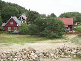
Koņuciems of Pape is one of the few seashore fishing villages in Latvia to have preserved an authentic environment to the present day. The Latvian Open-Air Ethnographic Museum has a branch here, “Vītolnieki”, and this is an authentic and ancient fisherman’s farm. +371-2926-2283. The sad fact is that some people have built modern buildings in the village, and it has now lost its earlier untouched charm. |
|
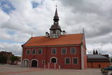 |
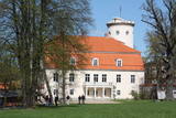
In 1615, Courlandian Duke Friedrich Kettler (1569-1642) allowed Bauska to build a new city hall. At the beginning of the 17th century, Market Square in Bauska featured the largest city hall in the entire duchy. A lack of money led to the dismantling of the hall’s tower in 1852 and its second floor in 1871. A new city hall was built in 2011, and now Bauska can be proud of a new and outstanding tourist destination that can also be entered. The restored city hall offers a chance for people to weigh themselves and measure their height with old-time measurements. Each person who does so receives a certificate to attest to his or her height and weight. |
|
|
|
Together with Valga on Estonian side - a peculiar frontier twin town. |
|
 |
Ļoti skaists un ainavisks etnogrāfiskais ciems Balošas (Baluošas) ezera ziemeļu krastā, netālu no diviem iepriekš minētajiem ciemiem. Te apskatāmas interesantas un skaistas koka ēkas, kas celtas no guļbaļķiem, ar niedru vai lubiņu jumtiem un izrotātas ar dažāda veida dekoratīvajiem elementiem. Pirmo reizi rakstos Šumini minēti 1784. g. Savu vārdu ciems ieguva no kādreiz dzīvojošas ģimenes uzvārda. Kā interesantākā ir jāpiemin sena klēts. |
|
 |
Die zentrale und auch schönste Straße in Trakai mit bunten Holzhäusern. Eins der seltenen Kenesa-Gebetshäuser der Welt – ein eingeschossiges Holzhaus mit einem bläulichen Dach. |
|
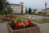 |
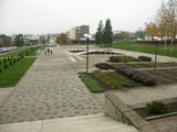
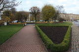
Madonas centrālais laukums, kas vēl 20. gs. sākumā bija tirgus laukums. Pēc apjomīgās restaurācijas tas ir kļuvis par ievērības cienīgu pilsētvides objektu. Laukuma ziemeļu pusē atrodas pilsētas un novada pašvaldība un Madonas novada TIC. |
|
