
| No | Name | Description |
|---|---|---|
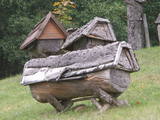 |
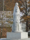
Das bekannteste Museum der Geschichte der Bienenzucht Litauens mit den Bienenhäusern verschidener Arte, der Arbeitsmittel der Bienenzüchter, Holzskulpturen und Hönigankauf. |
|
 |
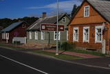
Together with Valga on Estonian side - a peculiar frontier twin town. |
|
 |
An ancient territory inhabited by Livs already since the 5th – 6th century. In 1226 Bishop Albert built a castle on the right bank of Salaca river estuary, which has not been preserved until now. Salacgriva development also (similar to Ainazi) has been associated with the establishment of the port in the turn of the 19th – 20th century. Salacgriva became an important handling and transport hubs of products manufactured in Northern Vidzeme (especially timber). During the Soviet period, in the Northern part of Salacgriva established the Fishermen Park with one of the best small town stadiums and open air stage. During that time, the products of fish processing plant "Brīvais vilnis" was well known in the territory of USSR - especially sprats. Salacgriva is one of the two places in Latvia, where the weirs are still used for lamprey fishing. |
|
|
|
Одно из сравнительно редких мест, где на побережье можно понаблюдать за рыбаками в работе. Ветряная мельница «Клаюми» (1930 г.) является одним из самых высоких сельских строений. Рядом с мельницей находится Юрмалциемский Туристический информационный пункт, информационный стенд и место для отдыха.Здесь же видны старые деревянные корпуса барж, брошенных рыбаками. Экспозиция«Старинные предметы жителей Юрмалциемса» находится в восточной части поселка, где в деревянном сарае представлены собранные местными энтузиастами предметы быта и орудия труда окрестных жителей. |
|
|
|
Kaļķis is a populated area where
dolomite is still extracted from quarries in
the region (Kalnciems2 is one such
quarry). Some of the quarries are flooded.
|
|
 |
Materials of archaeological excavations show that the Ogre river banks were inhabited by the Livs. Ogre as a larger populated area and a major resort developed after the construction of Riga-Daugavpils railway in 1861. Until the World War I about 300 cottages offered their services in Ogre, most of them were destroyed during the war. The next "major" event took place 1965 when one of the largest knitwear plants in Europe was built in Ogre, which was staffed by guest workers from Vietnam and countries. Today, Ogre has still not recovered its glory of a resort, but has become a rather exclusive site of mostly low-rise residential buildings. |
|
|
|
One of the oldest towns in Latvia, about which data can be found already beginning from 1378. As a populated area it formed at the banks of the Tebra River (the side of Riga-Prussia road), where once the fortified wooden castle Beida of the Cours Land Bandava was located. In the medieval times Aizpute was the centre of Kurzeme bishopric. After joining Kurzeme to Russia in 1795, Jews settled for living in Aizpute. Today travellers in Aizpute are most attracted by the ancient city environment that is still alive here, as well as by the historical centre of the city and the castle ruins. |
|
 |
Seda is one of the most unusual towns in Latvia. It began its life as a housing area for people from the local peat moss factory, and that happened in the 1950s and 1960s. This is a “vivid” example of Soviet architecture, with a central square (complete with a monument to the Leader) and streets radiating from it. Worth a visit is the cultural centre at the end of Uzvaras Street. It is a great example of so-called Stalinist Classicism architecture. |
|
|
|
Pilsētas rajons dienvidos no Ventas grīvas, kura mūsdienās redzamā mazstāvu koka apbūve sāka veidoties 19. gs. vidū. Ostgala pirmsākumi meklējami 1836. g., kad Krievijas valdība, solot priekšrocības, aicināja apkārtnes zvejniekus apdzīvot smilšaino un kustīgo kāpu pārņemto piekrastes daļu. Ostgals ir atzīts par valsts nozīmes pilsētbūvniecības pieminekli. |
|
 |
Dobele name in historical sources for the first time is mentioned in1254. Dobele was one of the most fortified Semigallian places; therefore from 1279 until 1289 it survived six attacks by German crusaders. In 1289 Semigallians was forced to retreat. In 1335 conquerors instead of Semigallian castle began construction of new - stone castle. On the opposite shore of Berze - on the left bank merchants and craftsmen village began to form. Town suffered greatly during the Northern War and during the subsequent plague. A significant event in the economic life was the 1927, when Liepaja-Gludas railway line was built. After World War II in Dobele and its vicinity came to the Soviet militaries, who built one of the largest Soviet tanks range "Dobele-2". Now Dobele travellers are offered a range of interesting sites to be visited. |
|
 |
The central part of the town of Krāslava is an historical monument because its low-story and beautiful wooden buildings. The best views of the historical centre relate to the carp park near the Adamova trail, the Karņicskis hill, the bridge across the Daugava (Prospekta Street), and the Priedaine viewing tower on the left bank of the Daugava River. |
|
 |
The Old Town of Kandava is located around the old Market Square and dates back to 1881, after a fire in the town. The urban environment in Kandava is made up of farms with various buildings, closed yards, passageways and walls made of fieldstones. These can be seen in Talsu Street and Sabiles Street. Uncommon for Latvia is Lielā Street. At the foot of the Bruņinieku Castle Hill is a model of the Castle of the Livonian Order that was created in 2010. |
|
|
|
Entstanden als eine 6 km entfernte Arbeiterstadt des schon geschlossenen Ignalina-Atomkraftwerks. In der Stadtbebauung dominieren die für die Sowjetzeit typischen architektonischen Formen und Monumentalbauten. |
|
 |
From the 6th century until the 8th century instead of the current Grobina the largest known Scandinavian trade and warrior colony in the Baltic States was located. Settlers from the inlands of Gotland and Sweden established their settlement at the hillock that was then located at the bank of the navigable Alande River. It is believed that the Cours Castle – Seeburg mentioned in the chronicles of the 9th century was located exactly here. After the loss of the order castle in the 13th century Grobina became the centre of the region. The most ancient construction of the city was formed around Lielā Street, as well as around Saules and Parka Streets. |
|
 |
Vēstures avotos pirmoreiz minēta 1483. g. Pilsētas uzplaukums bija vērojams pēc dzelzceļa uzbūvēšanas 19. gs. beigās, kad barons Korfs sadalīja un iznomāja apbūvei muižas zemi. Pilsētas tiesības Priekule ieguva 1928. g. Pilsēta smagi cieta 2. pasaules kara pēdējos mēnešos, - t.s. Kurzemes katla laikā, kuru laikā tika sagrautas 410 no 450 ēkām. Mūsdienās tā ir neliela pilsētiņa ar mazstāvu apbūvi un nesteidzīgu dzīves ritmu. |
|
 |
Maza apdzīvota vieta ar dažām viensētām uz pussalas (salos tulkojumā no lietuviešu valodas nozīmē „sala") starp vairākiem ezeriem. Salos II ir viens no sešiem Augštaitijas nacionālā parka etnogrāfiskajiem ciemiem. Ciems patiks tiem, kas meklē ļoti nomaļas vietas ar vecām guļbaļķu dzīvojamām un saimniecības ēkām. No Salos II pa sauszemes maršrutu var doties pārgājienā līdz Ladakalnim un Ginuču pilskalnam (sk. iepriekš). |
|
|
|
The town of Subate was first listed in documents in 1570, when Duke Gotthard Kettler of the Duchy of Courland sold the Subāte marketplace to Count G. Plater-Sieberg. When the Plater-Sieberg dynasty converted to Catholicism in the mid-17th century, Lutherans in Subate protested by moving to the eastern bank of Lake Subate. That was the property of the Prode Estate (only ruins remain at this time), which was owned by the Osten-Sacken dynasty. In 1685, the Osten-Sackens built a Lutheran church for the “refugees,” and Jaunsubate was established around it. Both parts of the town were merged again in 1894. During Latvia’s liberation battles in 1919, Subate was liberated by Lithuanians, at which time the town was divided up between Latvia and Lithuania (though the border between the two countries was set at the previous line in 1921). The historical centre of Subate was established between the 16th and the 19th century, and it includes four churches for various congregations and low wooden buildings which stretch along narrow and curvy streets. The town is on the shores of a sub-glacial depression with Great Lake Subate and Lesser Lake Subate therein. This provides the town with unusual landscapes for Latvia. |
|
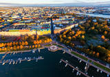 |
Helsinki is the capital of Finland and the biggest city in Finland. It offers a lot to see as it is seaside city surrounded by islands but city itself is full of wonderful parks. This city has everything to attract all kinds of people - from architecture and culture to nature and even has wide range of places where to enjoy night-time Helsinki. |
|
 |
On the right bank of the River Pēterupe is one of the historical areas of Saulkrasti – Pēterupe Village. It is believed that the village began to form around a chapel during the so-called Swedish or Catholic times. The chapel was named after the Apostle St. Peter, and therefore the river and the village also carries his name. Pēterupe Village can be considered the oldest village in the Saulkrasti region. The oldest witnesses of the origin of Pēterupe Village are: Rectory, Pēterupe Evangelical Lutheran Church, Outpatient Clinic and the wooden buildings in the old village centre. |
|
 |
Old Town Square is the city’s historic centre. It was here, on February 12, 1670, that Duke Jacob of the Duchy of Courland proclaimed the establishment of a town. During the early 20th century, the square was covered in paving stones, and the city market was held there. On the sites of the square are the People’s Centre, the Unitarian Church and a tourism information centre. In the square are a water pump, an enormous scale, and a sculpture of a cougar, which is the symbol of Jēkabpils. From here you can tour the historical centre of Jēkabpils with its narrow streets and low-story buildings. |
|
