
| No | Name | Description |
|---|---|---|
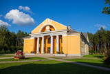 |
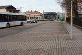
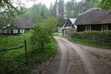
Seda is one of the most unusual towns in Latvia. It began its life as a housing area for people from the local peat moss factory, and that happened in the 1950s and 1960s. This is a “vivid” example of Soviet architecture, with a central square (complete with a monument to the Leader) and streets radiating from it. Worth a visit is the cultural centre at the end of Uzvaras Street. It is a great example of so-called Stalinist Classicism architecture. |
|
 |
Known as Alšvanga in the past, this place was mentioned for the first time in 1231 in an agreement that was signed between the deputy legate of the pope in Rome and the Courlandian tribes of the region. The Livonian Order ruled the territory until 1561, and from 1573 until 1738 the order’s castle belonged to the von Schwerin dynasty from Pomerania. It during the rule of this aristocratic family that a stone church was built in honour of Archangel Michael, and local residents began to convert to Catholicism. Alsunga became the Catholic centre for all of Kurzeme, and local residents became known as the Suiti (from the Schwerin suite). For nearly 400 years, Alsunga has been the historical centre of the Suiti territory. This is Latvia’s most conservative region and is widely known with unusual songs, colourful folk costumes and various folk traditions and beliefs. The Suiti have their own dialect, foods and many other things that have been long since abandoned or forgotten elsewhere in Latvia. The religious has commingled with the folk here in one unique whole. The Alsunga District covers 191 km2 and has some 1,500 residents. |
|
 |
Ein einzigartiges Örtchen beiderseits des Flusses Minija, wo der Fluss eine „Hauptstraße” ist. Litauens Venedig. |
|
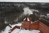 |
Construction of the Sigulda castle was begun by the Order of Brethren of Swords in 1207, but in 1236 it was rebuilt for the needs of the Livonian Order. The building suffered much damage during wars in the latter half of the 16th century and the early part of the 17th century. It was burned down during the Great Northern War and was not restored. Visible today is the south-western wing of the castle’s convent building and the main gate tower, behind which is the internal forecastle with an open-air stage that offers an impressive view of the ancient Gauja River valley. The new Sigulda castle was built between 1878 and 1881, and it was owned by Count Kropotkin. From 1923 until 1940, the castle housed a centre for writers, and during the Soviet Union it was a hospital for cardiology patients. Since 2003, the Sigulda Administrative District Council has been located here. The buildings that have been preserved include a wooden home (mid-19th century), where the Kropotkin family used to live, a granary (late 18th or early 19th century), the home of the gardener (19th century) and a brick wall (19th century). If we go to the north-eastern direction, we will find the Vējupīte valley less than two kilometres away. It includes the shallow (3.6 m) but high (6.1 m) Pēteris cave and the deep Pūču valley with the little Kraukļupīte River. At the place where the two valleys come together we find the Satezele castle hill (its flat surface is 90 x 75 m), where, in the early 13th century, the oak castle of the ruler of Livonian lands, Dabrelis, was once found. Nearby is the Kraukļu valley, with 11 m sandstone walls and a cave that is 5.2 m deep. Nearby is the Paradise (Painter) hill, which offers a lovely landscape that has been painted and photographed since ancient times. There is a Ferris wheel in the western part of Sigulda that is open during the summer, as well as an aerial tram that is the only transport vehicle of its type in the Baltic States and was installed in 1969. The cable that carries the tram is 1,060 metres long and links the shores of the ancient Gauja River valley between Sigulda and Krimulda. The cable is approximately 40 metres above the Gauja. The south-western part of Sigulda features the mighty Beite cliff which is split by a deep stream valley. To the west of the cliff is the Emperor’s View viewing area that is 67 m above the Gauja and offers a good view of Krimulda and the Turaida Castle. A viewing area was established here in 1862, when Tsar Alexander II of Russia visited Sigulda. The wooden Emperor’s chair is to the east of the viewing area. The Turaida Museum Reserve is in the place where the shore is split by deep valleys carved out by streams. It features several outstanding monuments that are as much as 1,000 years old. Of note are the Turaida Estate (21 buildings), the grave of the Rose of Turaida, the Turaida Lutheran Church (1750), which is one of the oldest wooden churches in Latvia) and the Turaida Castle. Folksong hill, which is nearby, is used for various thematic events. |
|
 |
Pavilosta is a comparatively new city that has formed at the mouth of the Saka River in the Baltic Sea. True is the fact that in the medieval times the harbour of sea ships was located 6 km from the sea – at the junction of the Tebra and the Durbe Rivers. Important period in the life of the harbour was during the ruling of Duke Jacob, when sea ships arrived here. As a result of the Polish-Swedish war the Saka harbour had to be closed. The harbour that's visible nowadays in the mouth of the Saka River was formed in the middle of the 19th century at the so called Akagals fishermen village. In 1878 the river mouth was excavated and piers were built. Here two-masted ships were built. The World Wars destroyed the fleet, but the fishery traditions remained alive. In 1991 the populated area acquired the status of a city. Nowadays Pavilsota is a popular target for yachtsmen and windsurfers, as well as summer recreation place. Yachtsmen are awaited at the yacht harbour. |
|
 |
The largest city near the Liv Coastline, where visitors will find the Ventspils branch of the Liv Association and the Liv ensemble "Rāndalist." In nearby Tārgale are the Liv ensembles "Kāndla" and "Piški kāndla." |
|
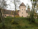 |
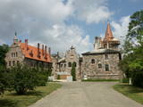
Every traveller in Latvia relates the name of Edole to Edole Castle. The beginning of it dates back to the middle of the 13th century, but the outbuildings of it were constructed in the 16th and 19th centuries, when patio was formed. During reconstruction of the castle implemented in the 30ies of the 19th century the facades of the castle acquired their current – Neo-Gothic appearance. From the16th century until 1920ies Edole Castle was located within the property of a baron family. In 1905 during rebellions it was burnt down, but in 1907 it was reconstructed. Many legends and ghost stories are told about Edole Castle. |
|
 |
Koņuciems of Pape is one of the few seashore fishing villages in Latvia to have preserved an authentic environment to the present day. The Latvian Open-Air Ethnographic Museum has a branch here, “Vītolnieki”, and this is an authentic and ancient fisherman’s farm. +371-2926-2283. The sad fact is that some people have built modern buildings in the village, and it has now lost its earlier untouched charm. |
|
 |
Aizputes pilsdrupas, akmens tilts pār Tebru, Jaunā pilsmuiža, ūdensdzirnavas un Sv. Jāņa luterāņu baznīca, kā arī 19. gs. beigās celtās koka ēkas starp Jāņa, Katoļu un Atmodas ielu veido neparastu pilsētbūvniecības kompleksu, kam piešķirts kultūras pieminekļa statuss. Staigājot pa vēsturisko centru, uzmanība jāpievērš ēku durvīm un to vērtnēm, logu ailēm, balkonu margām u.c. elementiem. |
|
 |
Ap 200 m garajā un izstieptās formas laukumā no 16. – 20. gs. atradās Liepājas tirgus. Laukuma malās tolaik bija izveidojusies vienstāvu apbūve – iebraucamās sētas, viesnīcas un dārzi. Līdz ar Pētertirgus izveidi 1910. gadā, izmainījās arī laukuma apveidi un to ieskaujošā apbūve. Laukuma DA malā slejas iespaidīgā Liepājas Svētās Annas Luterāņu baznīca. |
|
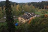 |
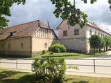
The history of Līgatne cannot be separated from the paper factory which was once the only factory of its kind in Latvia. Tours are available in the company of a guide. During the late 19th and early 20th century, the company built homes, a school, a birthing centre, a hospital, a club, a guesthouse and other buildings for its employees, and most of these buildings have survived to this day. There are more than 200 interesting underground passageways which are still used as warehouses for various items, including vegetables. |
|
 |
This village appears in historical documents from 1310. A census in 1582 and 1583 recorded eight farms in the village, while a 1731 census conducted by the Dundaga Estate found only three. In 1826, each farm had 16 or 17 people, with some 60 in total. A census in 1935 showed that all 49 Livonians in Saunags spoke the Lithuanian language, but only 11 of them spoke the language at home. There was a store that was owned by Kārlis Tilmanis, who also owned a factory where sprats were salted. Also born in Saunags was the seafaring captain Arvīds Ludeviks (1912-1996). In May 1945, he captained a tugboat, the Rota, in an attempt to bring Latvian refugees to Sweden. The ship was detained, and the captain was sent to Siberia. Another seafaring captain from Saunags was Visvaldis Feldmanis (1938-2017). |
|
 |
Cesvaine was first mentioned in written sources in 1209. For each traveller in Latvia, the town is associated with the family of Baron Woolf, who bought the Cesvaine estate in 1815. Cesvaine experienced the economic boom after establishment of Plavinas Gulbene railway. Town suffered significantly during the World War II. At the end of 2002, the Cesvaine Castle was struck by the tragedy - a fire, which damaged most of the castle. Cesvaine Castle is "recovering" by means of large public, state and local government support and still keeps the status as a significant tourism attraction in a scale of Vidzeme and Latvia. |
|
 |
Liela meža masīva vidū gleznainās Būkas (Būka) upes krastos starp kokiem ieslēpies teiksmainais Vaišnoriškes ciems. Šis ir viens no skaistākajiem nacionālā parka etnogrāfiskajiem ciemiem. Vaišnoriške kā apdzīvota vieta sākusi veidoties 1756. g., kad šeit sena vēsturiska ceļa malā darbojies krogs. Pirmā viensēta ciematā ir zināma no 1830. g. Šodien redzamā apbūve ir tapusi g.k. 20. gs. sākumā. Ciems ir palicis cilvēku atmiņās ar liepu medu, jo meža velšu vākšana un biškopība bija viena no galvenajām šejieniešu nodarbēm. Tagad ciemā ir piecas sētas. No Vaišnoriškes var uzsākt laivu braucienu pa seklo un dzidro Būku. |
|
 |
Ancient legends say that ship sank in the sea near the old cemetery during a storm and during a worship service. The pastor and members of the congregation volunteered to use a rowboat to save the crew of the ship. Some of the men were rescued, while others were washed ashore. In honour of this tragic, but also happy solution, the captain called the place Feliksberga, or the Lucky Shore. Later it became known as Pilsberga, and it was renamed Jūrkalne only in 1925. |
|
 |
Die zentrale und auch schönste Straße in Trakai mit bunten Holzhäusern. Eins der seltenen Kenesa-Gebetshäuser der Welt – ein eingeschossiges Holzhaus mit einem bläulichen Dach. |
|
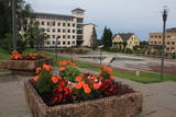 |
Madonas centrālais laukums, kas vēl 20. gs. sākumā bija tirgus laukums. Pēc apjomīgās restaurācijas tas ir kļuvis par ievērības cienīgu pilsētvides objektu. Laukuma ziemeļu pusē atrodas pilsētas un novada pašvaldība un Madonas novada TIC. |
|
 |
Der älteste und größte Kurort Litauens (seit 1794). Mikroklima (Luft der Umgebungswälder), salzhaltigee Quellen, Heilschlamm. Die Altstadt ist ein städtebauliches Denkmal. |
|
 |
This is an ancient Liv village, known as Mustanumm is the last village in the south-easterly direction, and during the mid-20th century, just a few Livonians lived there. Of 307 inhabitants in 1935, only 15 were Livonians. At the beginning of the 19th century, there were six farms and a lagoon here, but at the end of the century there were 63 farms. The valley of the Baķupīte River and the sea had remnants of pilings that provided evidence about a Medieval port. Legends say that the sea robber Trommel had a castle on the left bank of the river during the 14th century. Sailing ships were once built in the region, as well. Two locations of cultural and historical importance in Melnsils are the ancient cult location that is the Baķi castle hill, and the castle hill of a sea pirate Trommel. |
|
 |
Although out of 104 village houses 97 were destroyed during World War I, at the end of the 30ies of the 20th century Lapmezciems "recovered" fast, and one of the most powerful coastal fishermen cooperatives in Latvia were operating in it. During the Soviet times here one of the largest fishery collective farms – "Selga" was founded here, the blocks of which can be seen at the mouth of the Siliņupe River. Today Lapmezciems is a popular area for summer cottages, a recreation and bathing place. As an interesting history monument of fishery the sedum of Lapmezciems is available for viewing – it is the former wharf of fishing boats, where fishermen built nest cabins and stored their equipment. Between Pīlādži Street and the left bank of the Siliņupe River in the 3rd and 2nd millennium BC settlement of fishermen and hunters were located, where a memorial stone is erected. This is the most ancient known location populated by humans within the territory of Kemeri National Park. Part of the findings is displayed at Lapmezciems museum, where local history research exposition is formed and materials about Finnish Jeager fights within the territory of Klapkalnciems are gathered. |
|
