
| No | Name | Description |
|---|---|---|
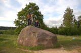 |
The rock is not too big (2.1 m high, 15 m in circumference), but since the early 20th century it has been a popular tourist destination. There is a lovely view of the
|
|
 |
Одна из наиболее высоких дюн нашего побережья. В советское время в дюне велись копательные работы, так как песок использовался для производства силикатного кирпича. В 80-е годы ХХ века копательные работы были прекращены. Самая высокая часть дюны (хороший вид) сохранилась и поросла сосновым лесом. Создана природная тропа горы Пусену. Находятся в Бернатском природном парке. |
|
 |
Here the visitor will find an ecological tourism trail in the ancient Embūte valley. The hills around Embūte date back to the Ice Age. There are valleys and forests of many fallen trees which are protected habitats. The visitor will learn about important natural and cultural monuments – the Embūte castle hill, as well as the ruins of a baronial estate, a castle and a church. The Courlandian chieftain Indulis died in the region. The visitor can view the Devil’s Dam, along with meadows, a viewing tower, etc. There are bicycler routes in the region. The site is located in the Embūte nature park. |
|
|
|
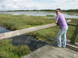
Atrodas Burtnieka ezera austrumu krastā – uz ezera poldera dambja. Pavasara un rudens migrāciju laikā – laba putnu vērošanas vieta. Putni redzami ne tikai ezera piekrastē, bet arī poldera mitrajās pļavās. |
|
|
|
Atrodas mežā, netālu no Kaltenes. Labiekārtota (laipas, kāpnes, informācijas stendi) taka, kas iepazīstina ar Latvijai samērā neparastu dabas pieminekli (aizsargājams) – Kaltenes kalvām, kas ir lieli, līdztekus Rīgas jūras līča krasta līnijai orientēti laukakmeņu krāvumi. Uzskata, ka tos veidojuši Baltijas ledus ezera ūdeņi un ledi. Garums – ap 1,5 km. |
|
|
|
Izteiksmīgs zemesrags, kas klāts ar
dažāda lieluma laukakmeņiem.
|
|
 |
This is about 30 km long territory between the Baltic Sea and the Kolka-Ventspils road. It begins at the mouth of the Irbe River and ends at Ovišrags. The territory was mostly established so as to protect dry coniferous forests, grey dunes, damp areas among the dunes, other landscape features and plants and animals in the area. Distinctive landform - kangari and vigas - and grey dunes are Europe-wide significant habitat. Tourists love the sandy and quiet beaches of the area, as well as the Miķeļbāka and Ovīši lighthouses (it is possible to visit Oviši lighthouse and museum in it) and the Lutheran Church at Miķeltornis. There are also certain leftover elements of the Soviet military system, former narrow gauge railway (railway embankment, former train stations marked by memorial stones etc.) which unfortunately are not used as tourism resources. |
|
|
|
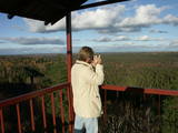
Latvijai neparastā izskata tornis tika uzcelts līdz ar Ziemeļblāzmas kultūras pils un parka atjaunošanas procesu. No torņa paveras plašs apkārtskats uz jau minēto parku, pili, Daugavu, Pārdaugavu un Daugavas vārtiem (Daugavas ieteka jūrā). Darbojas lifts. Tornis atvērts sezonas laikā. |
|
|
|
The cave, which is 45 m deep and up to 5.5 m wide is found on the right bank of the Strīķupe river, by the Cēsis-Lenči road. The cave and its nearby sandstone cliff have suffered much damage from local visitors, which is why the administrators of the national park limited access to the surrounding territory a few years ago. You can no longer approach the cave. This is a positive example of who an important geological monument and a protected biotope can be protected. |
|
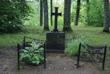 |
To the North of the Cesvaine Castle is a park that is crossed by the rapidly flowing Sūla River. The Cesvaine castle hill is on the northern bank of the river, is around 15 m high and is covered by trees today. The grave of the owner of the castle, Adolf von Wolff, is there. It is said that he wanted to have his casket dragged to the gravesite on a sled. He died during the summer, but that was done anyway. The park features a wide diversity of trees and bushes, some of which the owner brought home from his extensive travels. |
|
|
|
Taka ap Ozolu Mazezeru. Purvaino krastu posmā, ap ezera rietumu galu, ierīkotas gājēju laipas. Novērojami purva, meža un ezera augi, dzīvnieki un biotopi. Jūlija beigās īpaši krāšņi zied ūdensrozes. Blakus atrodas Ozolmuiža ar parku.
|
|
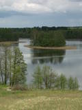 |
In Vecslabada, there is a peninsula among Lake Dziļezers, Lake Audzeļi, and Lake Istra. From the highest point on the peninsula, you will see a truly unusual view of the land of the blue lakes – lake islands, as well as the village of Vecslabada with its church towers. The Lake Istra nature reserve is nearby.
|
|
 |
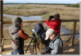
The tower is at the western end of the Seda swamp, accessed from the side of Jērcēni. Transport is limited here. The tower is in the area of the swamp where peat moss is extracted. It offers a broad view of the ponds of Seda and a boat rental facility that is nearby. It is an appropriate location for bird-watching during the season of migration. There is another bird-watching platform near the town of Seda. This is part of the ZBR. |
|
|
|
A diverse stand of forest that is bisected by the Vidzeme highway and the Rīga-Lugaži railroad line. This is a place where the largest endangered bird in the world – the European roller – can be found. Between one-quarter and one-fifth of the Latvian population of the crow is found here. This, too, is one of the last nesting places for the green woodpecker.
|
|
 |
Near the Lielauce manor house start of a wooden pathway which crosses the transition-type swamp that is on the shore of Lake Lielauce to a boating facility near the open part of the lake. Boating and fishing are possible – here, too, the population of fish is regularly restored. The area is a part of the Vīķi swamp restricted zone. |
|
 |
The Slītere National Park (established in 2000) is known, with good reason, as an open-air museum which shows the historical development of the Baltic Sea. Nowadays evidence of geological events is seen in the Blue Hills of Slītere, which stand 20 to 30 metres high above what was the shore of the Baltic lake of ice 10,000 years ago. The Stiebri hills were former 8,000 or 9,000 years ago, while the Littorina Sea formed Europe’s largest set of dune ramparts and damp hollows between those ramparts. This occurred between 4,000 and 7,000 years ago. The gentle climate of Northern Kurzeme is the reason why so many rare plants are found in the park – some 860 in all including Common Yew (Taxus baccata) and Baltic Ivy (Hedera helix var. baltica). Of certain value in the preservation of these treasures was the Soviet military machine, which has left behind army bases and other military objects in the area. The presence of the military meant that the area of what is now the Slītere National Park remained largely undisturbed for 50 years. The park includes one of the most popular tourist destinations in Latvia – the Cape of Kolka, which is visited by more than 50,000 travellers each year. During the spring migration of birds, more than 60,000 birds cross the cape each hour. Along the shore of the Baltic Sea is the so-called Livonian coast, which stretches from Kolka to Sīkrags and Ovīši. Fishing villages and other cultural objects established by the world’s smallest ethnic minority, the Livonians, can be found here. Tourists will enjoy interesting four nature trails, bicycling routes, viewing tower, etc. The visitors centre is located at the Slītere lighthouse. Administration of National park is organising environmental education events on regular basis open to everyone. |
|
 |
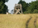
The viewing tower is in the southern part of the reserve, along the Ļaudona-Mārciena road and on the Madona-Trepe embankment. Here you can view a very wide territory all the way to the Vidzeme highlands, including Gaiziņkalns Hill if the weather is clear. At the foot of the tower you will see the lakes known as Small and Great Lake Plencis. |
|
 |
This is one of the largest areas of swampland in Latvia, lying between Lake Babīte and Olaine. Most of the area is still made up of peat. Relatively untouched is the northern part of the swamp, where there is a lovely set of swamp lakes, featuring landscapes of moss swamps. The heath is one of the few swamps in Latvia where the western-type and eastern-type swamp coexist. This is an important location for protected birds. A nature trail and viewing tower are to be installed at the heath in the near future.
|
|
|
|
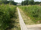
In 2006, a wooden pathway was installed across the Planči swamp – 500m long, which means that the visitor will spend around 20 minutes there. This is probably the only nature trail in Latvia for which there are plans to post information in Braille for people with impaired vision.
|
|
 |
Kaņieris is a seriously overgrown and
shallow seaside lake. Its water level was
adjusted several times during the 20th
century so as to obtain agricultural lands.
The lake has 14 islands, among which nine
are natural and the rest are artificial and
aimed at attracting nesting water birds.
Lake Kaņieris has one of the richest
diversities of birds in Latvia. An
ornithological nature reserve was
established here in 1964. In 1989, the lake
was placed on the list of major birding
locations in Europe, and in 1995 it was put
on the list of the Ramsar Convention. At
the southeastern shore of the lake is a
boating facility (only rented boats are
permitted on the lake). A bird-watching
tower was erected on the Riekstu
peninsula in 2009
|
|


