
| Nr | Name | Beschreibung |
|---|---|---|
 |
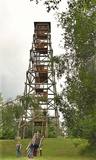
The tower on the eastern shore of Lake Engure (next to the meadow for wild cattle, accessible from the side of Bērzciems) offers a view of the reeds, small islands, Great Island, cows and horses of the north-eastern part of the lake. The tower on the northern shore of the lake (accessible from the side of Mērsrags) offers a look at the boating facility and the very overgrown northern part of the lake. The tower at the north-western shore of the lake (accessible from the side of Ķūļciems) shows the Apaļrova island (a footpath), stands of juniper, the boating facility, and the mosaic-like landscape of the lake itself.
|
|
 |
Natürliche Auenwiesen entlang der Ufer der Lielupe vor Jelgava. Viele geschützte Pflanzen findet man hier, Vögel nisten und rasten hier während des Vogelzugs.
|
|
|
|
Atrodas Cenas tīreļa dabas takas sākumā. No tā labi pārskatāma kūdrā izstrādātā Cenas tīreļa neliela daļa. |
|
 |
Lielais Liepu kalns ir Latgales augstienes Rāznavas pauguraines augstākā un Latvijā trešā augstākā virsotne (289,3 m v.j.l.). Lielpaugura relatīvais augstums ir 86 m! Skatu torņa platforma ir šobrīd augstākais Latvijas punkts (323 m.v.j.l.), kas sasniedzams ar paša kājām! Liepu kalna apkārtne ir labiekārtota. |
|
 |
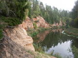
This is the ancient shore of the Baltic Ice Lake. We can only imagine the landscape 10,000 years ago, when the Kurzeme peninsula was covered with vegetation reminiscent of a tundra, and waves from the icy lake dashed against the ancient shoreline. We know that the lake was full of icebergs of various sizes. Today the cliff is more than 20 km long (some 9 km of it are in the Slītere National Park), and it is as much as 42 m high. It is the most impressive cliff of its type in all of Latvia. At the foot of the cliff are the Irve flatlands (the name comes from the Liv 'īrva' or 'īra', both of which refer to deer). The flatlands are the former bottom of the Baltic Ice Lake. The Blue Hills are crossed by many small streams and rivers (Pitragupe, Lorumupe, Kaļķupe, Mazupe, etc.). Their valleys are the basis for a branched and very complicated system of waterways which look particularly impressive when the trees are bare. In many places the cliffs and valleys display small areas of sandstone from the Narva suite. These are Latvia's oldest sediment cliffs that can be seen above ground. Although the Blue Hills are very impressive in scope, there are only a few places where there are important viewing areas (a viewing tower at the Dundaga-Mazirbe road, the view from the Šlītere lighthouse, the view from Mežlīdumi). The mightiness of the ancient shoreline can truly be enjoyed from the Cirste-Mazirbe road, the Cirste-Riepaldi road, Mežlīdumi and the Vīdala-Melnsils road). It is worth visiting the area in the springtime, when the slopes of the Blue Hills seem to be sinking under the fresh greenery. |
|
 |
Dole ist die größte Insel des Flusses Daugava. Von der nordöstlichen Seite wird die Insel vom Fluss Daugava umgeströmt, von der südwestlichen Seite – vom ruhigen und allmählich bewachsenen Gewässer des Seitengerinnes von Daugava. Die Insel ist ein Naturpark (das besonders geschützte Naturterritorium). Der Naturpark wurde 1987 zum Schutz der nach dem Bau des Rigaer Wasserkraftwerkes erhaltenen Landschaft und kulturhistorischen Werte der Insel von Dole, sowie seltenen und geschützten Pflanzen- und Tierarten gegründet. Noch ein Ziel des Errichtens des Naturparks ist die Förderung der Bildung und Erholung der Gesellschaft. Eins der bekanntesten Objekte der Insel von Dole ist das Daugava- Museum, das im Wohngebäude des Landgutes von Dole eingerichtet wurde. Im Fundus des Museums sind ~ 13 000 verschiedene Objekte – Zeugen der Geschichte der Insel von Dole und der Daugava-Ufer – Kleidung der Balten und Liven, Arbeitsgeräte, Alltagsgegenstände. Die Exposition macht mit der Geschichte des Flusses Daugava als mit dem bedeutenden Wasserweg und mit der Geschichte der Flößer und Transportmittel dieses Weges bekannt. Im Park des Landgutes von Dole ist eine Exposition des Museum unter freiem Himmel mit der Rekonstruktion der Neuenaugen-Fischzäune, einer Abdämmung für den Lachsfang und einer Sammlung der Fischereiwerkzeugen errichtet. Neben dm Museum befindet sich am steilen Ufer des Seitengerinnes von Daugava einen Dolomitaufschluss. Im südöstlichen Teil der Insel sind am Daugava-Ufer neben dem Haus “Bēči” die Ruinen der Burg von Vecdole zu finden. |
|
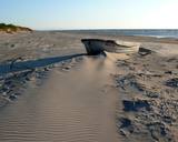 |
"Valgums" is a word referring to the sandy coastline zone between dunes and water, and once there were boats and nets that were being dried at this location. Each village had several areas of this type, and in the 1920s and 1930s, these were of great importance in the preservation of the Liv language. |
|
 |
The Neļķes cliffs are in Skaņākalns Park, and they offer the most beautiful view of the Salaka River valley, with its sandstone cliffs and peaceful river. There are good views from the “devil’s pulpit.” It’s worth visiting the Skaņamkalns Hill to check out the views from the famous echo cliff. This is part of the ZBR.
|
|
 |
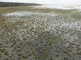
Dabas liegums veidots ezera, tā salu, ainavas, augu, putnu un sikspārņu aizsardzībai. Liegumu var apskatīt "no malas" - no ceļa, kas iet gar tā ziemeļu un ziemeļaustrumu robežu.
|
|
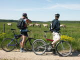 |
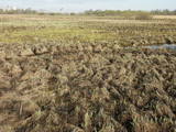
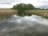
These meadows are of distinction because of the curvy Slampe River, which has caused a gradual recovery of damp meadows, complete with species of plants and animals that are typical of such areas. Domestic animals adapted for life in the wild can be seen here, and a bird watching tower on the location will offer you an excellent opportunity to view them. You can get to the meadows via a narrow corridor known as the Melnragu throat. The gravel road will lead to a hillock called Kurgāns from which you can have an excellent view of the surrounding landscape. |
|
 |
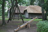
Kalētu muižas bijušais medību dārzs. Muižas laikos šeit ierobežotās platībās turēja meža dzīvniekus, kuru medības bija populārs muižniecības izklaides veids. Parkā uzmeklējams piemiņas akmens Krievijas imperatoram Aleksandram III, kurš šeit nošāvis briedi (irsi). No Kalētiem Latvijas teritorijā „ienāca” staltbrieži, kurus medību vajadzībām 1848. g. atveda no Vācijas. Parkā izveidotas takas un atpūtas vietas. |
|
 |
Ap 7 km garā apļveida taka sākas pie leģendārajām Mangaļu mājām. Tā iepazīstina ar latviešu strēlnieku kauju vietām, vietām, kur atradušās to fortifikācijas, t.s. „Vācu valni” u.c. liecībām. Mangaļu mājās – Ziemassvētku kaujām veltīts muzejs. |
|
 |
Der Park des Landgutes von Zasa befindet sich an den Ufern des Mühlenteiches von Zasa (im Norden von Zasa), der sich von dem Flus Zasa gebildet hat. Mit der Bildung des Parks wurde im 18. Jh. begonnen, der Park wurde als ein Landschaftspark im romantischen Stil gebildet. Gleichzeitig mit der Bildung des Parks wurde auch mit dem Bau des Schlosses von Zasa begonnen, deren Besitzer Heinrich von Sass war, nach dem der Bezirk von Riga Zasulauks benannt worden ist. Im 19. Jh., als das Landgut von Zasa einen anderen Besitzer bekommt, wird es als eines der reichsten und schönsten Landgüter der Umgebung angesehen. Es ist wert, einen Spaziergang in dem großen Park mit den vielen Brücken, dem Baum der Werwölfe, dem Teufelsstein und der heiligen Quelle zu machen. Die Besichtigung des Parks unter der Leitung eines Reiseführers: +371 26337227. |
|
 |
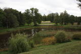
To the North of the Cesvaine Castle is a park that is crossed by the rapidly flowing Sūla River. The Cesvaine castle hill is on the northern bank of the river, is around 15 m high and is covered by trees today. The grave of the owner of the castle, Adolf von Wolff, is there. It is said that he wanted to have his casket dragged to the gravesite on a sled. He died during the summer, but that was done anyway. The park features a wide diversity of trees and bushes, some of which the owner brought home from his extensive travels. |
|
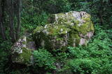 |
Līdz akmenim aizved (ir norādes) skaista taka, kas līkumo pa Rogāļu strauta izrauto gravu. Strauta kreisā krasta nogāzē, ~ 0,1 km pirms tā ietekas Daugavā, iegūlis 6,5 m garais, 4,6 m platais un līdz 3,7 m augstais Rogāļu akmens, kura tilpums ir novērtēts ap 40 m³. Blakus tam atrodas liela atlūza. |
|
 |
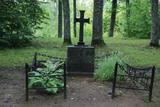
Auf dem Stein stand früher (heutzutage nicht
mehr zu sehen) eine Aufschrift, die besagte, dass die Liven vom schwedischen König
Karl IX und der Pest besiegt wurden. Vor Kurzem wurde noch ein Stein (der kleinere)
draufgestellt, der eine Zeit bei dem Haus Pakalni stand und dessen Aufschrift auch
verblichen ist. Die Steine befinden sich auf einer Grabstelle der Opfer der Pest.
|
|
 |
Viens no lielākajiem cilvēka veidotajiem Latvijasparkiem (70 ha), kas izstiepies no Liepājas ostas līdz Dienvidu fortam > 3 km garumā. Tā izveidi uzsāka jau 1870. g. pēc pilsētas mēra K. Ūliha iniciatīvas, uzbūvējot kūrmāju un strūklaku. 19. - 20. gs. mijā ap Dzintaru un Liepu ielām parādījās greznu villu un savrupmāju apbūve. Viena no skaistākajām ir jūgendstilā celtā savrupmāja Liepu ielā 27, kurā atrodas Krievijas ģenerālkonsultāts. Ēkai ir slēgta uzeja, balkoni, pildrežģa konstrukcijas un kārniņu jumts (arhitekti G. Jenike un P. M. Berči). Jūrmalas parks visās sezonās ir iecienīta pastaigu un dažādu aktivitāšu norises vieta. Te meklējams stadions „Daugava”, tenisa korti, koncertestrāde “Pūt, vējiņi!”, vasaras kafejnīcas, minigolfa laukums, bērnu rotaļu laukums, skeitparks. Šeit meklējamas lielākās Latvijas bungas – vides dizaina objekts. |
|
 |
Dundagas pili ieskauj parks, kura pirmsākumi ir meklējami jau 17. gs. Tam cauri tek Pāces upīte, kuras uzdambējums veido Dundagas dīķi. Tajā atrodas senatnē (vēl pirms pils būvniecības) mākslīgi veidota sala - Kalnadārza pilskalns. Tam iepretim (dīķa austrumu krastā) atrodas Dundagas pilskalns. Parkā joprojām zaļo (daži lielākie zari ir nolūzuši) t.s. “Rubļa ozols”, kura attēls bija uz 1919. g. izdotās Latvijas simts rubļu naudaszīmes. Parkā uzcelta estrāde. |
|
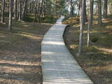 |
Plieņciema taka atrodas dabas liegumā "Plieņciema kāpa" starp Plieņciemu un Ķesterciemu. Pāri kāpai ir izveidota laipu taka un atpūtas vieta. Taka ir izveidota, lai mazinātu negatīvo ietekme uz Plieņciema kāpas dabas vērtībām – zemsedzes nomīdīšanu, piegružošanu ar atkritumiem, braukšanu ar autotransportu.
|
|
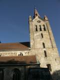 |
The tower of St John’s Lutheran Church in Cēsis, which is one of the oldest stone buildings in Vidzeme, offers a view of the historical centre of Cēsis, and a wide area all the way to Zilaiskalns Hill. There is also the western tower of the ruins of the Cēsis castle, one of the strongest fortresses of the Livonian Order in the Baltic region, and it offers a grand view of the castle’s park.
|
|


