
| No | Name | Description |
|---|---|---|
 |
Skuķu un netāli esošais Dvietes ezeri ir vieni no teritorijas grūti pieejamajiem palieņu ezeriem – lielākie šāda tipa
ezeri Latvijā. Palu laikā pārplūst, savienojoties vienā lielā ūdenskrātuvē.
|
|
|
|
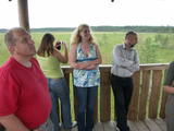
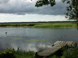
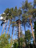
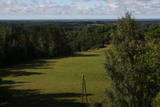
Atrodas Skuķu ezera ziemeļaustrumu krastā. No torņa labi saskatāms aizaugušais Skuķu ezers ar nelielām ūdens lāmām un ūdeņiem bagātos pavasaros pārplūstošā Dvietes paliene. Laba putnu vērošanas vieta. |
|
 |
The tower is beyond the Oleri estate, in the small Oleri swamp, where at the end of a wooden footpath you can step upward a bit and learn about the landscape of a transitional swamp. This is part of the ZBR.
|
|
 |
This is a segment of the Gauja River which is full of rapids in some places. It stretches from Vidaga and the place where the Vecpalsa River flows into the Gauja. Along the Gauja and its tributaries, dolomite outcrops can be seen on the shores, and the largest of these are the Randati cliffs. The restricted area was established mostly to protect various kinds of forests, meadows, outcrops and their habitats. This is an interesting part of the central section of the Gauja for people who enjoy beautiful landscapes and for those who are water tourists.
|
|
 |
Ilziņš jeb Vestienas dzirnavezers pazīstams ar nostāstiem par tajā "periodiski uzpeldošām kūdras salām". Saskaņā ar vietējo iedzīvotāju sniegtajām ziņām, minētā parādība gan sen jau vairs nav novērota. Tajā pat laikā ezers un tā apkārtne ir nozīmīga daudzu aizsargājamu biotopu un sugu dzīves vieta. Ezers ietilpst Vestienas aizsargājamo ainavu apvidū. Ezeru var redzēt, braucot pa Ērgļu - Gaiziņkalna ceļu. Var pakāpties arī blakus esošajā paugurā (ziemeļos no minētā ceļa un ezera), no kura paveras plašāka skatu perspektīva.
|
|
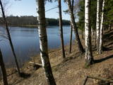 |
Lake Valgums is 3 km long and 27 m
deep, and it dates back to the last Ice Age.
|
|
 |
This is a large set of coastal meadows, ancient rivers and areas of reeds. It is found at a location where the Daugava River used to flow – between Vecmīlgrāvis and Vecāķi. There are inland dune meadows here, complete with the very rare silver grass. Vecdaugava is an important location for nesting birds and several uncommon plant species. On the southern end of the Vecdaugava peninsula, at a place called Skanstnieki, one can find remnants of medieval Swedish fortifications. The Vecdaugava Regional Research and Fishing Museum is here, as well.
|
|
 |
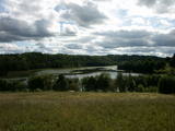
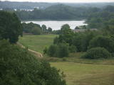
This area protects the landscape of the Lielauce hillocks, which are a part of the Eastern Kurzeme highlands. Lake Zebrus and Lake Svēte are in this territory. On the north-eastern shore of Lake Zebrus one can see the Ezerlūķi castle hill. On the eastern shore of the lake is a boating area, along with a viewing tower and a set of information about the area. The territory includes protected biotopes such as stream swamps and swampy forests, along with protected birds and species of bat. |
|
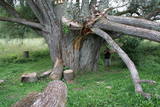 |
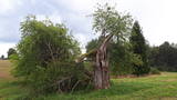
This is certainly the thickest White Willow (Salix alba) in Latvia and perhaps the thickest one in the Baltic States. Many of its mighty branches are resting on the ground, and the enormous monolithic trunk has been split. There’s a small information stand alongside the tree. A pathway which starts at the Raganu cliffs can be taken to the tree.
|
|
 |
Latvia’s newest national park (2007) is in the “land of the blue lakes” – the region of Latgale. One of the goals of establishing a national park was to preserve the natural treasures of the region. Lake Rāzna, which is the second largest in Latvia, is there, as is Lake Ežezers, which has more island than any other lake in Latvia. There are other bodies of water, as well as typical landscapes of hillocks and a unique cultural environment. One of the most popular destinations in the park is Mākoņkalns Hill, which offers a lovely view of Lake Rāzna. Administrators of the newly established park are working on the tourist infrastructure – trails, routes, etc. Perhaps visitors would be advised to postpone their trip to the Rāzna National Park for awhile. |
|
|
|
Atrodas Liepājā, E. Tisē un Lauku ielas krustojuma galā. Pa Ezera laipu (Liepājas ezera palieņu pļavas) var nokļūt līdz putnu vērošanas tornim, no kura labi pārlūkojama ezera ziemeļdaļa. Laba putnu vērošanas vieta. Ietilpst Liepājas ezera dabas lieguma teritorijā. |
|
 |
Uzcelts apkaimes augstākajā vietā – Ančupānu meža kalnā, kuru vietējie dēvē par „Bāku”. No 26 m augstā torņa redzama ļoti plaša panorāma ar Rēzeknes pilsētas namiem, baznīcu torņiem un apkaimes mežu masīviem, kas mijas ar lauksaimniecībā izmantojamām zemēm. Blakus tornim – atpūtas vieta. |
|
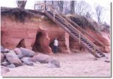 |
Ainavisks jūras viļņu izskalots smilšakmens atsegums
dienvidos no Zaķupes ietekas.
|
|
 |
Kokneses dabas taka (5,65 km) ved gar Daugavas un Pērses krastiem un savieno Kokneses parku un Likteņdārzu. Pastaigā pa dabas taku var doties no jebkuras sevis izvēlētas vietas, kas vijas cauri Kokneses parkam. Takā izveidotas laipas, tiltiņi, informācijas stendi un norādes. |
|
 |
This is the thickest European wild apple tree in Latvia. It is just lovely when it is blossoming.
|
|
|
|
The cave, which is 45 m deep and up to 5.5 m wide is found on the right bank of the Strīķupe river, by the Cēsis-Lenči road. The cave and its nearby sandstone cliff have suffered much damage from local visitors, which is why the administrators of the national park limited access to the surrounding territory a few years ago. You can no longer approach the cave. This is a positive example of who an important geological monument and a protected biotope can be protected. |
|
 |
This is the highest church tower in Latvia, and from it you can see views of the Alūksne highlands. The view to the South is particularly impressive.
|
|
|
|
Atrodas Cenas tīreļa dabas takas sākumā. No tā labi pārskatāma kūdrā izstrādātā Cenas tīreļa neliela daļa. |
|
 |
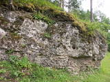
These sandstone cliffs were once known as the Pieškalni or Pieškaļi cliffs. They are around 7 km to the North from the centre of Cēsis. These are the most monolithic sandstone cliffs in the Baltic States – around 700 m long (with some 330 m along the Gauja River) and a maximum height of 22 m. There is a viewing area which offers a grand view of the Gauja River valley. Water tourists will boat up to the majestic wall of the cliff and will be surprised at what they see! The name of the cliffs, Ērģeles, is the word for "pipe organ" in Latvian, and the name was supposedly given to the cliffs because of the echoes which can be heard there – they reputedly sound like an organ. Hikers and boaters must be very careful when in this area – please make sure that you are safe! Please note, too, that the infrastructure of the cliff is scheduled to be renovated in 2012. |
|
 |
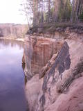
This is the ancient shore of the Baltic Ice Lake. We can only imagine the landscape 10,000 years ago, when the Kurzeme peninsula was covered with vegetation reminiscent of a tundra, and waves from the icy lake dashed against the ancient shoreline. We know that the lake was full of icebergs of various sizes. Today the cliff is more than 20 km long (some 9 km of it are in the Slītere National Park), and it is as much as 42 m high. It is the most impressive cliff of its type in all of Latvia. At the foot of the cliff are the Irve flatlands (the name comes from the Liv 'īrva' or 'īra', both of which refer to deer). The flatlands are the former bottom of the Baltic Ice Lake. The Blue Hills are crossed by many small streams and rivers (Pitragupe, Lorumupe, Kaļķupe, Mazupe, etc.). Their valleys are the basis for a branched and very complicated system of waterways which look particularly impressive when the trees are bare. In many places the cliffs and valleys display small areas of sandstone from the Narva suite. These are Latvia's oldest sediment cliffs that can be seen above ground. Although the Blue Hills are very impressive in scope, there are only a few places where there are important viewing areas (a viewing tower at the Dundaga-Mazirbe road, the view from the Šlītere lighthouse, the view from Mežlīdumi). The mightiness of the ancient shoreline can truly be enjoyed from the Cirste-Mazirbe road, the Cirste-Riepaldi road, Mežlīdumi and the Vīdala-Melnsils road). It is worth visiting the area in the springtime, when the slopes of the Blue Hills seem to be sinking under the fresh greenery. |
|


