
| Нo | Название | Описание |
|---|---|---|
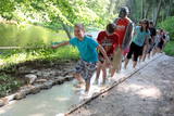 |
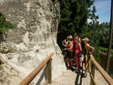
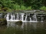
The first barefoot trail created in the Baltic States in the recreation complex "Valguma pasaule", which is located on the forested shores of Lake Valguma. When walking on the path, the feet "massage" sand, wood chips, clay, peat, gravel, cones and various other materials. |
|
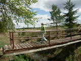 |
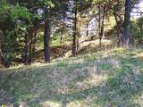
A small and forested territory with sulphurous springs, among which the most popular one is the Ellīte sulphur spring. It has sulphurous water with a low level of minerals, and the water supposedly has medicinal properties. The area around the stream is well-appointed, and a pathway leads to it. The stream is considered to be the source of the Iecava River. The restricted area is there to protect biotopes and protected plants which are in the area.
|
|
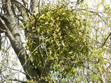 |
This is a mostly forested territory which is home to one of the largest areas of the white mistletoe, which is a semi-parasitic plant. It is best to observe this unique plant when it has no leaves. Latvia is the northern limit to the white mistletoe, which is why it is not all that common. It is interesting that even more of this rare specie can be seen outside of the nature restricted area. |
|
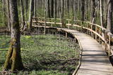 |
Uz pāļiem veidotā koku laipu taka līkumo cauri Vēršupītes dumbrājiem (pārmitri platlapju meži), tādēļ visiespaidīgākie skati šeit ir vērojami tieši pavasara palos vai citos gadalaikos pēc lielām lietavām, kad mazā upīte iziet no krastiem un appludina dumbrājus lielākā platībā. Par teritorijas sezonālu applūšanu liecina arī daudzo alkšņu resnie sakņu kakli, kas nevilšus atgādina mangrovju audzes. Mitrie meži ir viens no sugu skaita ziņā daudzveidīgākajiem Latvijas biotopiem.
|
|
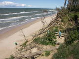 |
Начинается в нескольких километрах к северу от Павилосты и заканчивается недалеко до Ошвалки, протяженностью > 30 км. Его внушительные и необыкновенные формы просматриваются на участке Странте - Улмале, но и открывающиеся в окрестностях Юркалне (благоустроенные места для подхода, лестницы, автостоянки) виды (высота до 16 м) оставляют незабываемое впечатление! Отвесный берег рекомендуется наблюдать (смотреть, фотографировать) после сильных бурь, потому что во второй половине лета его обнажения (главным образом, песчаник, глина) выглядят менее выразительными из-за оползней и покрывающей растительности. Предыдущее название Юркалне – Феликсберг означало Счастливая гора. Теперешнее название это место получило в 1925 году. |
|
 |
Dabas takā gar Rojas upi iespējamas 3 dažāda garuma distances, kas lokveidā ved gar upi un tai pieguļošajiem mežiem – 2 km, 7 km un 15 km, kas katra atzīmēta ar savas krāsas norādēm. Dzeltenais aplis 2 km, zilais aplis – 7 km, sarkanais aplis – 15 km. Maršrutus var veikt arī ar velosipēdu, taču braucot ar velo, atsevišķi posmi var būt grūti izbraucami smilšu dēļ. Pie upes ierīkotas vairākas atpūtas vietas ar soliem, galdiem, labierīcībām, šūpolēm, vingrošanas konstrukcijām, atkritumu urnām, kā arī ugunskura un telšu vietām. Pie atpūtas vietām Žocenē un Rojā ir izveidotas arī laivu piestātnes. Takas sākumā upes krastā labiekārtota vieta, kur upē ietek Rojas avots, ko kā ūdensņemšanas vietu iecienījuši vietējie iedzīvotāji. |
|
 |
Einen malerische Sandsteinfelsen bis 600 m lang und 21 m hoch am linken Flussufer vom Gauja. |
|
 |
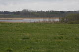
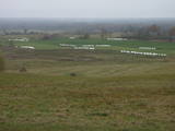
Open landscape area within farming lands on both banks of Uzava River about 10 km before it flows into the Baltic Sea. There is a good open view over the area from the Vendzava-Ziri road going through the nature park. Protection of migratory birds and corncrakes has been one of the main reasons for establishment of the nature park. Bird watching is possible from the road Vendzava-Ziri during migration period in spring and fall. There is no tourist infrastructure in the nature park.
|
|
 |
This restricted area was established to protect a high-type swamp, a swampy forest and a series of rare birds. The Niedrāji-Pilka swamp can be crossed with dry feet while enjoying almost virginal nature. This is possible on the narrow-gauge railroad embankment which runs through the swamp for three to four kilometres from the North-east to the South-west, or on the well-appointed circular wood pathway which is on the eastern size of the embankment.
|
|
|
|
Near the Priedīši homestead, there is a nature trail which allows visitors to study Lake Dziļezers and the surroundings. There are various lakes in this region which are found in a depression left behind by the Ice Age – Lake Dziļezers, Lake Riebezers, Lake Mazezers, Lake Auziņš, Lake Skuja and Lake Bruņķītis are all there. Along their shores, there are various kinds of forests, including ones with broadleaf trees that are under environmental protection. The trail is 3km in length and will take an hour or so to traverse. This is a part of the environmentally restricted territory of Lake Dziļezers and Lake Riebezers.
|
|
 |
In terms of shape, this is one of the most diverse areas of uncovered sandstone in Latvia. Found on the right bank of the Gauja river, the Sietiņiezis is up to 15m high. Small holes that can be seen in the cliff face are created by single and protected insects, which carve tiny caves in the cliff for their caterpillars. A circular and well appointed trail, with stairs, has been installed. It is 1.5 km in length and will take an hour or so to traverse. Objects are in the Gauja National Park.
|
|
 |
The Vilce Nature Park is small in size and exists alongside the deep valleys of the Vilce River and its tributaries. Biotopes include visible sandstone cliffs, rapids on the rivers, forests typical of such areas, and the plants and animals that are found therein. The well-appointed Vilce castle hill is next to the Zaķu meadow, which is a nicely appointed and popular place for recreation. |
|
 |
Nature restricted area surrounds Tasu Lake and swampy shores of it in a narrow band. The territory was established to protect rare nesting and migratory birds. The territory is easily overseen from the narrow gravel roads all around the area not entering the actual protected area. Tasu Manor house is located to the South of nature restricted area.
|
|
 |
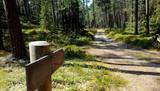
Folkloras taka "Jāņkalni" iepazīstina ar mūsu senču rakstiem, zīmēm un dievībām, kas ir mūsu folkloras mantojums. Folkloras takas (garums: apm. 1,5 km vai 2 stundas) mērķis ir arī iepazīstināšana ar senlatviešu ieražām, folkloru, kā arī tautu dainu izprašana. Piedāvā iziet Latvijas karti - labirintu ar 19 etnogrāfiskajiem novadiem. Gids Jums sniegs izsmeļošu stāstījumu un atbildes uz interesējošiem jautājumiem.
|
|
|
|
Atrodas Sedas purvā (Sedas dabas takas malā) ar plašu skatu uz izstrādātajām kūdras platībām. Sedas taku ieteicams izstaigāt vietējā gida pavadībā T: + 371 2636162. |
|
 |
Гора Мицану-Киркас. Маленький замок в Приежукалне в
1792 году был преобразован в лютеранскую церковь. До сих пор
гору называют „Кирха” (нем. Kirche – церковь). Пожилые люди
говорят, что под церковью был построен большой подвал, в котором хранились драгоценности семьи
Мантейфелей и церкви, в подвале находится семейный склеп Мантейфелей.
|
|
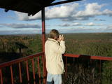 |
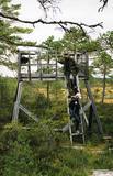
The viewing tower is in the southern part of the reserve, along the Ļaudona-Mārciena road and on the Madona-Trepe embankment. Here you can view a very wide territory all the way to the Vidzeme highlands, including Gaiziņkalns Hill if the weather is clear. At the foot of the tower you will see the lakes known as Small and Great Lake Plencis. |
|
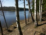 |
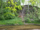
Озеро Валгума – протяженностью до 3
км в длину и глубиной 27 м озеро
образовалось в субгляциальной рытвине
(ледниковое).
|
|
 |
Elka Hill is one of the highest surfaces in the western part of the Vidzeme highlands, and it offers a lovely and broad view to the North. There is a small parking lot, a TV and radio tower, and the place where the Gauja River is thought to originate.
|
|
 |
The ancient Abava River Valley between Kandava and the place where the river flows into the Venta River is the most expressive river valley segment in Kurzeme in terms of landscape and terrain. The valley is 30 to 40 metres deep and as much as 300 metres wide. The territory is distinguished by great diversity of a biological nature (more than 800 kinds of plants), featuring many different biotopes and natural monuments such as streams, waterfalls, cliffs, huge rocks, and many cultural and historical monumentssmall towns such as Kandava and Sabile. In both cases, the town centres are national monuments of urban construction. Popular tourist destinations include Vīnakalns hill in Sabile, where wine-making grapes are grown, as well as the open-air art museum at Pedvāle. To protect cultural treasures, a cultural and historical territory, “Abava River Valley” has been established. Wild livestock live at Drubazas and Tēvkalni to “maintain” the landscape. There are nature trails for tourists, and the Abava is the most popular river for water tourists in Kurzeme. Information is available at the tourist information centres in Kandava and Sabile. such as castle hills, churches, ancient burial grounds, and
|
|


