
| Nr | Name | Beschreibung |
|---|---|---|
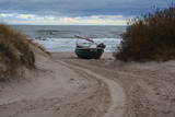 |
Ceļa, kas ved uz jūru – galā, redzami Latvijas piekrastei samērā reti skati. Ja palaimējas, šeit var novērot vietējos zvejniekus darbībā, kas joprojām iet zvejā. Krasta kāpās aplūkojamas vecas, pamestas un arī sagrieztas zvejas liellaivas un dažādi mūsdienu zvejniecībā izmantojami „darba rīki”. |
|
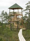 |
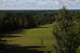
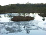
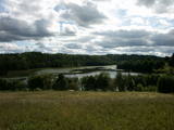
This is part of a hiking trail along the Cena bog. It is on the western side of the bog, at the centre of the 5-kilometre circular trail. You can see the vast swamp, as well as a military road that was installed during World War I and is marked by an “alley” of large pine trees. Alongside the tower is a fragment of the road that was installed more recently.
|
|
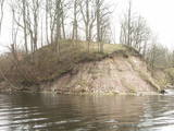 |
Where the little Rumbiņa river flows into the Daugava (on the left bank of the little river opposite the Lielvārde park), there is the Dievkalns castle hill that has been reduced by the waters of the Daugava. It is also known as the Cepure hill. According to antiquities that have been found here, representatives of Baltic tribes lived here from the first millennium BC to the 6th or 7th century AD. The level of the Ķegums hydroelectric power plant can be reached by a staircase from which the best view of this object can be found.
|
|
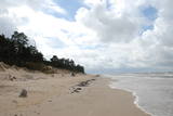 |
Бернати - самая западная точка суши Латвии. Рядом с автостоянкой установлен каменный знак скульптора Вилниса Титанса «Зеленый луч» (1998 г.). Бернатский мыс подвержен воздействию ветра и волн, поэтому здесь наблюдается вымывание морского берега. У дороги, которая из центра поселка Бернати ведет к морю, в конце дюн (имеется указатель), установлен памятный камень со словами первого Президента Латвии Яниса Чаксте, сказанными в 1924 году: «Здесь должен быть курорт». |
|
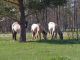 |
Für den Zweck der Bewirtschaftung der Niederungsauen des Pape-Sees und der Vermehrung der biologischen Vielfalt sind hier Konik-Wildpferde angesiedelt wurden. Die kann man mit einem örtlichen Guide kennenlernen. |
|
 |
This is a lovely place in Sigulda which has been painted (as the word "gleznotāji", which means "painters" suggests) and photographed for centuries. This is basically not a hill at all, it's just the place where the shore of the ancient Gauja River valley is split by the mighty Vējupīte ravine. You will have an excellent view of the Turaida Castle and the river valley. There are leisure facilities and a viewing platform there. You can ride to Paradīze hill via an electric car. |
|
 |
This is the highest church tower in Latvia, and from it you can see views of the Alūksne highlands. The view to the South is particularly impressive.
|
|
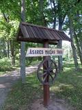 |
Asares muižas romantiskā stila dendroloģiskais ainavu parks veidots 18. gs. un papildināts 19. gs. 2. pusē. Muižas parka teritoriju ieskauj laukakmeņu mūris. Bet parkā sastopamas daudz interesantas krūmu un koku sugas: Sibīrijas baltegles, Eiropas lapegles, duglāzijas, šķeltlapainie baltalkšņi, Švedlera kļavas, košumkrūmi, dažādi lakstaugi. Liepu alejā - 2 dižkoki. Tempļa kalna atjaunotajā lapenē - muižnieku tējas dzeršanas vieta ar skatu uz pili. |
|
|
|
Atrodas Liepājā, E. Tisē un Lauku ielas krustojuma galā. Pa Ezera laipu (Liepājas ezera palieņu pļavas) var nokļūt līdz putnu vērošanas tornim, no kura labi pārlūkojama ezera ziemeļdaļa. Laba putnu vērošanas vieta. Ietilpst Liepājas ezera dabas lieguma teritorijā. |
|
 |
Das Bažu Moor – ist das größte Moor im Nationalpark Slītere. Es befindet sich
in der strengen Zone vom Naturverbot und ist für Besucher gesperrt.
|
|
 |
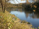
Das ist ein Abschnitt des Gauja – Flusses mit Stromschnellen an einigen Stellen. Es erstreckt sich von Vidaga bis zum Ort, wo der Fluss Vecpalsa indie Gauja fließt. Entlang der Gauja und seinen Nebenflüssen kann man Dolomitaufschlüsse an seinen Ufern sehen, die größten sind die Randati – Klippen. Das Territorium wurde vor allem eingerichtet, um die verschiedenen Arten an Wald, Wiesen, Aufschlüssen und ihre Habitate zu schützen. Das ist ein interessanter Abschnitt des zentralen Teils der Gauja, vor allem für Leute, die die schöne Landschaft genießen möchten und für Wassertouristen.
|
|
 |
Das Naturreservat ist eine der größten Moorflächen des Baltikums. Es wurde in das Verzeichnis bedeutender Feuchtgebiete gemäß der Ramsar Konvention aufgenommen. Im Moor von Teiči wurde der etwa 3 km langer Lehrpfad Sildi angelegt, der nur in Begleitung von Reservatsführern nach Anmeldung besucht werden darf. Es können verschiedene Moortypen (über Stege), Moorseen (Sildi und Isliena), Wasserlöcher und Kleingewässer und moortypische Arten sowie die Moorinsel besichtigt werden. Vom Aussichtsturm in Siksala kann man den größten Teil des Moores überblicken. The trail can be visited only with the Nature Conservation Agency employee's escort from June 1 until October 31. |
|
 |
Ein geschütztes Territorium mit einer Reihe von künstlichen Teichen im Südwesten von Saldus. Die Teiche ziehen viele verschiedene Vogelarten während der Nist- und Vogelzugzeit an. Der Ort wurde nicht für touristische Zwecke aufbereitet, trotzdem ist es ein interessanter Ort zur Vogelbeobachtung. In den Wäldern um die Teiche sind auch viele geschützte Vögel und Fledermausarten beheimatet.
|
|
|
|
Das Gebiet wurde eingerichtet, um diesen Teil des Ogre – Flusstales zu schützen, das ein Flussbett aus der Eiszeit hat und Wiesen mit entsprechenden Biotopen und Populationen. Unter anderem die Bergulme und die Flatter - Ulme, die nicht oft in Lettland zu finden ist.
|
|
 |
Teritorija, kas aptuveni 20 km garumā „piekļāvusies” abiem Aiviekstes upes krastiem. Dabas parka galvenā vērtība ir palieņu pļavas (un citi pļavu biotopi), kas ir ļoti nozīmīga daudzu augu un dzīvnieku (īpaši – putnu) sugu dzīves vieta. Ūdenstūristiem, kas laivo pa Aivieksti, nakšņošana ir jāplāno tikai šim mērķim paredzētās vietās!
|
|
 |
Gar Grobiņas ūdenskrātuvi (Ālandes labais krasts) izveidota mūsdienīga un labiekārtota pastaigu un atpūtas vieta - promenāde, uz kuras izvietotas plāksnes ar Zentas Mauriņas un Jāņa Raiņa citātiem. No promenādes paveras labi skatu punkti uz Skābaržkalnu un Grobiņas pilsdrupām. Grobiņas ūdenskrātuves sašaurinājumā pāri Ālandei ved neliels tiltiņš, kas ir bijušā Liepājas – Aizputes šaursliežu dzelzceļa tilta ferma. |
|
 |
Krāču Hügel – eine Reihe von welligen Hügeln,
die sich während der Zeit vom Litorinischen Meer bei
starkem Wind gebildet haben. Von den Krāču Hügeln
ergibt sich ein wundervoller Blick auf den Liliensee.
Gegenüber vom See, am östlichen Teil der
genannten Straße, kommt man über Dolomitstufen
bis zum Denkmal für 90 lettische Schützen die 1 91 7
in Kämpfen gefallen sind.
|
|
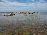 |
Vitrupe – Tūja ist ein wichtiges Naturschutzgebiet für Riffe. Das Gebiet befindet sich gegenüber der Region Salacgrīva. Die Fläche beträgt 3577 ha. Das Gebiet enthält den Meeresteil vom Naturverbot „Die Steinküste von Vidzeme“
|
|
 |
Natürliche Auenwiesen entlang der Ufer der Lielupe vor Jelgava. Viele geschützte Pflanzen findet man hier, Vögel nisten und rasten hier während des Vogelzugs.
|
|
 |
Ilziņš jeb Vestienas dzirnavezers pazīstams ar nostāstiem par tajā "periodiski uzpeldošām kūdras salām". Saskaņā ar vietējo iedzīvotāju sniegtajām ziņām, minētā parādība gan sen jau vairs nav novērota. Tajā pat laikā ezers un tā apkārtne ir nozīmīga daudzu aizsargājamu biotopu un sugu dzīves vieta. Ezers ietilpst Vestienas aizsargājamo ainavu apvidū. Ezeru var redzēt, braucot pa Ērgļu - Gaiziņkalna ceļu. Var pakāpties arī blakus esošajā paugurā (ziemeļos no minētā ceļa un ezera), no kura paveras plašāka skatu perspektīva.
|
|


