
| Nr | Name | Beschreibung |
|---|---|---|
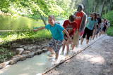 |
The first barefoot trail created in the Baltic States in the recreation complex "Valguma pasaule", which is located on the forested shores of Lake Valguma. When walking on the path, the feet "massage" sand, wood chips, clay, peat, gravel, cones and various other materials. |
|
|
|
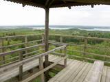
Uzcelts Kaņiera pilskalnā un ir Kaņiera pilskalna takas sastāvdaļa. No torņa paveras izcila Kaņiera ezera dienvidrietumu daļas ainava ar niedru saliņām un nelieliem atklāta ūdens laukumiem. Laba putnu vērošanas vieta. |
|
 |
1,8 km garā taka atrodas neparastā vietā – uz Cirīša ezera salas. Tās galvenās vērtības ir augu valsts un dzeņveidīgo putnu daudzveidība. Viens no apskates objektiem ir Upurkalns – sens pilskalns. Taka labiekārtota, izveidoti informācijas stendi, atpūtas vieta. Lai nokļūtu uz salas, no vietējiem jānomā laiva, vai jādodas ar savējo. Atrodas dabas parkā „Cirīša ezers”. |
|
|
|
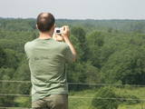
No ūdens tūrisma attīstības centra „Bāka” skatu laukuma, kas atrodas Lubāna ezera ziemeļdaļā pie V 560 autoceļa, paveras viens no labākajiem Lubānas ezera skatiem. Redzams milzīgais Latvijas lielākā ezera klajs un Kvāpānu – Īdeņas zivju dīķu ar dambjiem ainava. |
|
 |
Plieņciema taka atrodas dabas liegumā "Plieņciema kāpa" starp Plieņciemu un Ķesterciemu. Pāri kāpai ir izveidota laipu taka un atpūtas vieta. Taka ir izveidota, lai mazinātu negatīvo ietekme uz Plieņciema kāpas dabas vērtībām – zemsedzes nomīdīšanu, piegružošanu ar atkritumiem, braukšanu ar autotransportu.
|
|
|
|
Atrodas Sedas purvā (Sedas dabas takas malā) ar plašu skatu uz izstrādātajām kūdras platībām. Sedas taku ieteicams izstaigāt vietējā gida pavadībā T: + 371 2636162. |
|
 |
Der Svente - Naturpark liegt im mittleren Teil des Augšzeme-Hochlandes mit dem See Svente in seinem Zentrum. Das ist einer der saubersten Seen in Lettland. Der Egļukalns - Berg bietet von seinem Aussichtsturm einen der schönsten Blicke in ganz Zemgalen. Besucher können die Hügel und Seen des Svente - Gebietes bestaunen. Der Egļukalns - Berg hat sowohl Skipisten als auch einen Naturpfad.
|
|
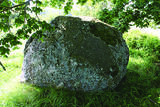 |
Der große Peststein – mit der eingemeißelten Aufschrift, die nur schwer zu lesen
ist, wollte man den nächsten Generationen über den damaligen örtlichen Pfarrer (der
während der Pest gestorben ist) und über die Bildung eines Pastorats in Sīkrags
mitteilen. Das Pastorat wurde aber kurz danach nach Mazirbe verlegt. Der Peststein ist
auch ein Denkmal für sechs Pfarrer der örtlichen Gemeinden. Alle drei Steine (Nr.7)
teilen über die große Pest von 1710 mit. Die Aufschriften auf den Steinen wurden von
Mazirbes Pfarrer Petersons von 1711 bis 1734 eingemeißelt.
|
|
|
|
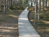
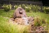
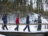
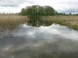
2006 wurde ein Pfad im Planču Moor angelegt. Vielleicht der einzige Naturpfad in Lettland, an dem auch ein Informationsstand in Blindenschrift vorgesehen ist.
|
|
 |
Lielbātas dabīgais dzidravots ir lielākais Latvijā un viens no retajiem Ziemeļeiropā, kas zemes virspusē no dzīlēm iznes bioloģiski aktīvu un pareizi strukturētu ūdeni. Lielbātas dzidravots tek no rietumiem uz austrumiem pretī saulei, tāpēc jau izsenis tiek uzskatīts par maģisku, pat svētu, kam piemīt dziednieciskas spējas. Vēstures materiālos Lielbātas avots pirmo reizi pieminēts 1253. gadā un līdz šim brīdim turpina savu plūdumu. Lielbātas avots atrodas sakoptā un ekoloģiski tīrā vidē. Laikam ritot, avota ūdens plūsma nav mazinājusies, bet tieši pretēji, tā ir pieņēmusies spēkā un ar apbrīnojamu jaudu avots turpina dot unikālu dabas velti – tīru, bioloģiski aktīvu, pareizi strukturētu ūdeni, neapstājoties ne dienu, ne nakti, ne ziemu, ne vasaru. Netālu no avota atrodas vēsturiskā Vaiņodes jeb Lielbātas pils, kuru 19. gs. vidū būvēja barons Osten Sakens. Vēstures liecības liecina, ka šī vieta pils būvniecībai nav izvēlēta nejauši. 1923. gadā pilī tika izveidota sanatorija, kas ne tikai bija priekšzīmīgākā Latvijā, bet varēja cienīgi līdzināties ārzemju sanatorijām. Tam par iemeslu bija dabiski tīrā un dziednieciskā vide, kas saglabājusies līdz pat mūsdienām. Lielbātas pils ir privātīpašums un apmeklētājiem nav pieejama, taču Lielbātas avots ir brīvi pieejams, un katram ir iespējams nogaršot avota ūdeni. Adrese: Vaiņodes pils, Vaiņodes pagasts, Dienvidkurzemes novads LV-3535 |
|
 |
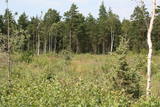
Die Wälder von Zvārde befinden sich auf einem ehemaligen sowjetischen Luftstützpunkt. Das Gebiet war nicht bewohnt und für Zivilisten nicht zugänglich. Auf dem riesigen Gelände gibt es verschiede Waldarten – Nadelwald, Schwarzerlensümpfe usw. Die Tatsache, daß das Militär dieses Gebiet kontrolliert hat, ist der Grund dafür, daß in den Wäldern von Zvārde viele seltene und geschützte Vögel leben, brüten und Futter finden. Einige Teile des alten Luftstützpunktes sind noch vorhanden, wie z.B. eine Überwachungsstation. Es wird empfohlen, daß sich Besucher nur auf den allgemein benutzten Straße bewegen.
|
|
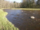 |
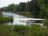
Der Naturpark im Tal des Ogre-Flusses befindet sich im mittleren Abschnitt des Flusses. Er wurde eingerichtet, um das unregulierte Flusstal und das ihn umgebende Territorium sowie die biologische Vielfalt mit dem Lebensraum zu schützen. Zum Beispiel das Gebiet, in dem seltene park-typische Wiesen vorhanden sind. Der Ogre-Fluss ist einer von Lettlands beliebtesten Flüssen für Wassertourismus im Frühling, besondern flussabwärts des Ortes Ērgļi, wo die technisch kompliziert zu befahrenden Braži – Stromschnellen sind.
|
|
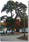 |
Die prächtige Kiefer in Bigauņciems
bei dem Café Dižpriede.
|
|
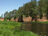 |
Dieser Park ist ein Gebiet, das vom Menschen kaum verändert wurde – Sandsteinklippen, verschiedene Höhlen, Biotope, Arten und Landschaften sind der attraktive Aspekt dieses Gebietes. Der Salaca-Fluss ist einer der wichtigsten Flüsse in der Ostseeregion als Laichgebiet für den Lachs, und es ist der zweitwichtigste Fluss für Wassertourismus in der lettischen Region von Vidzeme. Hier gibt es geologische Denkmäler, die für Besucher besonders attraktiv sind – Die Roten Klippen, der Skaņais-Berg, die Neļķu-Klippe, die Velna-(Teufels) Höhle usw. Hier sind auch solche Kulturdenkmäler wie der Livische Burgberg, der Vecsalaca - Gutshof, das Livische Museum, das Vantenberģi - Anwesen, die einzigartigen Neunaugen - Stauwehre usw. Im Park befindet sich auch eins der beliebtesten touristischen Ziele in Nordvidzeme – der Skaņākalna-Park, der ein dichtes Netz von Wanderpfaden hat. Der Salaca ist auch beliebt bei Fischern. Dies ist Teil des Nordvidzemer Biosphärenreservats.
|
|
 |
Similar as Alsungas mezi (Alsunga forests) – is not intended and appropriate for visits. A narrow path of the restricted area can be seen from the gravel road – Saka-Apriki. Nature restricted area established mainly for protection of Erica tetralix (often called "cross-leaved heath") and it is one of the most important growing places.
|
|
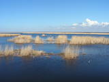 |
Das ist ein flacher, lagunenartiger See, der mit dem ihn umgebenden Feuchtgebiet von internationaler Bedeutung ist. 271 Vogelarten wurden in diesem Gebiet gezählt, einschließlich 43 Vogelarten, die in der Lettischen Roten Liste aufgeführt sind und 15 aus der Europäischen Roten Liste. Zum Park gehören das Nida-Moor und der Teil des Meeres, das sich längsseits des Parks befindet. Zwischen dem Pape-See und der Ostsee befindet sich Lettlands älteste Vogelberingungsstation, wo nicht nur Vögel beringt werden, sondern auch Fledermäuse. Der Pape-See ist das erste Territorium in Lettland, wo Rückzüchtungen von Wildtieren ausgewildert wurden, um die überschwemmten Wiesen des Sees sachgerecht verwalten zu können. Zuerst waren es Wildpferde (Konik-Pferde), dann Auerochsen und der europäische Bison. Durch den Pape-See führt auch Lettlands einzige markierte Wassertourismusroute. Besucher können Vogel- und Naturbeobachtungstürme nutzen, Naturpfade usw. Das Dorf Ķoņi ist ein einzigartiges Beispiel für ein am Meer gelegenes Fischerdorf. Der Pape-See ist unter den Vogelbeobachtern beliebt. Das Besucherzentrum wurde im “Haus der Natur “ des WWF eingerichtet.
|
|
|
|
Līdz 40m augsta ar mežu apaugusi Gaujas labā pamatkrasta nogāze ar vairākiem smilšakmens atsegumiem. Viens no tiem atrodas nogāzes lejasdaļā un veido 7m platu 5m dziļu nišu. Otrā krastā – vairākus metrus augstais Leimaņu iezis. Abi atsegumi atrodas aiz Amatas ietekas.
|
|
 |
Der Pfad beginnt bei Kirche von Krimulda. Er führt am Ufer der Runtiņupīte (Runtiņš) bis zur Mündung in die Gauja. Zu besichtigen sind dort das Pfarrhaus, der Burgberg Kubesele, das Denkaml für das Oberhaupt der Liven - Kaupo, die Kubeseler Höhle, der Felsen Saulstaru, der Große Stein, alte Ankerblöcke, Gräberfelder, ein eigenartiges Labyrinth und anderes.
|
|
 |
Dabas liegums veidots ezera, tā salu, ainavas, augu, putnu un sikspārņu aizsardzībai. Liegumu var apskatīt "no malas" - no ceļa, kas iet gar tā ziemeļu un ziemeļaustrumu robežu.
|
|
 |
Taka izveidota 2005. gadā. Tā atrodas uz Lapmežciema un Bigauņciema robežas un izskatās kā koka dēlīšu laipa gar Siliņupi. Taka aizved līdz jūrai, kur apskatāms vecais Lapmežciema mols. Siliņupē novērojami ūdensputni. |
|


