
| Nr | Name | Beschreibung |
|---|---|---|
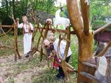 |
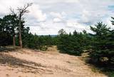
Der Familienpark der Waldweisen in der Hugellandschaft Kaika ist ein Netzwerk von Bauernhöfen und bietet verschiedene Möglichkeiten an, um sich mit gesunden Lebensweisen und der Volksmedizin vertraut zu machen. In den Programmen kann man die Pflanzen- und Blutegelbehandlung, die Zauberreiche von Bienen und Pilzen kennen lernen sowie den Einfluss von Zauberworten und Meditationsorten erleben. Zubereitung von Speisen aus Unkraut, von Hausbrot und Kräuterheilmitteln. |
|
 |
Das größte im Baltikum. Marathonloipe von Tartu, Wand der künstlichen Felsen und Trasse der Radmarathon. Skimuseum. Auf der Tehvandi-Sprungschanze ist ein Aussischtsplatform eingerichtet. |
|
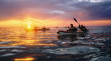 |
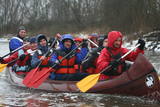
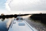
Im Angebot Naturtouren: Flosswanderungen im Frühjahr, Kajaktouren im Sommer (beim Wunsch auch inklusive Biberbeobachtung), ganzjährige Schneeschuhwanderungen in den Moorgebieten von Estland, im Winter Kick-Sled Touren. Erfahrene Wanderführer erzählen spannende Geschichten über die Natur und Kultur von Estland. |
|
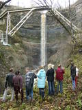 |
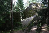
This is a cliff with various levels. Known as the North Estonian cliff, it stretches all along the shore of the Bay of Rīga in Estonia, including some of the local islands. The most expressive part in geological and landscape terms is the Saka-Ontika-Toila cliff, which is around 22 km long and offers an unusual natural environment. The cliff is as much as 53 m high, and it has a fairly virginal forest along its slopes. The layers of clay, sandstone, limestone, etc., come from the Cambrian and Ordovician periods. The Valaste juga (Valaste waterfall) is 24 metres high. After a longer period of freezing temperatures, the waterfall has a particularly impressive appearance. Seasonal waterfalls (8-10 m) can be found near the villages of Ontika and Toila.
|
|
 |
Eine von Nadelbaumwäldern bedeckte Halbinsel. Malerisches Käsmu Steinfeld, Matsikivi Stein, Vana Jüri Stein u.a. Bei passenden Bedingungen kann man sich auf einer steinernen Landzunge bis zur 0,5 km entfernt liegenden Insel Saartneem schleppen. |
|
 |
Angebote zum Natururlaub: Seekajakwanderungen im Sommer, Schneesschuhwanderungen im Moor im Herbst und im Winter, Kanuwanderungen auf Flüssen im Frühjahr |
|
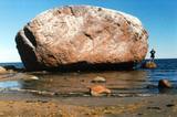 |
This is the largest rock in the Baltic States and, according to some sources, in all of the segment of Northern Europe which was affected by the last Ice Age. Its size is 930 m3! The rock is 7.5 m high, 16.5 m long and 14 m high, with a circumference of 48.5 m. The rock resembles a huge pebble from a distance, and it is on the sandy and rocky beach. Depending on the season, it can be out in the water. The Ice Age carried the rock to its current location from the southern shore of Finland. It is made of pegmatite.
|
|
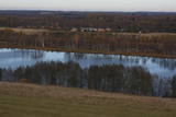 |
This is the most visually impressive drumlin field in the Baltic States, and it is close to the village of Tabivere. The drumlins were established by ice glaciers, and they point in the direction in which the ice moved long ago. In terms of their appearance, the drumlins resemble loaf-shaped hillocks. From their “backs,” there are lovely views of the local landscape and the lakes that are around the area. The visitor centre is in the village of Äksi.
|
|
 |
Ap 6 km garā pussala ir vieta, kur jānokļūst tiem, kas grasās doties vienā no neparastākajiem pārgājieniem pāri jūras šaurumam. Cauri Kūsnemmes pussalai līdz tās ziemeļu daļai iet šaurs un ļoti līkumains grants ceļš (ar garāku tūristu autobusu jābrauc lēni un uzmanīgi), kura galā izveidots autostāvlaukums, neliels namiņš, kur patverties lietus un vēja laikā, kā arī informācijas stends. Turpat redzamas divas Padomju armijas „KRAZ” tipa automašīnas. Lai sasniegtu robežkontroles posteni, Padomju robežsargi brauca pa jūru un mazajām saliņām, kas kā pērļu virtene savieno Kūsnemmes pussalas galu ar Vilsandi salas dienviddaļu. Turpat divas desmitgades pēc Igaunijas neatkarības atjaunošanas „KRAZ” automašīnu kravas kastēs vasaras laikā uz Vilsandi vizināja tūristus, taču spēkrati savu mūžu ir nokalpojuši un unikālais piedāvājums vairs nav spēkā! Ko darīt? Pa mazajām saliņām uz Vilsandi var doties ar kājām. To var īstenot tikai siltā laikā, kad nav gaidāms stiprs vējš un ir zināma laika prognoze vismaz divām tuvākajām dienām. Kā sava veida orientieris var kalpot augstsprieguma elektrolīnija. Kopumā ir jārēķinās arī ar 1 h 40 – 2 h ilgu un ~ 4 km garu gājienu. Dziļākā vieta (ja ietur pareizo „kursu”) atrodas pārgājiena sākumdaļā, kur starp saliņām izveidots laivu ceļš - ~ 1 m dziļa vieta atkarībā no vēja virziena un ūdens līmeņa. Zināmu priekšstatu par maršrutu sniegs redzamā ainava, kas paveras no skatu torņa. Kaut arī šis maršruts tiek reklamēts dažādos informatīvajos materiālos, atbildību par tā veikšanu uzņemas katrs pats! |
|
 |
This is a forested island in the Bay of Finland which is the 6th largest Estonian island and is found 14 km to the N of Tallinn. Two decades ago it was a closed zone, because the Soviet Union had a highly secretive manufacturing plant for maritime mines here.
|
|
 |
This is a quick boat ride from Tartu down the Emajõgi River to Piirissaare Island in Lake Peipsi (Peipsi järv). Along the lower reaches of the river are major wetlands which are of enormous importance for birds.
|
|
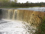 |
Eins der eindrucksvollen Wasserfälle Estlands (ung. 8 m), „wiedererlebt” nach den reichlichen Niederschlägen und im Früfling bei Hochwasser. |
|
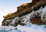 |
Die mächtigste Steilküste im Baltikum (bis zu 24 m hoch). In den kalten Winter werden hier phantastische Gletscherstürze entstanden. Pakri Leuchtturm. |
|
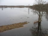 |
Jēsū – Kepu ceļa malā pie Leti (Läti) ciema ir izveidots autostāvlaukums ar putnu vērošanas torni, no kura paveras skats uz Hallistes upes palieņu pļavām un tuvējā ciema apkārtni. Stipru palu laikā arī no šī torņa redzamā apkārtne (izņemot ceļus) var atrasties zem ūdens. Laba putnu vērošanas vieta. Läti tulkojumā no igauņu valodas nozīmē Latvija. |
|
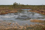 |
Iepazīstina ar Somā nacionālā parka lielākā purva – Kureso (Kuresoo) ziemeļaustrumu daļu, kur redzamas purva ezeriņu un lāmu ainavas. Takas sākumā atrodas igauņu komponista, ērģelnieka un folkloras vācēja Marta Sāra (Mart Saar) (1882. – 1963.) dzimtās mājas. To apkaimē pļavas apsaimnieko aitas. Lokveida takas garums ir 4,2 km. |
|
 |
No Vilsandi bākas un tai tuvākās apkaimes ir labi saskatāmas leģendārās Vaikas salas. Tām ir piešķirts rezervāta statuss, tādēļ salas var apskatīt tikai no attāluma. Mazākā no saliņām - Kullipank ir tikai pārdesmit metrus diametrā. Tā ir jūras ūdeņu izrobots zemas un asas dolomīta klints fragments, kas klāts ar oļiem, nelieliem laukakmeņiem un kādu atsevišķi stāvošu lakstaugu. Domājams, ka vētru laikā tā pazūd zem jūras ūdens. Savukārt, Alumine Vaigas – Apakšējā Vaikas sala ir lielākā no sešām salām. Šīs salas diametrs ir ~ 150 m un tā paceļas vismaz kādus divus metrus virs jūras līmeņa. Uz salas ir bagātīga veģetācija un pat kāds zems krūms salas centrā. Redzami arī metru augsti atsegumi. Uz salas vēl joprojām atrodas 20. gs. sākumā celto „putnu māju” paliekas, kas bija domātas ligzdojošo putnu piesaistīšanai. |
|
 |
Reiterhof Tihuse bietet Reiten (von der Kutschefahrt bis zu Ausritte) und Beherbergung an. |
|
 |
Die Größe dieses Feldsteins ist eindrucksvoll, obwohl er nach dem Volumen (262 m3) nur der 16. größte Feldstein Estlands ist. Die Länge beträgt 10,7 m, Breite – 6,5 m, Umfang – 27,8 m. |
|
 |
Estnische Kleininsel Naissaar war nach dem Zweiten Weltkrieg bis 1993 militärisches Sperrgebiet der sowjetischer Armee. In seiner Zeit – ein geheimes sowjetisches Militärobjekt mit einem Lagerkomplex einer verlassenen Minenfabrik. Besuchenswert auf der Insel sind die artenreiche Natur, Wanderwege, Schmalspurbahn, zaristische Artilleriebatterien und sowjetische Minenfabrik. |
|
|
|
An afforested island in the Gulf of Finland, approximately 14 km to the North of Tallinn. There is a network of small roads and trails on the island. Forests: Mostly 1.1, 1.2 and 4.2. Information: www.aegna.ee. A ferry boat to the island departs from the port at Pirita. Hike around the shore of the island, where you will find all kinds of environments – dunes, sandy areas, rocky areas and places with lots of reeds (~9 km). |
|


