
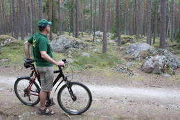
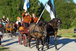
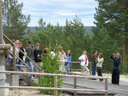
Naturobjekte in Estland

Was ist das Besondere an der Natur in Estland?
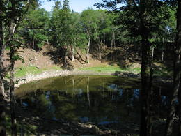
In Estland steht die beeindruckendste Felswand im Baltikum - das sogenannte nordestnische "Glitzern" (aus estnischer Sprache). Estland hat sein eigenes "Land der Buchten" - die Region Lahemaa mit ihrem Nationalpark, das "Land der Inseln" - die Insel Saaremaa und den Monzund-Archipel. Die Matsalu-Bucht ist eine der wichtigsten Raststätten für Vögel während ihrer Wanderung. In Estland gibt es einen der bekanntesten Einschlagkrater in Europa, es gibt die größten Wasserfälle und Felsbrocken im Baltikum, den Munamagi-Hügel - den höchsten Punkt im Baltikum, den Peipus-See - den fünftgrößten See in Europa - mit langen Hervorragende Fischertraditionen und die Vielfalt der Natur von West nach Ost, von Nord nach Süd.
Handle verantwortungsbewusst - folge dem Grünen Rat!
| Überblick | Details |
|---|---|
 |
Estland
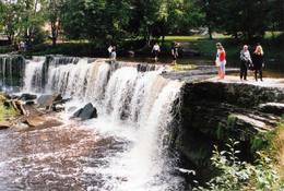
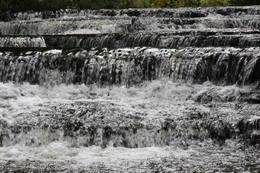
Wasserfall Keila - JoaEins der malerischen Wasserfälle Estlands. Der Wasserfall ist 6 m hoch und fast 50 m breit. Keila-Joa-Park. Leistungen
31km - Entfernung von der HauptstadtLeistungen - erholung
NaturpfadThe rapid Keila River has carved a cliffy canyon behind the waterfall, with a flow of water that falls down a major distance. It’s worth hiking through the Keila park to the shore of the Bay of Finland (~1 km), then returning along the other bank of the river. |
 |
Estland
Anhöhe OtepääEine der drei Anhöhen im Südestland mit malerischen Hügeln und schönen Aussichtsplätzen. Im „Zentrum” der Anhöne legt sich der mit Buchten reiche Pühajärv See (Heiliger See). 230
Leistungen
230km - Entfernung von der Hauptstadt |
 |
Estland
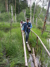
Rebases ainavu taka (Rebäse maastikurada)Ap 7 km garš lokveida pārgājienu maršruts (marķēts), kas ved pa dažādiem biotopiem – mežiem, mitrājiem un pļavām, mezdams līkumus pa stāvo pauguru nogāzēm. Takas malās ir izvietoti informācijas stendi un norādes. Rebases ainavu taka ir domāta tiem, kurus nebaida garāka iešana un orientēšanās pa ļoti dabisku un mazapdzīvotu apvidu. |
 |
Estland
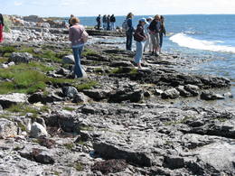
Vilsandi sala (Vilsandi saar)Vilsandi nacionālā parka „sirds” un divpadsmitā lielākā Igaunijas sala (garums - 6 km, platums – 2 km). Tā ir ļoti „jauna” sala, kas sākusi veidoties pirms ~ 2000 gadiem zemes garozas celšanās rezultātā, savienojoties divām salām, kas noticis pirms ~ 350 gadiem. Cilvēki salu sāka apdzīvot 18. gs. un to galvenā nodarbe bija zvejniecība, kuģu būve, nelielā apjomā – lauksaimniecība. Līdz 2. pasaules karam te bija ap 200 iedzīvotāju, kuri vēlāk salu bija spiesti pamest PRSR pierobežas režīma zonas dēļ. Nozīmīgu Vilsandi daļu aizņem mežs un kadiķu lauki. To visā garumā šķērso grantēts - zemes ceļš ar atzariem uz jūras krastu. Salu ar kājām var izstaigāt vairāku stundu laikā, iepazīstot vietējo apbūvi (daļa arī mūsdienās celtas ēkas) un Tolli sētu, kur pēc nostāstiem dzīvojis nīderlandiešu jūras braucējs Johans Dolls, kā arī vējdzirnavas. Noteikti ir jāaiziet līdz salas rietumu krastam, kur atrodas Vilsandi bāka un bākas uzrauga saimniecības ēkas. No šejienes ir labi redzamas Vaikas salas. Šodien uz salas pastāvīgi (visa gada garumā) dzīvo tikai trīs cilvēki. |
 |
Estland
Eldas klints (Elda pank) un pussalaNacionālā parka dienvidrietumdaļā jūrā iestiepjas Eldas pussala – skaists un ļoti omaļš ar kadiķu mežu (alvāriem) noaudzis zemes pleķītis ar interesantu jūras krastu, kur atsedzas silūra perioda nogulumieži. No pussalas gala, kurā slejas vecs Padomju armijas robežsargu tornis (apmeklējumam bīstams!), paveras visaptverošs skats uz Vilsandi salu (atpazīstama pēc bākas), Lonalaidas salu (Loonalaid) – otru lielāko Vilsandi arhipelāgā, Salavu (Salava) un citām mazākām saliņām. Dabas mīļotāji var uzmeklēt Eldas klinti (Elda pank) – ~ 2 m augstu un 0,4 km garu atsegumu, kura piekājē var atrast interesantas ūdens izskalotas fosilijas. 261
Leistungen
261km - Entfernung von der Hauptstadt |
 |
Estland
Halbinsel KäsmuEine von Nadelbaumwäldern bedeckte Halbinsel. Malerisches Käsmu Steinfeld, Matsikivi Stein, Vana Jüri Stein u.a. Bei passenden Bedingungen kann man sich auf einer steinernen Landzunge bis zur 0,5 km entfernt liegenden Insel Saartneem schleppen. 81
Leistungen
81km - Entfernung von der Hauptstadt |
 |
Estland
Nemmeveski udenskritums (Nõmmeveski juga)No vairākiem parka ūdenskritumiem noteikti ir jāapmeklē divi. 1,2 m augstais vienpakāpes Nemmeveski ir izveidojies uz Valgejegi upes (Valgejõgi), vietā kur tā šķērso Ziemeļigaunijas glintu. Šeit Valgejegi atgādina krāčainu (īpaši – pavasaros) kalnu upi, kas plūst pa vairākus metrus augstu klinšu ieskautu kanjonu. Palu laikā šo upes posmu ir iecienījuši ekstrēmie ūdenssporta veidu cienītāji. Pie ūdenskrituma un tālāk pa upi lejup redzamas ap 1920. g. celtās hidroelektrostacijas konstrukciju paliekas. |
 |
Estland
Nationalpark VilsandiWurde für den Schutz der Inselgruppe Vilsandi (ung. 100 kleine Inseln) gegründet. Die größte ist 6 km lange un bis 2 km breite Vilsandi Insel. Leistungen
255km - Entfernung von der HauptstadtLeistungen - erholung
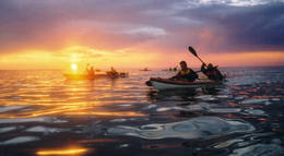
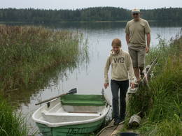
Fahrten mit Schiff/BootBoat along the islands of the archipelago, but keep in mind that the Vaika Island and the Nootamaa Island are nature reserves which are closed to visitors.
NaturpfadHike the route Loona-Kuusnõmme (8 km), hike around the Vilsandi Island (~12-15 km), hike the Harilaid peninsula (~10 km). 
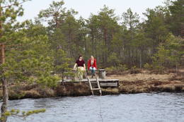
NaturbeobachtungBird-watching from the southern end of the Vilssandi Island – the nearby Vaika Island is closed to visitors. There is a viewing tower on the N end of the Kuusnõmme peninsula. The visitor centre of the park is found at the Loona estate (Loona mõis). |
 |
Estland
Leti tornis (Läti torn)Jēsū – Kepu ceļa malā pie Leti (Läti) ciema ir izveidots autostāvlaukums ar putnu vērošanas torni, no kura paveras skats uz Hallistes upes palieņu pļavām un tuvējā ciema apkārtni. Stipru palu laikā arī no šī torņa redzamā apkārtne (izņemot ceļus) var atrasties zem ūdens. Laba putnu vērošanas vieta. Läti tulkojumā no igauņu valodas nozīmē Latvija. |
 |
Estland
Nationalpark MatsaluDer Nationalpark Matsalu (48 610 ha) wurde als Schutzgebiet für die zahlreichen Vogelarten eingerichtet. Im 1976 wurde Matsalu zu der bedeutendsten Feuchtgebiete der Welt aufgenommen und auf die Ramsar Liste eingetragen. Matsalu ein wichtiger Zwischenstopp für Zugvögel und ein Nistplatz für viele Watvögel und gehört zu den populärsten Vogelbeobachtungsgebieten in Europa. Hier gibt es viele Naturpfade und 8 Vogelbeobachtungstürme. Vogelbeobachtungstouren und Pauschalen für Familien, sowie Kanuwanderungen in Matsalu bietet der Reiseveranstalter Estonian Nature Tours (www.naturetours.ee). Leistungen
1-12 Aktive SaisonmonateLeistungen - erholung
Fahrten mit Schiff/BootBoating on the Bay of Matsalu and the Kasari River can be organised.
NaturpfadThe Kiideva-Puise hiking trial (5 km), the Penijõe trail (3 km), the Salevere information trail (1.5 km).
NaturbeobachtungBird-watching is possible throughout the park, especially on the shorelines, in wetland meadows and heaths. There are bird-watching towers or platforms at Puise, Kiideva, Haeska, Rannajõe, Kasari jõgi, Penijõe, Suitsu and Keemu. The visitor centre is in the village of Matsalu. For more information: www.matsalu.ee (available in English). |
 |
Estland
Insel NaissaarEstnische Kleininsel Naissaar war nach dem Zweiten Weltkrieg bis 1993 militärisches Sperrgebiet der sowjetischer Armee. In seiner Zeit – ein geheimes sowjetisches Militärobjekt mit einem Lagerkomplex einer verlassenen Minenfabrik. Besuchenswert auf der Insel sind die artenreiche Natur, Wanderwege, Schmalspurbahn, zaristische Artilleriebatterien und sowjetische Minenfabrik. 12
1-12
Leistungen
12km - Entfernung von der Hauptstadt
1-12 Aktive Saisonmonate |
 |
Estland
Aegna IslandThis is an entirely forested island in the Bay of Finland, ~14 km from Tallinn. A network of small pathways covers the entire island. Recommended hike along the seashore of the island, which will offer dunes, as well as a coastline that is sandy in some parts, rocky in others, and covered with reeds in still others (~9 km). A ferry boat will take you to the island from the Pirita port.
|
 |
Estland
Suitsu tornis (Suitsu torn)Suitsu tornis celts 1979. g. kā pirmais Matsalu rezervāta metāla tornis. To atjaunoja 1998. g. Torņa augstums ir 21 m, tādēļ no tā paveras izcila dabas un kultūrainava uz Kazari deltas niedrājiem un blakus esošo Suitsu upi (Suitsu jõgi), kuras krastā ir uzceltas vairākas zvejnieku laivu būdas. |
 |
Estland
Naturschutz-gebiet ViidumäeWurde für den Schutz der seltenen Pflanzenarten (auch endemische) und Biotopen an der alten Uferlinie vom Ancilus See gegründet. Leistungen
244km - Entfernung von der HauptstadtLeistungen - erholung
NaturpfadThe Viidumäe educational trail (1.2 km), the Audaku hiking trial (2.8 km).
NaturbeobachtungThere is a viewing tower on Mount Viidumägi with a broad view of the western end of the Saaremaa Island. It’s worth visiting the visitor centre at Audaku. |
 |
Estland
Reiterhof Tihuse altertümlicher KulturpfadReiterhof Tihuse bietet Reiten (von der Kutschefahrt bis zu Ausritte) und Beherbergung an. 148
1-12
Leistungen
148km - Entfernung von der Hauptstadt
1-12 Aktive Saisonmonate |
 |
Estland
Reimann Retked NaturtourenIm Angebot Naturtouren: Flosswanderungen im Frühjahr, Kajaktouren im Sommer (beim Wunsch auch inklusive Biberbeobachtung), ganzjährige Schneeschuhwanderungen in den Moorgebieten von Estland, im Winter Kick-Sled Touren. Erfahrene Wanderführer erzählen spannende Geschichten über die Natur und Kultur von Estland. 34
1-12
Leistungen
34km - Entfernung von der Hauptstadt
1-12 Aktive Saisonmonate |
 |
Estland
Erdi taka (Öördi rada)1,2 km gara taka, kas pa purvainu mežu aizved līdz Ērdi purvam (Öördi raba) un tā austrumu daļā esošajam Ērdi ezeram (Öördi järv), pie kura izveidota atpūtas un peldvieta. |
 |
Estland
Insel PiirissaareInsel Piirissaare im Peipussee hat eine Fläche von 7,5 km². Die Inselbewohner sind grossenteils ussische Altgläubige. Die alte Kultur ist während Jahrhunderten gut erhalten geblieben. Die Hauptbeschäftigung der Inselbewohner ist Fischfang. Auf den Feldern wird Gemüse, hauptsächlich Zwiebel angebaut. 262
1-12
Leistungen
262km - Entfernung von der Hauptstadt
1-12 Aktive Saisonmonate |
 |
Estland
Joaveski udenskritumi (Joaveski joastik)Krāčains Lobu upes (Loobu jõgi) posms pie Joaveski ciema, kur ~ 160 m garumā upes gultnē, tai šķērsojot Ziemeļigaunijas glintu, izveidojušās izmēros nelielas, tomēr ļoti ainaviskas un skaistas 0,5 – 1 m augstas ūdenskritumu kaskādes. 1898. g. šeit uzcēla hidroelektrostaciju, kuras atliekas ir redzamas upes labajā krastā. Iecienīta pavasara laivotāju treniņu vieta. |
 |
Estland
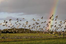
Putnu verosanas tornis Puises ragaPuises ragā (Puise nina) ir uzcelts divstāvīgs atpūtas nams, kas apvienots ar putnu vērošanas torni. No tā paveras skats uz piekrasti, kas ir iecienīta migrējošo zosu atpūtas vieta. Šī ir privāta teritorija, kuras apskati vēlams saskaņot ar īpašnieku. 123
Leistungen
123km - Entfernung von der Hauptstadt |
 |
Estland
NaisaarThis is a forested island in the Bay of Finland which is the 6th largest Estonian island and is found 14 km to the N of Tallinn. Two decades ago it was a closed zone, because the Soviet Union had a highly secretive manufacturing plant for maritime mines here.
LeistungenLeistungen - erholung
Radroutea route around the entire perimeter of the island (~20 km). A ferry boat will take you to the island from the Pirita port.
NaturpfadThere is a hiking route along the southern part of Naisaar Island (13 km), as well as a military route (10 km), a central route (11 km)
Naturbeobachtung |
 |
Estland
Ehijervs (Ähijärv)Karulas nacionālā parka lielākais ezers - 2,8 km garš, līdz 1 km plats. Ezera ziemeļaustrumu krastā atrodas parka apmeklētāju centrs. 5,5 m dziļais ezers ir gan zivīm, gan nostāstiem bagāta vieta. Ezera un tuvākās apkārtnes iepazīšanas nolūkā ir izveidota 3,5 km garā Ehijerva taka (Ähijärve teerada). Tās sākums atrodas pie iepriekš minētā apmeklētāju centra, kur izveidota atpūtas vieta un atraktīvs bērnu spēļu laukums. Taka sākumā ved gar ezera krastu, nelieliem mitrājiem un meža ceļiem, kas izmantoti iepriekšējos gadsimtos. |
 |
Estland
Meteoritenfeld von Kaali, Besucherzentrum, Wirtshaus KaaliDer Meteoriteneinschlag auf Insel Saaremaa liegt ungefähr 7500-7600 Jahre zurück und verursachte einen Krater von 110 m Durchmesser und 22 m Tiefe und 8 weiter kleine Krater. In der Rangliste der Riesenkrater der Welt liegt der Kaali Krater an achter Stelle. Das Kaali Meteoritenkraterfeld auf Saaremaa ist das seltenste Naturdenkmal Estlands und gleichzeitig das eindrucksvollste Kraterfeld in Eurasien. Auf dem Kraterfeld befindet sich das Besucherzentrum von Kaali samt dem Museum für Meteoritik und Kalkstein, einem Konferenzsaal und dem Hotel. Im Museum sind echte Meteoritenstücke ausgestellt. Im Hotel sind kompfortable Zimmer, nebenan befindet sich historisches Wirtshaus Kaali. 204
1-12
Leistungen
204km - Entfernung von der Hauptstadt
1-12 Aktive Saisonmonate |
 |
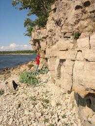
Estland
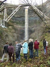
Saka-Ontika-Toila-pank (cliff)This is a cliff with various levels. Known as the North Estonian cliff, it stretches all along the shore of the Bay of Rīga in Estonia, including some of the local islands. The most expressive part in geological and landscape terms is the Saka-Ontika-Toila cliff, which is around 22 km long and offers an unusual natural environment. The cliff is as much as 53 m high, and it has a fairly virginal forest along its slopes. The layers of clay, sandstone, limestone, etc., come from the Cambrian and Ordovician periods. The Valaste juga (Valaste waterfall) is 24 metres high. After a longer period of freezing temperatures, the waterfall has a particularly impressive appearance. Seasonal waterfalls (8-10 m) can be found near the villages of Ontika and Toila.
LeistungenLeistungen - erholung
RadrouteBike from Saka to Taoil (20 km) along the road that is at the top of the cliffs.
NaturpfadHike along the seashore during the season when trees are bare, moving from Saka to Toila (~22 km).
NaturbeobachtungThere is an impressive viewing platform at the Valaste waterfall. |
 |
Estland
Mejekoses pargajienu taka (Meiekose matkarada)~ 3 – 5 km gara taka, kas ved pa veco ceļu gar Tēramā upes (Tõramaa jõgi) kreiso krastu. Takas malās izvietoti interaktīvi elementi bērniem, kas palīdz labāk uztvert dabā notiekošo. Taku ieskauj mitrie meži un palieņu pļavas, kas palu laikā atrodas zem ūdens. Tēramā (Tõramaa) ciemā apkārtnē atrastas cilvēka darbības pēdas jau no akmens laikmeta. 149
Leistungen
149km - Entfernung von der Hauptstadt |
 |
Estland
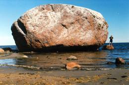
The Letipea Ehalkivi rockThis is the largest rock in the Baltic States and, according to some sources, in all of the segment of Northern Europe which was affected by the last Ice Age. Its size is 930 m3! The rock is 7.5 m high, 16.5 m long and 14 m high, with a circumference of 48.5 m. The rock resembles a huge pebble from a distance, and it is on the sandy and rocky beach. Depending on the season, it can be out in the water. The Ice Age carried the rock to its current location from the southern shore of Finland. It is made of pegmatite.
|
 |
Estland
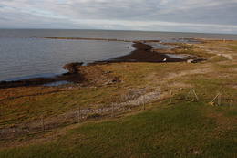
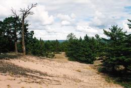
LuitemaaThe word “Luitemaa” means “land of the dunes” in Estoninan. This coastline territory stretches for 13 km between Vöiste and Häädemeste with shallow waters, large coastal plains, Estonia’s highest dunes, and the Tokuse swamp (Tokuse raba). There are lots of birds here.
|
 |
Estland
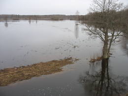
Penije tornis (Penijõe torn)Lai nokļūtu līdz šim tornim, ir jāveic apmēram 20 – 30 min ilgs pārgājiens pa dabas taku no Penijē muižas gar Penijegi (Penijõgi) kreiso krastu. Te redzami bebru darbi un to celtās zaru mājas. No torņa paveras skats uz Kazari deltu, kas dabā izpaužas kā monolīts un nepārskatāms niedrājs. To vairākās daļās sadala Kazari un mazāka izmēra upītes. Katrai deltas daļai ir savs vēsturiskais nosaukums: no torņa pa kreisi no Penijegi redzama Lihula meri (Lihulas „jūra”), bet tās labajā pusē - Kloostri meri (Klostri „jūra”). Putnu vērotāji var iziet garāku (7 km) dabas takas loku, kas ved pa palieņu pļavām. Jārēķinās, ka pavasaros būs nepieciešami piemēroti apavi! Pļavas ierobežotās platībās apsaimnieko mājdzīvnieki, tādēļ neaizmirstiet aizvērt vārtiņus aiz sevis un netraucējiet to ikdienas gaitas! No maršruta nav atļauts novirzīties, lai netraucētu putnus. |
 |
Estland
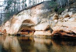
Ancient Võhandu River valleyThis is one of the most beautiful ancient river valleys in Estonia – 12 km long with nearly 40 revealed Devonian sandstone cliffs. Among these, the most important ones are Viira müür, Kalamatu müür, and Põdramüür.
|
 |
Estland
Terama taka (Tõramaa matkarada)Divarpus kilometrus gara taka (vienā virzienā) aizved līdz Hallistes palieņu pļavām, kur Hallistes upes labajā krastā ir uzcelts divstāvīgs koka skatu tornis. No tā paveras visaptverošs skats uz atjaunotajām (izcirsti krūmi) Hallistes palieņu pļavām. Pavasara palu laikā no torņa redzamā apkārtne un tornis atrodas ūdenī. |


