
| Nr | Name | Beschreibung |
|---|---|---|
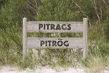 |
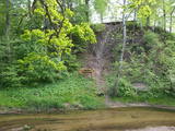
Zum ersten Mal wurde das Dorf im Jahr 1582 urkundlich erwähnt. Auf den Sandbänken in der Nähe von Pitrags liegen viele versunkene Schiffe. Im Jahr 1826 wurden in Pitrags elf Bauernhöfe und 190 Einwohner registriert. Um die Mitte des 19. Jh. wurde hier ein Wirtshaus eröffnet. 1937 gab es im Dorf 12 alte Bauernhöfe und 38 Fischerhöfe (vor allem neue Bauernhöfe). Im Dorf gab es mehrere Fischverarbeitungsstellen. In Pitrags lebte die hervorragende Erzählerin der livischen Sprache Marija Šaltjāre (Bertholde, 1860–1930), die mehr als 200 Märchen und Sagen, mehr als 90 Lieder, Spiele, etc. veröffentlicht hat. Das Baptisten-Gebetshaus von Pitrags wurde 1902 erbaut. Während des Ersten Weltkriegs brannte es aus, wurde 1925 wiederhergestellt und Ende des 20. Jh. renoviert. Im Zentrum von Pitrags im Bauernhof Krogi sind 27 Muster der Zäune von der Livischen Küste ausgestellt und hier werden auch Fischräucherei und Verkostung angeboten. |
|
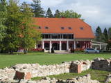 |
Etwa eine Autostunde von Riga entfernt, auf dem Gelände des alten Landguts Anna befindet sich das international renommierte Designhotel Annas Hotel. Inspiriert von alten Traditionen der lettischen Küche kreiert der Küchenchef jeden Tag ein neues Menü und lässt die Gäste immer eine besondere und ungewöhnliche Mahlzeit genießen. Lettische Küche: Brühe mit Pfifferlingen, Speisen aus Kaninchenfleisch. Das besondere Gericht: Suppe aus Heidelbeercreme mit Eis aus Quark. |
|
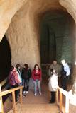 |
The area of the ancient Piusa River valley that is between the villages of Vana-Vastseliina and Ignasõ is around 15 km long, features some substantial rapids, and offers a view of beautiful Devonian period cliffs. The largest, Härma müür, is 43 metres high and is the highest sandstone cliff in Estonia. There are caves from old mines in the village of Piusa. A small part of the mines, which have tunnels that are more than 10 km long in all, has been tured into a local museum.
|
|
 |
From the Markova castle hill, which you will access from the local information trial, you will see a view of the Daugavsargi curve of the Daugava. Further along, you will reach the open shore of the Daugava to see one of the most unique landscapes of Latvia’s river valleys. The Slutišķi village of Old Believers and the mighty Slutišķi cliff will be in the background.
|
|
 |
On the left bank of the Gauja River, opposite the Piķene cliff is the mighty Beite cliff which is split by a deep ravine. On the left side there is Ķeizarskats (Emperor's View), which is approximately 67 metres above the level of the Gauja and offers a fine view of Krimulda and the Turaida Castle. The viewing place was installed in 1862, when Russian Tsar Alexander II visited Sigulda. On the right side of the ravine is the mighty wooden Ķeizarkrēsls (Emperor's Chair). To get there, you have to cross the ravine (there are wooden stairs and a forest trail). You can go around it on Laurenču, Kalna and Gulbju streets. |
|
 |
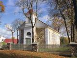
All Saints Orthodox Church of Malta (Rozentova) was built in
1928. It is the wooden log building with double window frames and a
dome. Facades are decorated with the motive of the sun.
|
|
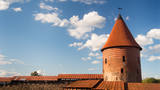 |
Kaunas Castle is the oldest stone castle in Lithuania and interestingly enough, the museum that is inside is also the oldest one in Lithuania. It's possible to take a tour to get know more about Kaunas Castle and also visit the museum where there's not only information about the castle but also about the city of Kaunas itself and much more. |
|
 |
Auf der Käsefarm Andre werden Käse hergestellt und verkauft, die in der ganzen Welt eine hohe Bewertung erhalten haben. Qualitative und leckere Milch wird von den glücklichen Farmkühen erhalten. Farmgäste können die Kühe besuchen und streicheln sowie den Melkvorgang beobachten. Im kleinen Bauernladen kann man sowohl Käse als auch Bioprodukte anderer örtlicher Kleinhersteller kaufen. |
|
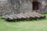 |
The Bauska Castle contains a collection of cast iron cannons which date back to the latter half of the 17th century and the beginning of the 18th century. They were manufactured in the Duchy of Courland. The cannons that are in the garden of the castle were not found there – they were found in different locations in Zemgale. Four of the largest cannons came from Jaunsvirlauka, where they were found on the banks of the Lielupe River opposite Emburga. They are the best preserved weapons of their type in Latvia. The only cannon that was found in the castle itself is currently in its South-eastern tower as a thematic exhibit. When it was being cleaned, two cannonballs were found in the weapons. The local Livonian Order castle is in ruins, but it and its defensive structures, including earthen ramparts that were installed from the mid-15th until the early 18th century, represent an important element of Latvia’s military heritage.
|
|
 |
Der Vilce Naturpark ist klein und verläuft entlang der tiefen Tälern des Vilce - Flusses und seinen Nebenflüssen. Die Biotope umfassen Sandsteinklippen, Stromschnellen, Wälder, die für solche Gegenden typisch sind und die entsprechenden Pflanzen und Tiere darin. Der gut hergerichtete Burgberg von Vilce liegt neben der Zaķu-Wiese, die ein hübsch gestalteter und beliebter Platz zum Ausruhen ist.
|
|
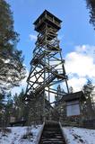 |
This recently built 26-metre wooden tower is on Ūdri Hill (58 metres above sea level). It is on the north-eastern shore of Lake Usma, less than one kilometre from the lake. The tower offers an excellent view of Lake Usma, its islands, and the vast forests which surround it.
|
|
 |
Ventspils Vecpilsētas vēsturiskais centrs. Nelielā Rātslaukuma (40 x 60 m) rietumu malā atrodas Starptautiskā rakstnieku un tulkotāju māja, kas ierīkota 18. gs. dzīvojamā ēkā ar baroka un klasicisma iezīmēm (19. gs. vidū te atradās pilsētas Rātsnams), bet austrumu malā – vēlīnā klasicisma stilā celtā evaņģēliski luteriskā Nikolaja baznīca. Iepretim baznīcai atrodas modernā stilā pārbūvētā Ventspils Galvenā bibliotēka un Digitālais centrs, kas ierīkots greznā 19. gs. savrupmājā. |
|
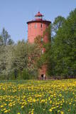 |
Der zweitälteste Navigationsbau in Lettland, und der einzige, der sich 5 km vom Meeresufer entfernt an der obersten Seite des Baltischen Eissees befindet. Seit 2000 wird die Funktion des Leuchtturms hier nicht mehr erfüllt, stattdessen ist hier nun das Naturbildungszentrum „Slītere“ des Nationalparks Slītere untergebracht. Hier kann man Ausstellungen über lettische Leuchttürme und die Geschichte der Ostsee sehen. Aus dem obersten Geschoss (102 m über dem Meeresspiegel) kann man die Küste der Insel Saaremaa (ca. 33 km entfernt) sehen. Neben dem Leuchtturm verläuft der 1,2 km lange Slītere Naturpfad. |
|
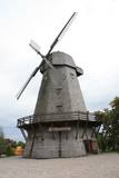 |
Die Windmühle ist von 1867 bis 1869 im holländischen Stil gebaut worden. Der Namen erwarb die Windmühle nach dem Familienname des ersten Besitzers – Riba. Die Windmühle ist eins der besser erhaltenen Architekturdenkmäler dieser Typs in Lettland. Auf der Windmühle ist die dauerhafte Exposition “Der Weg vom Getreide” errichtet, die über landwirtschaftliche Entwicklung in Semgallen, die Traditionen der Getreidezucht und des Brotbackens erzählt. Es werden Exkursionen mit Guidebegleitung angeboten. Die Windmühle gehört zum Erholungskomplex (Hotel, Restaurant, Mühle) „Rožmalas”. |
|
 |
St. John the Baptist Roman Catholic Church of Nagļi was built
in 1862 by landlord Nābels. Some time ago, Nagļi Church was a branch of Viļāni Church. The Bernardian
monks served there. After the closing of the cloisters in 1930s, the church was served by priests.
|
|
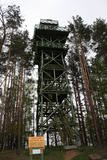 |
Viens no diviem nacionālā parka skatu torņiem, kas atrodas ~ 1,5 km ziemeļos no Ehijerva ezera (Ähijärv). Tornis ir veiksmīgi „nomaskēts” nelielā priežu pudurī, tādēļ tas „nebojā” izcilo dabas un kultūrainavu, kas paveras no tā skatu platformas. Pie autostāvlaukuma ir izveidota labiekārtota atpūtas vieta. |
|
 |
Ein nettes Café, das sich im alten Volkshaus befindet. Darin werden einzigartiger Käse, Teigtaschen, Suppe aus Pfifferlingen, Bohnen und Graupen, vadsas, Getränk aus Mädesüß-Sirup zubereitet. |
|
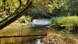 |
Cecīļu dabas taka ir kājāmgājēju tūrisma maršruts, kurā ir iespēja iepazīt Amatas novada dabas objektus gar Kumadas upes, Dančupītes un Amatas upes krastu. Takas sākuma punkts ir Amatas novada Ieriķos, 1 km no kafejnīcas, degvielas uzpildes stacijas, Cecīļu dabas takas apmeklētāju centra, blakus autoservisam. Apmeklētājiem ir iespēja izbaudīt cilvēka nepārveidotu dabas ainavu – Dančupītes kanjonu, minatūru ūdenskritumu, no Kumadas upes labā krasta aplūkot iespaidīgo Cecīļu iezi un citus objektus. Taka ir marķēta. |
|
 |
In 1951, when it died, the pine tree had a circumference of 4.63 metres. It was the thickest pine tree in the Baltic States
This is one of the few trees with such a long history for which age has been determined by counting up circles – 370 years. All that’s left is a conserved part of the stump at the side of the road. Cross-sections of the stump are on exhibit at the Latvian Museum of Nature and the Latvian Ethnographic Open-Air Museum.
|
|
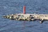 |
Für Reduzierung der Verschlammung der Flussmündung und Regelung des Flusslaufes wurde im Mitte des 19. Jahrhunderts die Ostmole in der Länge von 980 Meter gebaut. Eine Holzpfahlbauweise bildet die Gründung der Mole, die mit Steinen bedeckt ist. Die 2,2 km lange Mole ist heutzutage rekonstruiert und dient als beliebter Platz für Spaziergänge, Erholung und Angeln in allen Jahreszeiten. Von der Mole kann man Vögel beobachten, von Zeit zu Zeit kann man Glück haben und eine Robbe beobachten. Am Anfang der Mole sind zwei Gedenksteine mit Inschrift zu sehen. Die Inschrift lautet, dass den Bau der Mole der Kaiser Alexander II. von Russland (1856) und seinen Thronfolger Nikolaus Alexandrowitsch (1860) besucht haben. Dieses Ereignis erhöht die Bedeutung des Rigaer Hafens im Kontext der damaligen Ostseehandelswege. |
|


