
| Нo | Название | Описание |
|---|---|---|
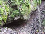 |
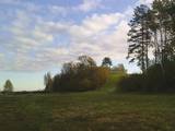
Городище Опинки – имеющее особое значение населенное
место древних латгальцев. На правом берегу реки Вицес обра-
зовалась Чертова пещера, называемая и малым Стабурагом Лат-
галии. Небольшая пещера (длина 3 м, ширина 2 м, высота 0,6 м) геологически уникальна тем, что она
образовалась естественным путем в четвертичный период, сцементировавшись из ссохшегося гравия.
Таких пещер в Латвии только две.
|
|
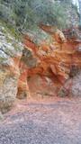 |
Sarkanās klintis savu vārdu ieguvušas pateicoties sarkanajiem iežiem. Tieši sarkanā ir mīlestības krāsa, tāpēc sarkanās klintis ir romatiska pastaigas vieta mīlniekiem. Smilšakmens klintīs redzamas plaisas, kas sašķeļ sarkanīgos iežus, radot neparastu dabas mākslas darbu. To virsma ir diezgan izrobota, kas veido klintīs nelielas alas un nišas. Sarkanajās klintīs ir arī daudz dažādu avotiņu. Pazīstamākais no tiem ir Rūcamavots. Tam ir šāds nosaukums, jo tas, nākot ārā no zemes, izdod nelielu rūkoņu. |
|
 |
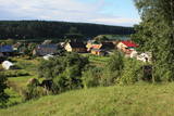
Atrodas ~ 1,5 km ziemeļos no Krāslavas centra, Jāņupītes krastā (ir norāde). Pēc atsevišķiem savrupatradumiem var spriest, ka pilskalns apdzīvots laikā no I g. t. pr. Kristus līdz vēlajam dzelzs laikmetam. Domājams, ka savu nosaukumu tas ieguvis šeit sastopamo mālu dēļ. Nelielas mālu ieguves vietas pilskalna nogāzēs ir redzamas arī šodien. Saglabājies nostāsts, ka grāfs Plāters šeit apraudājis savu sievu, kuru pats neuzticības dēļ licis iemūrēt pazemē. |
|
 |
Where the little Rumbiņa river flows into the Daugava (on the left bank of the little river opposite the Lielvārde park), there is the Dievkalns castle hill that has been reduced by the waters of the Daugava. It is also known as the Cepure hill. According to antiquities that have been found here, representatives of Baltic tribes lived here from the first millennium BC to the 6th or 7th century AD. The level of the Ķegums hydroelectric power plant can be reached by a staircase from which the best view of this object can be found.
|
|
 |
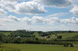
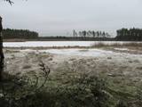
Городище Иденя расположено на северо-западном склоне озера
Лубана. С него открывается прекрасный вид на озеро и
болотистую местность вокруг озера. Заселено в 11 веке.
|
|
 |
Iespaidīgs pilskalns ar izveidotu apskates taku. Blakus ūdenstūristu apmetne „Kvēpene”.
|
|
 |
Karņicka kalns pēc savas izcelsmes nav kalns, bet gan Daugavas ielejas nogāzes daļa ar labu skatu uz Krāslavas mazstāvu koka apbūvi. Ar šo vietu saistīts traģisks nostāsts par poļu virsnieka Josifa Karņicka un grāfa Plātera meitas mīlestību, kurai nebija lemts piepildīties tā laika „paražu” dēļ. Tā rezultātā abi nelaimīgie nolemj izdarīt pašnāvību. Virsnieks nošaujas, bet Emīliju pēdējā brīdī izglābj kalpone, neļaujot tai izlēkt pa pils logu. J. Karņicka pašnāvības vietā ir uzstādīts piemineklis. Nedaudz tālāk – rietumu virzienā guļ t.s. Austriņa akmens, pie kura 1909. gadā iedvesmojies un radījis latviešu rakstnieks Antons Austriņš. |
|
 |
Sens pilskalns Abavas kreisā senkrasta nogāzē. Pēc sena nostāsta zviedru karavīri ar savām cepurēm to sabēruši virs sava ģenerāļa kapa. Tagad Zviedru cepures apkārtnē ziemā var braukt pa kalnu slēpošanas trasēm, bet vasarā – ar rodeļiem.
|
|
 |
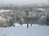
This restricted area protects the highest hillock in the Alūksne highlands – Dēliņkalns Hill – as well as the biotopes on its hillsides. The local landscape is also protected. Downhill ski trails are on the mountain, and its southern side offers lovely views.
|
|
|
|
Одна из наиболее высоких дюн нашего побережья. В советское время в дюне велись копательные работы, так как песок использовался для производства силикатного кирпича. В 80-е годы ХХ века копательные работы были прекращены. Самая высокая часть дюны (хороший вид) сохранилась и поросла сосновым лесом. Создана природная тропа горы Пусену. Находятся в Бернатском природном парке. |
|
 |
This is one of the most impressive and extensive natural structures of its kind in Latvia in terms of appearance and landscape. The ice age left behind this wall-like terrain, which is up to 27 metres high and at the top of which the Rīga-Ērgļi road has been built. The Great Kangari hills offer a view of the Great Kangars lake and the Great Kangari swamps and ponds. The Ķoderi castle hill, also known as the “Big Man’s Bed” is found here. The restricted area was established to protect the structure and its related biotopes and plants.
|
|
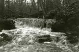 |
Here we find a set of canyon-type gullies among layers of dolomite. There are impressive outcrops and small waterfalls in the little river’s bed.
|
|
|
|
The restricted area was set up to protect Nesaule Hill, which is a forested hillock in the area and features boreal and damp forests.
|
|
 |
Лустужкалнс в 16 ст. на высоком холме
(72 м н.у.м.) находился охотничий замок
магистра Ливонского ордена Вальтера фон
Плетенберга. В свою очередь, построенный
во время Русской императрицы Екатерины
дворец развлечений, от которого и пошло
название и легенда о затонувшей золотой
карете в озере Валгума.
|
|
|
|
Opekalns (arī Apukalns, Opekols) ir paugurs Alūksnes augstienē, 235 metrus virs jūras līmeņa, Veclaicenes pauguraines viena no augstākajām virsotnēm. Tā virsotnē uzcelta Opekalna luterāņu baznīca (1774—1779), kas ir visaugstāk virs jūras līmeņa novietotais dievnams Latvijā. Opekalna ciemā dzimis leģendārais Dziesmu svētku virsdiriģents Haralds Mednis. |
|
 |
Городище Спринги pасположено недалеко от города Резекне и
вызывает интерес своеобразной формой. Археологический
памятник местного значения.
|
|
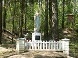 |
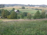
Городище Милкас находится на северном берегу залива западной
части озера Салайс, неподалеку от истока реки Малты. Гора поднимается
на 27 м над уровнем озера. Склоны городища крутые одинаково, только
восточная сторона более покатая. Местный предприниматель привел в
порядок городище и установил на нем статую Богоматери, свидетельству-
ющую о вере местных жителей Богоматери и убежденностью в существование Бога.
|
|
 |
Gaiziņkalns Hill is the highest hill in Latvia, and it is a typical example of the hillocks of the Vidzeme highlands. This is a place of wonderful landscapes, even though there are not all that many good viewing areas. At the centre of this park is Gaiziņkalns Hill itself – the highest place in Latvia and the second highest in the Baltic States (311.6 metres above sea level). The viewing tower, alas is not open to the public, because it is in dangerous condition. There is a well-appointed hiking trail around Gaiziņkalns Hill, and during the winter the hill and its surroundings are popular for downhill and cross-country skiing. Lake Viešūrs (Lake Kaķītis) is popular among licensed fishermen. This territory is part of a region of protected landscapes around Vestiena. |
|
 |
Volzbahs ir stāva nogāze ar elpu aizraujošu skatu pāri gravai. Ziemā šeit pieejams vairāk nekā 100 m garš nobrauciens ar slēpēm, sniega dēli vai ragaviņām. Citos gadalaikos Volzbaha kalns ir lieliska atpūtas vieta- šeit ir labiekārtota vieta piknikam, pastaigām, foto sesijām. Rudenī Volzbaha kalns ir viena no labākajām vietām Vaiņodes novadā, kur vērot krāšņos rudens skatus. Volzbahs atrodas 2 km no Vaiņodes centra ZR virzienā. Kalnam ērti var piebraukt klāt ar automašīnām. Adrese: Vaiņodes pagasts, Dienvidkurzemes novads, LV-3435 Facebook: facebook.com/biedribavolzbahs Twitter: Volzbahs |
|
 |
Ap 25 km gara un līdz 1,5 m plata vaļņveida reljefa forma Adzeles pacēluma dienvidu malā, kas apaugusi ar skujkoku mežu. Latvijā reti biotopi un nozīmīga daudzu aizsargājamu augu un dzīvnieku sugu dzīves vieta. Numerenes valni var ļoti labi "izjust", braucot pa Kārsavas - Tilžas ceļu. Dabas parkā atrodas slēpošanas kalns "Nūmerene".
|
|

