
| Нo | Название | Описание |
|---|---|---|
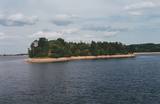 |
Каньон Даугавы от Плявиняс до Кокнесе до затопления был одним из лучших и красивейших форм Балтийского рельефа, а Олинькалнс - одним из крупнейших городищ в Латвии, 20-метровая скала (скала Андрея) которого была частью каньона Даугавы. До затопления у Олинькална на Даугаве был большой порог, что затрудняло работу сплавщиков. В наши дни Олинькалнс - это маленький остров в водохранилище Плявиньской ГЭС (зная это, его можно заметить с шоссе Рига – Даугавпилс (А6) напротив Стукмани), отделенный от берега речным рукавом шириной 0,3 км, под которым на дне покоится Иловая низина. На острове сохранился небольшой вал городища, остатки эстрады и обнажение доломита высотой в несколько метров – остатки скалы Андрея. Считается, что на Олинькалне в 13 веке находился замок Аленес. У Даугавы напротив Олинькална установлен камень, который в 1989 году установили латвийские альпинисты. |
|
 |
This restricted area protects the highest hillock in the Alūksne highlands – Dēliņkalns Hill – as well as the biotopes on its hillsides. The local landscape is also protected. Downhill ski trails are on the mountain, and its southern side offers lovely views.
|
|
 |
Eine der eindrucksvollen Reliefgestaltungen im Baltikum. Bei Sigulda erreicht das Urstromtal eine maximale Tiefe von 85 m ( Breite ung. 1 km). Schöne Sandsteinaufschlüsse aus dem Devon ist ein Anziehungspunkt. |
|
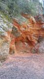 |
Sarkanās klintis savu vārdu ieguvušas pateicoties sarkanajiem iežiem. Tieši sarkanā ir mīlestības krāsa, tāpēc sarkanās klintis ir romatiska pastaigas vieta mīlniekiem. Smilšakmens klintīs redzamas plaisas, kas sašķeļ sarkanīgos iežus, radot neparastu dabas mākslas darbu. To virsma ir diezgan izrobota, kas veido klintīs nelielas alas un nišas. Sarkanajās klintīs ir arī daudz dažādu avotiņu. Pazīstamākais no tiem ir Rūcamavots. Tam ir šāds nosaukums, jo tas, nākot ārā no zemes, izdod nelielu rūkoņu. |
|
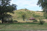 |
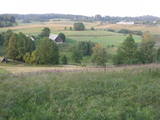
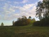
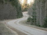
Ap 0,5 km ziemeļaustrumos no Stukmaņu muižas – Daugavas ielejas labajā krastā atrodas Vīna kalns – sens pilskalns. Tajā atrodas izpostītie Stukmaņu muižas īpašnieku kapi. Mazliet tālāk redzams klajš upes ielejas nogāzes posms, kurā savulaik darbojās slēpošanas trase. |
|
 |
Городище Спринги pасположено недалеко от города Резекне и
вызывает интерес своеобразной формой. Археологический
памятник местного значения.
|
|
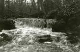 |
Here we find a set of canyon-type gullies among layers of dolomite. There are impressive outcrops and small waterfalls in the little river’s bed.
|
|
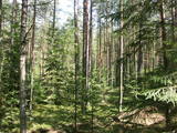 |
Ap 25 km gara un līdz 1,5 m plata vaļņveida reljefa forma Adzeles pacēluma dienvidu malā, kas apaugusi ar skujkoku mežu. Latvijā reti biotopi un nozīmīga daudzu aizsargājamu augu un dzīvnieku sugu dzīves vieta. Numerenes valni var ļoti labi "izjust", braucot pa Kārsavas - Tilžas ceļu. Dabas parkā atrodas slēpošanas kalns "Nūmerene".
|
|
 |
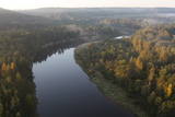
Городище Иденя расположено на северо-западном склоне озера
Лубана. С него открывается прекрасный вид на озеро и
болотистую местность вокруг озера. Заселено в 11 веке.
|
|
 |
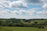
This is one of the most impressive and extensive natural structures of its kind in Latvia in terms of appearance and landscape. The ice age left behind this wall-like terrain, which is up to 27 metres high and at the top of which the Rīga-Ērgļi road has been built. The Great Kangari hills offer a view of the Great Kangars lake and the Great Kangari swamps and ponds. The Ķoderi castle hill, also known as the “Big Man’s Bed” is found here. The restricted area was established to protect the structure and its related biotopes and plants.
|
|
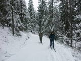 |
The nature park near the town of Ogre is a popular place for leisure, hiking and, in the winter, cross-country skiing. Most of the park is covered with coniferous trees that are on a long and comparatively narrow line of hillocks with steep sides – another element of nature left behind in Latvia by the Ice Age. Many different plants can be found here. The Jaunogres castle hill is one of the most distinct hillocks in the area. |
|
 |
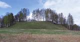
Sens pilskalns Abavas kreisā senkrasta nogāzē. Pēc sena nostāsta zviedru karavīri ar savām cepurēm to sabēruši virs sava ģenerāļa kapa. Tagad Zviedru cepures apkārtnē ziemā var braukt pa kalnu slēpošanas trasēm, bet vasarā – ar rodeļiem.
|
|
 |
This structure is smaller than the Great Kangari hills – approximately 10 kilometres long and 16 metres high. This structure is near the Buļļi swamp, and the restricted area is meant to protect the structure, the swamp and the various forest types and rare plants that are in the area.
|
|

