
| Нo | Название | Описание |
|---|---|---|
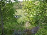 |
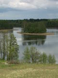
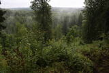
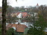
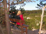
The viewing area is near the top of the Vilce castle hill, with a view of the Rukūze River valley, Zaķi meadow, and surrounding forests. This is an unusual landscape for the region of Zemgale. The Vilce baronial estate is nearby.
|
|
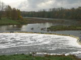 |
The recently renovated old brick bridge and the viewing area that is on the left bank of the Venta beyond the castle guard’s hut offers a lovely view of the widest and most impressive waterfall in Latvia – the Venta falls. It is worth visiting during the spring floods, when fish are migrating.
|
|
 |
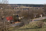
Gar Grobiņas ūdenskrātuvi (Ālandes labais krasts) izveidota mūsdienīga un labiekārtota pastaigu un atpūtas vieta - promenāde, uz kuras izvietotas plāksnes ar Zentas Mauriņas un Jāņa Raiņa citātiem. No promenādes paveras labi skatu punkti uz Skābaržkalnu un Grobiņas pilsdrupām. Grobiņas ūdenskrātuves sašaurinājumā pāri Ālandei ved neliels tiltiņš, kas ir bijušā Liepājas – Aizputes šaursliežu dzelzceļa tilta ferma. |
|
 |
Один из популярнейших туристическихобъектов Латгалии.С вершины возвышенности (247 м н.у.м., около 60 м над ближайшими окрестностями) приоткрывается один из красивейших видов Латгалии на находящееся в двух километрах озеро Разна. На Маконькалнсе находится построенный в XIII веке и практически неприступный замок Ливонского ордена Фолкенберг – одно из первых укреплений Латгалии, от которого до наших дней сохранились только фрагменты стен . У подножья Маконькалнса открыта памятная доска, вещающая о посещении Латгалии президентом Первой Латвийской Республики Карлисом Улманисом в 1938 году. |
|
 |
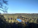
In Vecslabada, there is a peninsula among Lake Dziļezers, Lake Audzeļi, and Lake Istra. From the highest point on the peninsula, you will see a truly unusual view of the land of the blue lakes – lake islands, as well as the village of Vecslabada with its church towers. The Lake Istra nature reserve is nearby.
|
|
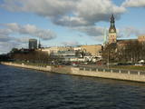 |
The classical skyline of Old Rīga can be enjoyed from several locations – Mūkusalas Street, between the railroad bridge and the stone bridge, from the stone bridge, from the A-B dam, from the grounds of the central office of the Swedbank bank, from the Vanšu bridge, and from the Ballast Dam at Ķīpsala. You can hike or bike from location to location. During the summer, little ships cruise up and down the Daugava to offer different views.
|
|
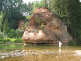 |
This is one of the most beautiful and popular tourism locations in Vidzeme. The cliff is 45 metres high, and the height of the lovely open-faced portion is around 20 metres high. You can look at the wide and deep Amata River valley and its forested banks.
|
|
 |
Molu (sākotnēji – pāļu rindas ar akmeņu krāvumiem) izbūve pie Sakas ietekas jūrā tika uzsākta 1878. gadā, lai nodrošinātu ostas darbību. 1929. gadā notiek molu pārbūve, pagarinot tos ar masīviem betona blokiem. Pēdējā rekonstrukcija notika 2010. gadā, pārveidojot molus par ērtu pastaigu un makšķerēšanas vietu, no kuras var vērot arī saulrietu. |
|
 |
At the highest point of Krievkalni (149 metres above sea level), there is a good location for relaxation which offers an impressive view toward the East.
|
|
 |
We recommend that you walk through the town of Kandava not only to enjoy the charm of a small town, but also to find fantastic viewing locations where you can see the town and the shores of the ancient Abava River valley from the Kurši (Ancestor) castle hill, Lielā Street, the Bruņinieki castle hill and Zīļu Street (School Hill), as well as from the area of the Ozolāji open-air stage.
|
|
 |
Latvia’s highest hill is the second highest in the Baltic States, but alas, it has only a wrecked viewing tower, so you’ll have to look for the best views on your own. You’ll find some around the tower and the ski trails, particularly Large and Small Golgotha. It is worth hiking the Gaiziņkalns nature trail.
|
|
 |
This is a view worth a journey from a distance. This is an impressive terrain for Latvia, and here you will see as far as the Hanja highlands of Estonia, where the Great Munameģis Hill – the highest surface in the Baltic States – can be found.
|
|
 |
The town of Talsi is known as the “town of the nine hillocks,” and it is worth touring the location on foot. You’ll find the best views from the Talsi castle hill (views of Lake Talsi and Ķēniņkalns Hill), Sauleskalns (Lake Talsi, the castle hill, Ķēniņkalns Hill), and the hiking trails of Ķēniņkalns (Lake Talsi, the castle hill, the historical town centre).
|
|
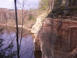 |
The viewing area on the Ērgļi (Ērģeles) cliffs offers an impressive view of Latvia’s most monolith sandstone cliffs (up to 22 metres high) – this is the highest location in the Gauja River valley. Please be very careful and don’t go anywhere near the edge of the cliff!
|
|
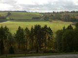 |
As you travel from Kandava to Sabile, you will find a parking lot on the right side of the road. From there, there are steps to a viewing area on the highest hill in the Abava Ancient River Valley – Greiļi Hill. This offers a wonderful view of the ancient river valley and the local mosaic of meadows and forests. The landscape is enriched by the Imula and Amula valleys that are on the other side of the ancient river valley.
|
|
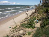 |
Начинается в нескольких километрах к северу от Павилосты и заканчивается недалеко до Ошвалки, протяженностью > 30 км. Его внушительные и необыкновенные формы просматриваются на участке Странте - Улмале, но и открывающиеся в окрестностях Юркалне (благоустроенные места для подхода, лестницы, автостоянки) виды (высота до 16 м) оставляют незабываемое впечатление! Отвесный берег рекомендуется наблюдать (смотреть, фотографировать) после сильных бурь, потому что во второй половине лета его обнажения (главным образом, песчаник, глина) выглядят менее выразительными из-за оползней и покрывающей растительности. Предыдущее название Юркалне – Феликсберг означало Счастливая гора. Теперешнее название это место получило в 1925 году. |
|
 |
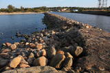
Daugavas aizsargdambju būvniecību Jēkabpilī uzsāka pēc 1981. gada lielajiem paliem, kad ūdens līmenis pārsniedza kritisko - 6,3 m atzīmi un pakāpās līdz rādījumam „8,7 metri”. Šo plūdu laikā puse pilsētas klāja Daugavas ūdeņi. 2011. gada vasarā notika plašāki dambja atjaunošanas un labiekārtošanas darbi. Pie tā uzstādīja laternas, soliņus, izveidoja pastaigu promenādi un piemiņas zīmi Daugavas kreisajā krastā, kas parāda maksimālo plūdu līmeni. Uz aizsargdambja Daugavas labajā krastā ir izvietoti informatīvie stendi, kur var uzzināt daudz interesantus faktus par pilsētas vēsturi. Dambji ir piemērota vieta, kur fotografēt vai gleznot pilsētas ainavas. |
|
 |
One of the highest dunes in Latvia, located between Bernāti and Jūrmalciems villages. It is 37m high and offers a magnificent view of the sea and natural pine forests. The highest dunes in Latvia stand to the South of Jūrmalciems village: the Pūsēnu hill, the Ķupu hill, the Mietragkalns or Tiesas hill, the Pāļu hill, the Garais hill, the Ātrais hill, the Lāvas hill. The Pūsēnu dune is the highest of these dunes which are all called hills by the local people. The Pūsēnu hill developed between 1785 to 1835 when shifting sand became extremely dangerous. Several homesteads were buried in sand, among them „Pūsēni”, where a forester’s family lived. The family is said to have moved to Bārta. The dune was named after the buried homestead. Jēkabs Janševskis, a Latvian writer, wrote in his book „Nīca”: “In olden times, large pine trees were growing in the dunes on the coast of Nīca and they stood steady and firm. But i Swedish times (around 1650), the Swedes built a large kiln for charcoal and tar. Pine wood and stumps provided an excellent material for this. Once a big fire rose, and the charcoal kiln burned down as well as the whole pine forest. The remaining stumps and bare trunks in the vast burnout could not hold the storm-driven sand; it flew further and further burying not only the burned-out forest, but also the nearest fields. In wintertime, when the vast, low marshy grasslands were covered with ice, jets of sand drifted further over its surface, and soon most of the grasslands and large meadows turned into sandy heath-land and dunes.” To reconstruct Liepāja, severely damaged during WWII, a silicate brick factory was built in the town. The main raw material was white sand and it was taken from the Bernātu forest. In the 1960-ies they started to dig off the Green Dune and the White Dune, later also the Pūsēnu hill. The excavators used to work day and night, in three shifts. The work stopped at around 1980, as there was no more sand suitable for production of brick. A trail is set up to facilitate walking in the Pūsēnu Dune in the Bernātu Nature Park. |
|
 |
On the left bank of the Gauja River, opposite the Piķene cliff is the mighty Beite cliff which is split by a deep ravine. On the left side there is Ķeizarskats (Emperor's View), which is approximately 67 metres above the level of the Gauja and offers a fine view of Krimulda and the Turaida Castle. The viewing place was installed in 1862, when Russian Tsar Alexander II visited Sigulda. On the right side of the ravine is the mighty wooden Ķeizarkrēsls (Emperor's Chair). To get there, you have to cross the ravine (there are wooden stairs and a forest trail). You can go around it on Laurenču, Kalna and Gulbju streets. |
|
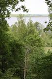 |
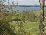
This is not a well known castle hill, but it offers one of the most unusual views of Lake Lielezers of Augstroze. There are ruins on the castle hill, and a short hiking trail has been installed to look at them. This is part of the ZBR.
|
|


