
| Нo | Название | Описание |
|---|---|---|
 |
Ирбский пролив - очень важная территория в период миграции птиц. Наиболее встречаемые охраняемые породы птиц - темная утка, черная утка, морянка, малая чайка, краснозобая и чернозобая гагара, а также чистик обыкновенный. Территория находится напротив Дундагского и Вентспилсского края, занимает площадь в 172 412 га.
|
|
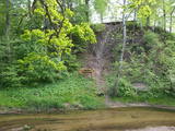 |
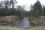
The Vilce Nature Park is small in size and exists alongside the deep valleys of the Vilce River and its tributaries. Biotopes include visible sandstone cliffs, rapids on the rivers, forests typical of such areas, and the plants and animals that are found therein. The well-appointed Vilce castle hill is next to the Zaķu meadow, which is a nicely appointed and popular place for recreation. |
|
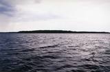 |
This is Latvia’s oldest nature reserve and, indeed, the country’s oldest protected natural territory. Moricsala is an island in Lake Usma, which is the fifth largest lake in Latvia. The reserve was established in 1912 at the initiative of a group of nature students from Rīga. They wished to protect the deciduous forest of oak trees on the island, along with the local flora and fauna. The nature reserve also includes the Lielalksnīte island. Visits to the reserve, however, are strictly prohibited. |
|
 |
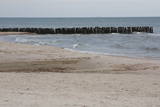
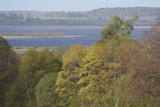
This is a segment of the shore of the Bay of Rīga that is around 40 km long and features the valleys of three major rivers – the Lielupe, Daugava and Gauja river. There are dune formations, biotopes, seashore meadows and forested seashore dunes which are an important recreational resource. |
|
 |
The main goal of the Vestiena protected landscape area is to protect the landscape values in the Vidzeme highlands. The protected area is in the middle of the Vidzeme highlands with the highest and most prominent relief, including Gaiziņkalns, the highest spot in the country. The many lakes found in the area - Viešūrs, Talejas, Kāls, Pulgosnis and others – not only add to the variety of the landscape, but also offer tourism and recreation options. The Vestiena protected landscape area encloses several other especially protected/Natura2000 sites – the Gaiziņkalna nature park, the island of the lake Kāla, the lake Ilziņa restricted natural area. Among the most interesting tourist attractions are the Vestiena estate, the Piekūnu wandering trails, the Gaiziņkalna nature trail. The area is rich in landscapes, however, there are no viewing spots or towers installed to observe the landscape. On the top of the Gaiziņkalns, the Latvia’s highest spot, there still stands the wreck of the former viewing tower.
|
|
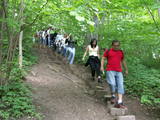 |
Место, где можно отправиться на короткие и продолжительные прогулки. Здесь создана «Тропа Спридитиса» (с деревянными скульптурами героев сказки Анны Бригадере), протяженностью 1,6 км, «Учебная тропа лесных пейзажей», протяженностью 3,8 км и 8-ми км (в одном направлении) «Тропа пейзажей Аугшземе». Тропы расположены в субгляциальной ложбине, сформировавшейся от таяния ледника, где друг за другом разместились соединенные протоками несколько озерков и болотцев. В целях охраны пейзажей и других ценностей создан природный заповедник. В начале троп (недалеко от Пилскалне) стоит 30-метровый Мелнайскалнс (городище Рамава).
|
|
 |
Nature restricted area includes eastern side of the lake with Lanupe River and North-east and South-east coastal areas. Restricted area has been established for protection of birds and floodplain meadows of the lake. To see the nature restricted area visitors do not have to enter it. There are great view points with wind generators of Grobina on the background from the road Vecpils – Rava – Aistere. Coastal areas which are not included in the restricted area are perfectly suitable for bird watching. There is located the smallest city by its population in Latvia to the South from the lake.
|
|
 |
Слитерский национальный парк (как заповедник основан в 1923 г., как национальный парк 2000 г.) не без основания называют музеем под открытым небом предшествующей стадии развития Балтийского моря. Современными «живыми» свидетелями тех геологических событий являются Слитерские Голубые холмы - крутые, высотой до 20 – 30 м, образовавшиеся со времен Балтийского ледового озера (стадия Балтийского моря до 10 000 лет назад), холмы Стиебру – древний берег Анцилового озера (8 – 9 тысяч лет тому назад), наибольший в Европе по площади ландшафт валообразных дюн (кангари) и заболоченных междюновых впадин (виги), которые являются образованиями времен Литоринского озера (4 – 7 тысяч лет тому назад). Мягкий климат Северного Курземе служит причиной тому, что здесь наблюдается многообразие пород растений (около 860 пород) и встречается очень много редких для Латвии растений (напр., тис обыкновенный и плющ балтийский). Своего рода заслуга в сохранении здешних природных богатств принадлежит и советскому военному режиму, существовавшему когда-то на морском побережье, и из-за которого на протяжении полувека побережье оставалось почти нетронутым с точки зрения посещения и строительства. Свидетелями того времени остаются покинутые базы и разные военные объекты армии СССР. В Слитерском национальном парке находится один из популярнейших объектов туризма Латвии - Колкский мыс, который в течение года посещают более 50 000 путешествующих, а во время весенней миграции через мыс в течение часа проносятся десятки тысяч птиц. На участке берега Балтийского моря – т.е. на Либиешском берегу от Колки до Сикрага и Овиши сохранились рыбацкие поселки ливов (одна из малочисленных народностей мира) и прочие свидетельства их культуры. К услугам туристов четыре природных тропы, веломаршруты, наблюдательная вышка, открыт для посещения Шлитерский маяк.
|
|
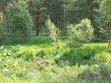 |
The word grīnis in Latvian refers to a very unusual type of forest – pine trees growing on sandy soil. There are two types of this environment – the heather type and the grass type. This is the result of long-lasting interaction between nature and humankind, and such sites are found in just a few places along the shores of the Baltic Sea in Latvia. A very rare plant which grows in the area – cross-leaved heath – was the main reason why a nature reserve was established here in 1936. An abandoned former rail line between Ventspils and Liepāja crosses the reserve from the North to the South. Visits to the reserve are strictly prohibited. |
|
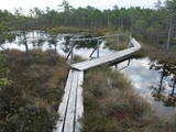 |
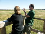
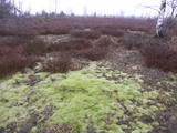
The Teiči Nature Reserve was established in 1982 and is one of the largest areas of moss swamps in the Baltic region. It consists of the Teiči and the Pelečāre swamps, with a variety of plants and animals, as well as adjacent territories which are under protection. The Teiči swamp is the largest nesting ground for a number of bird species, including the common crane, the whimbrel, the golden plover and the wood sandpiper. During migratory seasons, thousands of geese of various kinds are found in the area. The reserve can be toured only in the company of a guide from reserve headquarters, and one must apply in advance for such a tour. Visitors will see the pathway of footbridges on Lake Silda, as well as Siksala island, which offers a magnificent view of Latvian swampland from a viewing tower. |
|
 |
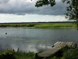
The most important aspects of this park are a shallow lagoon-type lake – Lake Pape, with its flood land meadows, the shore of the Baltic Sea, the Nida swamp, and the more than 270 different types of birds that have been spotted here. The oldest bird ringing station in Latvia (est. 1966) is found between Lake Pape and the Baltic Sea. Birds and bats are caught and ringed there. Lake Pape is the first place in Latvia where so-called “wild” horses (the “Konik” breed) were released with the aim of managing the flood land meadows.
|
|
 |
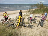
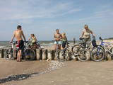
The key treasure in this park is that it has a lake that is one of the most intensive sites for birdwatchers in all of Latvia. It also features outstanding flora and the shallow waters of the Bay of Rīga. Recommended: Hike along the seashore from Mērsrags to Engure (20 km). See wild domestic animals (horses and cows) on the eastern shore of Lake Engure. There’s a bird-watching tower on the NW shore of the lake (approach from Kūļciems, where you can see domestic animals adapted to life in the wild, including the Blue Cows of Latvia). A bird-watching tower can be found at a place called Jomiņa near Mērsrags, where the seashore meadow is an uncommon biotope
|
|
 |
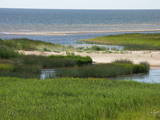
Западное побережье Рижского залива – важное место пристанища и питания большого количества мигрирующих пород птиц на протяжении года. Наиболее встречаемые виды птиц - краснозобая и чернозобая гагара, юрмальская большая утка, морянка, темная утка и малая чайка. Территория находится напротив Дундагского, Ройского и Энгурского края, а также города Юрмалы, площадь – 132 173 га. Территория включает морскую часть природного парка «Энгуре» и Кемерского национального парка.
|
|
 |
Baltijas mērogā unikāls dabas un cilvēkizmantots apvidus, kas veidojies kādreiz - padomju, mūsdienās - Latvijas Nacionālo bruņoto spēku pārvaldītā armijas poligona teritorijā. Poligona lielāko daļu aizņem smilšains vai ar zemiem lakstaugiem un krūmāju apaudzis kāpu masīvs ar atsevišķiem lielākiem kāpu vaļņiem. Rudens laikā šeit lielās platībās zied virši. Unikālā virsāju un aprimušo kāpu ainava un daudzu sugu dzīves vieta bija daži no iemesliem, kādēļ šai militārai teritorijai ir piešķirts arī aizsargājamas dabas teritorijas statuss. Jāatgādina, ka poligona apmeklējumi privātpersonām bez iepriekšēja saskaņojuma ir aizliegti!
|
|
 |
This is a large set of coastal meadows, ancient rivers and areas of reeds. It is found at a location where the Daugava River used to flow – between Vecmīlgrāvis and Vecāķi. There are inland dune meadows here, complete with the very rare silver grass. Vecdaugava is an important location for nesting birds and several uncommon plant species. On the southern end of the Vecdaugava peninsula, at a place called Skanstnieki, one can find remnants of medieval Swedish fortifications. The Vecdaugava Regional Research and Fishing Museum is here, as well.
|
|
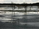 |
This is an open territory which is 3.5 km long and 2 km wide. It is located on the left bank of the Lielupe River between the village of Pavasari and the Odiņi homestead. The polder was established during the Soviet era to obtain farmland, and back then it was used very intensively. Today, it is slowly becoming overgrown, and despite this, this is one of the most important locations in Europe for corn-crakes. A gravel road crosses the polder from the North to the South, and this is an excellent place to hear the songs of the corn-crake. |
|
 |
This territory protects the shore of the onetime Baltic lake of ice, which most significant part stretches for 10 kilometres on the eastern side of the Grobiņa-Ventspils highway from Kapsēde till Vērgale bus stop. From the top of this ancient shoreline there is a lovely view of the Piejūra lowlands, but no specific viewing areas or information stands have been installed. There are protected species and habitats in the territory. |
|
 |
Айнажи – Салацгрива – важная территория для охраны рифов. Расположена напротив Салацгривского края, ее площадь составляет 7239 га.
|
|
 |
Nature restricted area is located to the South from former railroad Ventspils-Liepaja and includes approximately 6 km of Uzava River (and the old drainage system). The territory was used for agriculture during Soviet time, now it starts overgrow by scrubs. The protected nature values – rare bird species, including corncrakes, variety of grassland habitats and plant species. Territory is not useable for tourism activities. There is a possibility to get good insight into the North part of restricted area from the road Alsunga – Berzkalns where information stand is located.
|
|
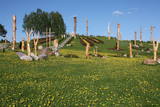 |
Atrodas nepilnus 2 km austrumos no Aglonas, Aglonas – Dagdas ceļa malā. Tā ieceres autors ir Ēriks Delpers, kurš 2006. g. uzsāka vietas labiekārtošanu, izveidojot brīvdabas skulptūru dārzu un stādījumus. Kristus Karaļa kalns šobrīd atrodas izveides procesā, taču neskatoties uz to – objekts, ko ir vērts redzēt! |
|
