
| No | Name | Description |
|---|---|---|
 |
This is an enormously important territory for migrating birds. The most commonly spotted protected species of birds are the velvet scoter, the black scoter, the long-tailed duck, the little gull, the red-throated and black-throated loon, and the black guillemot. The territory is opposite the Dundaga and Ventspils administrative districts, and it covers 172,412 hectares.
|
|
 |
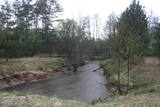
The Vilce Nature Park is small in size and exists alongside the deep valleys of the Vilce River and its tributaries. Biotopes include visible sandstone cliffs, rapids on the rivers, forests typical of such areas, and the plants and animals that are found therein. The well-appointed Vilce castle hill is next to the Zaķu meadow, which is a nicely appointed and popular place for recreation. |
|
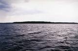 |
This is Latvia’s oldest nature reserve and, indeed, the country’s oldest protected natural territory. Moricsala is an island in Lake Usma, which is the fifth largest lake in Latvia. The reserve was established in 1912 at the initiative of a group of nature students from Rīga. They wished to protect the deciduous forest of oak trees on the island, along with the local flora and fauna. The nature reserve also includes the Lielalksnīte island. Visits to the reserve, however, are strictly prohibited. |
|
 |
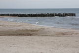
This is a segment of the shore of the Bay of Rīga that is around 40 km long and features the valleys of three major rivers – the Lielupe, Daugava and Gauja river. There are dune formations, biotopes, seashore meadows and forested seashore dunes which are an important recreational resource. |
|
 |
The main goal of the Vestiena protected landscape area is to protect the landscape values in the Vidzeme highlands. The protected area is in the middle of the Vidzeme highlands with the highest and most prominent relief, including Gaiziņkalns, the highest spot in the country. The many lakes found in the area - Viešūrs, Talejas, Kāls, Pulgosnis and others – not only add to the variety of the landscape, but also offer tourism and recreation options. The Vestiena protected landscape area encloses several other especially protected/Natura2000 sites – the Gaiziņkalna nature park, the island of the lake Kāla, the lake Ilziņa restricted natural area. Among the most interesting tourist attractions are the Vestiena estate, the Piekūnu wandering trails, the Gaiziņkalna nature trail. The area is rich in landscapes, however, there are no viewing spots or towers installed to observe the landscape. On the top of the Gaiziņkalns, the Latvia’s highest spot, there still stands the wreck of the former viewing tower.
|
|
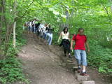 |
The Little Sigulda of Pilskalne is a place for longer or shorter hikes. Here you will find a number of trails – the Sprīdītis trail (1.6 km, featuring wooden sculptures of characters from fairy tales by Anna Brigadere), the Forest landscape educational trail (3.8 km), and the Highland landscape trail (8 km in each direction). The trails are in a sub-glacial depression with a number of little lakes and swamps that are connected by streams. This is a restricted environmental area aimed at protecting the landscape and its treasures. At the beginning of the trails (near Pilskalne) there is the Melnaiskalns (Rāmavas) castle hill, which is around 30 m high. |
|
 |
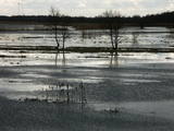
Nature restricted area includes eastern side of the lake with Lanupe River and North-east and South-east coastal areas. Restricted area has been established for protection of birds and floodplain meadows of the lake. To see the nature restricted area visitors do not have to enter it. There are great view points with wind generators of Grobina on the background from the road Vecpils – Rava – Aistere. Coastal areas which are not included in the restricted area are perfectly suitable for bird watching. There is located the smallest city by its population in Latvia to the South from the lake.
|
|
 |
The Slītere National Park (established in 2000) is known, with good reason, as an open-air museum which shows the historical development of the Baltic Sea. Nowadays evidence of geological events is seen in the Blue Hills of Slītere, which stand 20 to 30 metres high above what was the shore of the Baltic lake of ice 10,000 years ago. The Stiebri hills were former 8,000 or 9,000 years ago, while the Littorina Sea formed Europe’s largest set of dune ramparts and damp hollows between those ramparts. This occurred between 4,000 and 7,000 years ago. The gentle climate of Northern Kurzeme is the reason why so many rare plants are found in the park – some 860 in all including Common Yew (Taxus baccata) and Baltic Ivy (Hedera helix var. baltica). Of certain value in the preservation of these treasures was the Soviet military machine, which has left behind army bases and other military objects in the area. The presence of the military meant that the area of what is now the Slītere National Park remained largely undisturbed for 50 years. The park includes one of the most popular tourist destinations in Latvia – the Cape of Kolka, which is visited by more than 50,000 travellers each year. During the spring migration of birds, more than 60,000 birds cross the cape each hour. Along the shore of the Baltic Sea is the so-called Livonian coast, which stretches from Kolka to Sīkrags and Ovīši. Fishing villages and other cultural objects established by the world’s smallest ethnic minority, the Livonians, can be found here. Tourists will enjoy interesting four nature trails, bicycling routes, viewing tower, etc. The visitors centre is located at the Slītere lighthouse. Administration of National park is organising environmental education events on regular basis open to everyone. |
|
 |
The word grīnis in Latvian refers to a very unusual type of forest – pine trees growing on sandy soil. There are two types of this environment – the heather type and the grass type. This is the result of long-lasting interaction between nature and humankind, and such sites are found in just a few places along the shores of the Baltic Sea in Latvia. A very rare plant which grows in the area – cross-leaved heath – was the main reason why a nature reserve was established here in 1936. An abandoned former rail line between Ventspils and Liepāja crosses the reserve from the North to the South. Visits to the reserve are strictly prohibited. |
|
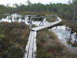 |
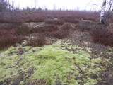
The Teiči Nature Reserve was established in 1982 and is one of the largest areas of moss swamps in the Baltic region. It consists of the Teiči and the Pelečāre swamps, with a variety of plants and animals, as well as adjacent territories which are under protection. The Teiči swamp is the largest nesting ground for a number of bird species, including the common crane, the whimbrel, the golden plover and the wood sandpiper. During migratory seasons, thousands of geese of various kinds are found in the area. The reserve can be toured only in the company of a guide from reserve headquarters, and one must apply in advance for such a tour. Visitors will see the pathway of footbridges on Lake Silda, as well as Siksala island, which offers a magnificent view of Latvian swampland from a viewing tower. |
|
 |
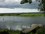
The most important aspects of this park are a shallow lagoon-type lake – Lake Pape, with its flood land meadows, the shore of the Baltic Sea, the Nida swamp, and the more than 270 different types of birds that have been spotted here. The oldest bird ringing station in Latvia (est. 1966) is found between Lake Pape and the Baltic Sea. Birds and bats are caught and ringed there. Lake Pape is the first place in Latvia where so-called “wild” horses (the “Konik” breed) were released with the aim of managing the flood land meadows.
|
|
 |
The key treasure in this park is that it has a lake that is one of the most intensive sites for birdwatchers in all of Latvia. It also features outstanding flora and the shallow waters of the Bay of Rīga. Recommended: Hike along the seashore from Mērsrags to Engure (20 km). See wild domestic animals (horses and cows) on the eastern shore of Lake Engure. There’s a bird-watching tower on the NW shore of the lake (approach from Kūļciems, where you can see domestic animals adapted to life in the wild, including the Blue Cows of Latvia). A bird-watching tower can be found at a place called Jomiņa near Mērsrags, where the seashore meadow is an uncommon biotope
|
|
 |
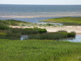
This is an area where migrating birds seek shelter and food all around the year. Seen most often here are the red-throated and black-throated loon, the common shelduck, the long-tailed duck, the velvet scoter and the little gull. The territory is also important for the protection of reefs. It lies opposite the Dundaga, Roja and Engure administrative districts, as well as the city of Jūrmala, and it covers 132,173 hectares of territory. The marine parts of the Engure Nature Park and the Ķemeri National Park are covered.
|
|
 |
Baltijas mērogā unikāls dabas un cilvēkizmantots apvidus, kas veidojies kādreiz - padomju, mūsdienās - Latvijas Nacionālo bruņoto spēku pārvaldītā armijas poligona teritorijā. Poligona lielāko daļu aizņem smilšains vai ar zemiem lakstaugiem un krūmāju apaudzis kāpu masīvs ar atsevišķiem lielākiem kāpu vaļņiem. Rudens laikā šeit lielās platībās zied virši. Unikālā virsāju un aprimušo kāpu ainava un daudzu sugu dzīves vieta bija daži no iemesliem, kādēļ šai militārai teritorijai ir piešķirts arī aizsargājamas dabas teritorijas statuss. Jāatgādina, ka poligona apmeklējumi privātpersonām bez iepriekšēja saskaņojuma ir aizliegti!
|
|
 |
This is a large set of coastal meadows, ancient rivers and areas of reeds. It is found at a location where the Daugava River used to flow – between Vecmīlgrāvis and Vecāķi. There are inland dune meadows here, complete with the very rare silver grass. Vecdaugava is an important location for nesting birds and several uncommon plant species. On the southern end of the Vecdaugava peninsula, at a place called Skanstnieki, one can find remnants of medieval Swedish fortifications. The Vecdaugava Regional Research and Fishing Museum is here, as well.
|
|
 |
This is an open territory which is 3.5 km long and 2 km wide. It is located on the left bank of the Lielupe River between the village of Pavasari and the Odiņi homestead. The polder was established during the Soviet era to obtain farmland, and back then it was used very intensively. Today, it is slowly becoming overgrown, and despite this, this is one of the most important locations in Europe for corn-crakes. A gravel road crosses the polder from the North to the South, and this is an excellent place to hear the songs of the corn-crake. |
|
 |
This territory protects the shore of the onetime Baltic lake of ice, which most significant part stretches for 10 kilometres on the eastern side of the Grobiņa-Ventspils highway from Kapsēde till Vērgale bus stop. From the top of this ancient shoreline there is a lovely view of the Piejūra lowlands, but no specific viewing areas or information stands have been installed. There are protected species and habitats in the territory. |
|
 |
This is another important territory for the protection of reefs, is also opposite the Salacgrīva Administrative District, and covers 7,239 hectares.
|
|
 |
Nature restricted area is located to the South from former railroad Ventspils-Liepaja and includes approximately 6 km of Uzava River (and the old drainage system). The territory was used for agriculture during Soviet time, now it starts overgrow by scrubs. The protected nature values – rare bird species, including corncrakes, variety of grassland habitats and plant species. Territory is not useable for tourism activities. There is a possibility to get good insight into the North part of restricted area from the road Alsunga – Berzkalns where information stand is located.
|
|
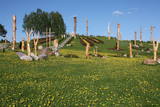 |
Atrodas nepilnus 2 km austrumos no Aglonas, Aglonas – Dagdas ceļa malā. Tā ieceres autors ir Ēriks Delpers, kurš 2006. g. uzsāka vietas labiekārtošanu, izveidojot brīvdabas skulptūru dārzu un stādījumus. Kristus Karaļa kalns šobrīd atrodas izveides procesā, taču neskatoties uz to – objekts, ko ir vērts redzēt! |
|
