
| No | Name | Description |
|---|---|---|
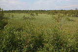 |
There is no need to enter the bog to see it, there are good views from the highway Ventspils – Riga (77 km, bus stop “Pagrieziens uz Elkskeni”). The main value of restricted area is chalky fen bog with brown bog-rush (greatest habitat finding in Latvia). Be careful when stopping on the highway – mind the traffic! A couple of kilometers towards Riga, on the right side of the highway, there is sign to Grizu Velna kresls ( Grizu Devil Chair) which is an attractive boulder (protected).
|
|
 |
Bārbeles sēravots tiek dēvēts par vienu no pirmajām kūrvietām Latvijā, proti, jau ap 1650. gadu hercoga Jēkaba valdīšanas laikā sēravota tuvumā uzbūvēta vannu māja, dēvēta par mazo ūdensdziednīcu, kuru vēlāk arī apmeklējuši visi Kurzemes-Zemgales hercogi. 1739. gadā Rīgas garnizona ārsts Benjamins Teofils Grofs uz Bārbeles sēravotu nosūtījs 10 ievainotus un smagi slimus karavīrus, kas sirguši ar dažādām kaitēm - pēc Bārbeles sēravota vannām karavīri atveseļojušies. Avota ūdeni izmantojuši gan apkārtējie zemnieki, gan muižnieki, gan augstmaņi no Jelgavas. Avotā slimnieki peldējušies, aptriepušies ar dūņām, no tā sagatavotas arī siltās vannas. Tāpat ūdens tika izmantots iekšķīgai lietošanai. Bārbeles sēravots dziedinājis ne tikai skorbutu, locītavu un krustu sāpes, artrītu, pietūkumu, bet arī venēriskās slimības-sifilisu, nervu kaites un daudzas citas slimības. 19. gs. avota ūdenī samazinājās sērūdeņraža koncentrācija. Neskatoties uz to, 20. gs. 20. gados šeit vēl aizvien darbojās vannu māja, tika uzbūvēts arī neliels vasarnīcu rajons, ierīkots deju laukums un parks, kūrorts tolaik tika plaši apmeklēts. Diemžēl, kūrorta noriets seko pēc Otrā Pasaules kara, kad to noposta un vairs neatjauno. Šobrīd par savulaik tik ļoti apmeklēto un nozīmīgo kūrvietu, dēvētu par pirmo kūrortu Latvijā, var tikai iztēloties. Atrodoties pie sēravota, tā laika liecības iezīmējas pēdējās vannu mājas ēkas pamatu drupās, stalti liecinieki arī koki – glabājot sevī savulaik pieredzēto. Sēravota apkārtnē ierīkota atpūtas vieta, informatīvs stends, kurā var aplūkot senākas fotogrāfijas un detalizētāk iepazīties ar kūrorta vēsturi. Tāpat ierīkota laipa, no kuras apmeklētāji var pasmelt avota ūdeni. |
|
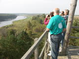 |
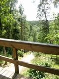
The old wooden tower at this site was torn down and replaced with the one that is there now. The restored tower offers one of the loveliest views in Eastern Latvia – one of the eight curves of the Daugava. This is the Rozališki curve. Here you will get a whole new sense of the Daugava River and its mighty valley in a place where the waters of a hydroelectric plant bubble away in our present day and age. It is claimed that the scene that is seen on the 10 lats note is based on the view which can be seen to the West from the tower. |
|
 |
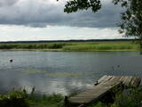
A restricted area with a set of artificial ponds to the South-west of Saldus. The ponds attract many different kinds of birds during nesting and migration season. The location has not been improved for tourist purposes, but it is still an interesting place for some bird-watching. The forests around the ponds are also home to many protected birds and species of bat. |
|
 |
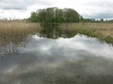
This is a large set of coastal meadows, ancient rivers and areas of reeds. It is found at a location where the Daugava River used to flow – between Vecmīlgrāvis and Vecāķi. There are inland dune meadows here, complete with the very rare silver grass. Vecdaugava is an important location for nesting birds and several uncommon plant species. On the southern end of the Vecdaugava peninsula, at a place called Skanstnieki, one can find remnants of medieval Swedish fortifications. The Vecdaugava Regional Research and Fishing Museum is here, as well.
|
|
 |
The German order built a stone castle here in 1242, and only a few fragments of it remain along with a vaulted cellar in which local wines can be tasted if you register in advance. The castle of the Duke of Courland was here later, but it was destroyed during the Great Northern War in 1701. Reconstruction of the park involved wooden pathways and bridges, information stands, a pergola and a fountain. There are 22 sculptures in the park that are the work of Līvija Razevska. |
|
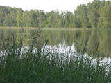 |
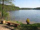
These two lakes, along with Lake Mazezers, Lake Auziņš, Lake Skuja and Lake Bruņķītis, are found in a sub-glacial depression with shores and hillsides that are home to various kinds of forest, including stands of broadband trees such as ash. These are protected habitats. Alongside the Priedītes homestead there is a well-appointed nature trail for visitors who wish to study Lake Dziļezers and its surroundings. A boating facility is on the north-eastern shore of the Lake.
|
|
 |
Vikmesti dēvē arī par Foreļstrautu, jo tā ir nozīmīga foreļu un taimiņu nārsta vieta. Gaujas labā krasta pieteka ir izveidojusi dziļu gravu ar stāvām nogāzēm, kuras lejtecē izveidojušies nelieli – ap 4 m augsti smilšakmens atsegumi. Gravas labajā (rietumu pusē) paceļas ar mežu apaugušais Vikmestes pilskalns. Gar Vikmestes upi izveidota taka, kuras sākumdaļa atrodas pie Siguldas – Turaidas ceļa, bet beigu daļa – pie Raganas – Turaidas ceļa (ap 3 km). |
|
 |
Dabas liegums veidots ezera, tā salu, ainavas, augu, putnu un sikspārņu aizsardzībai. Liegumu var apskatīt "no malas" - no ceļa, kas iet gar tā ziemeļu un ziemeļaustrumu robežu.
|
|
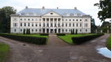 |
Work on the park began in end of 18th century, when it was a landscape park with trails for strolling and a system of pathways, benches and bridges. The 196-ha park is one of the largest estate parks in Latvia, and in dendrological terms it is one of the richest ones, with more than 200 varieties of trees and bushes, including 127 foreign ones. The park encircles the village of Kazdanga, including the Kazdanga Castle and the territory to its north, where you will find the burying grounds of the Manteuffel family. These were established at the very beginning of the 20th century, but the work was interrupted by World War I. The park features leisure areas and decorative elements. The castle was built around 1800 by the European-level architect Johann Gregor Berlitz after a design by architect Giacomo Quarenghi. The ensemble included a Cavalier House, a granary, a residential home, a stable, a bridge across the valley and other structures. An agricultural school was opened in the castle in 1924. Today it is the Kazdanga Museum, with the local Tourism Information Centre.. |
|
 |
The aim of this territory is to regulate the natural and cultural landscapes of the upper reaches of the Daugava River valley, where there is a great deal of biological diversity. Nature trails have been installed in the park, as have bicycle routes. The river is good for boating in this area, too. The Curves of the Daugava nature park is part of the territory (see “Nature Parks”). |
|
 |
The Neļķes cliffs are in Skaņākalns Park, and they offer the most beautiful view of the Salaka River valley, with its sandstone cliffs and peaceful river. There are good views from the “devil’s pulpit.” It’s worth visiting the Skaņamkalns Hill to check out the views from the famous echo cliff. This is part of the ZBR.
|
|
 |
The Krāču hills (Krāckalni) are a series of
wavy hillocks dating back to the Litorine Sea.
There is a lovely view of Lake Lilijas from here.
Opposite the lake, on the eastern side of the
road, are dolomite stairs which lead to a
monument dedicated to 90 Latvian riflemen who
lost their lives in battles in 1917 in the region.
|
|
 |
The tower is on the banks of the little Tērvete River, with a view of the river valley and surrounding forests. Good views of the Tērvete River valley are also available from the nearby Zviedru Hill and the Tērvete castle hill. Note: The viewing tower at the Tērvete Ancient History Museum is not open to visitors!
|
|
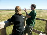 |
The viewing tower is in a seaside meadow near Mērsrags. It is an unusual type of biotope in Latvia and is located to the North of the Mērsrags port. The tower offers a good view of reed-filled meadows, areas where wild cattle have grazed, and an amazing wealth of different kinds of plants. |
|
 |
The Mežotne castle hill is on the left bank of the Lielupe River and opposite the Mežotne Castle. This was one of the largest Semigalian fortified castle hills during the 9th to the 13th century, and an ancient town alongside the hill covered 13 ha of land. The castle hill has been improved. A pontoon bridge across the Lielupe allows hikers and bikers to reach the castle (between May and October). Vīna Hill is approximately 500 m to the South of the castle hill, and a wooden pathway leads to it. |
|
 |
The tower is beyond the Oleri estate, in the small Oleri swamp, where at the end of a wooden footpath you can step upward a bit and learn about the landscape of a transitional swamp. This is part of the ZBR.
|
|
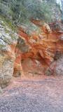 |
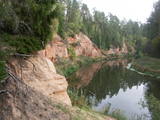
Sarkanās klintis savu vārdu ieguvušas pateicoties sarkanajiem iežiem. Tieši sarkanā ir mīlestības krāsa, tāpēc sarkanās klintis ir romatiska pastaigas vieta mīlniekiem. Smilšakmens klintīs redzamas plaisas, kas sašķeļ sarkanīgos iežus, radot neparastu dabas mākslas darbu. To virsma ir diezgan izrobota, kas veido klintīs nelielas alas un nišas. Sarkanajās klintīs ir arī daudz dažādu avotiņu. Pazīstamākais no tiem ir Rūcamavots. Tam ir šāds nosaukums, jo tas, nākot ārā no zemes, izdod nelielu rūkoņu. |
|
|
|
Atrodas pie tilta (Akadēmijas iela 1) pār Lielupi. 1574. g. pēc Kurzemes – Zemgales hercoga Gotharda Ketlera pavēles uzsāk jaunas baznīcas celtniecību. Dievnama tornis tapa laikā no 1686. g. – 1688. g., bet 1862. g. to paaugstināja līdz 80,5 m. Baznīca nodega padomju aviācijas uzlidojuma laikā 1944. g. 27. jūlijā. 1954. g. Padomju armijas sapieri uzspridzināja ēkas atliekas. 2009. g. sākās baznīcas torņa rekonstrukcija un šobrīd tajā izveidots izcils interaktīvais muzejs (īpaši draudzīgs bērniem) un stiklota skatu platforma. |
|
|
|
Atrodas Riekstusalas pussalas galā. No tā labi pārskatāma aizaugušā Kaņiera ezera ziemeļu un austrumu daļa. Izcila putnu vērošanas vieta. Pie torņa atrodas viena no retajām Latvijas kadiķu audzēm. Turpat meklējams Kaņiera ezera niedru laipas (uz pontoniem) sākums. |
|


