
| No | Name | Description |
|---|---|---|
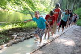 |
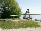
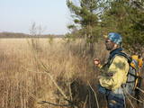
The first barefoot trail created in the Baltic States in the recreation complex "Valguma pasaule", which is located on the forested shores of Lake Valguma. When walking on the path, the feet "massage" sand, wood chips, clay, peat, gravel, cones and various other materials. |
|
 |
Atrodas Lubāna dienvidu krastā pie dambja un Īdeņas kanāla, no kura var aplūkot „tipiskas” mitrāju ainavas – niedrājus, aplūstošus krūmājus, mitras pļavas, aizaugušo ezeru. |
|
 |
Starpiņupīte is an artificial canal
between Lake Kaņieris and the Bay of
Rīga. It helps to regulate the water level in
the lake with a system of locks. This is a
fine place for birdwatching in the spring
and autumn. From the sea, the location
can be identified via the place where the
little river flows into the sea.
|
|
 |
It is rare type of lake in Latvia and there are only of few this type of lakes in Kurzeme region. The lake is characterized by high water limpidness (very attractive for tourists) and very rare plant species for Latvia. Nature park includes the lake, costal area and forest on the East from the lake, few smaller lakes and Sarlote Pond. There are several tourist accommodations located around the lake.
|
|
 |
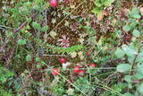
The most important aspect of the Sasaļi forest is the eutrophic Lake Sasalis, as well as the unusual Lake Melnezers. Also of importance are various types of forestland in the area. Lake Sasalis is a popular place for leisure and swimming.
|
|
 |
Atrodas pie Jēkabpils – Rēzeknes autoceļa (A 12), - autostāvlaukuma malā. No torņa redzama samērā plaša Teiču purva daļa ar atsevišķām salām (kokiem apauguši paaugstinājumi) augstā purva ainavā. Teiču purvam ir dabas rezervāta statuss, tādēļ apmeklējams ir tikai tornis. |
|
 |
The territory has been established for protection of the bog and its habitat species. It is not appropriate for visits. North-east part of the bog can be slightly seen from the road Neveja – Lapmezciems on winter season. Further on Cirste direction is located on of most impressive oak trees in Latvia – Rigzemju ozols.
|
|
 |
Meklējams Zirgu salas dienviddaļā – uz t.s. Golodova dambja. Tornis pieejams kājāmgājējiem un velobraucējiem. Automašīna jāatstāj pie Ezermalas ielas. No torņa redzams plašs skats uz daļēji aizaugušo Liepājas ezera ziemeļdaļu. Laba putnu vērošanas vieta. Ietilpst Liepājas ezera dabas lieguma teritorijā. |
|
 |
Relatīvi grūti pieejama un cilvēka mazskarta teritorija kūdrā izstrādātajā Cenas tīreļa ziemeļaustrumu daļā, kur saglabājušies augstā purva biotopi ar purva ezeriem, kas kopumā veido nozīmīgu vietu ligzdojošām un migrējošām zosveidīgo, tārtiņveidīgo u.c. putnu sugām. Teritorija nav piemērota (un nav vēlams) tūrisma aktivitātēm.
|
|
 |
Dabas liegums veidots ainaviskā Kāla ezera trīs salu (Tolkas, Lielā Vestienas un Vistu sala) un to mežu biotopu aizsardzībai. Diemžēl, salu apmeklētāji (makšķernieki?) aiz sevis ir atstājuši ne tikai nelabiekārtotas apmetņu un ugunskuru vietas, bet arī atkritumus. Tā kā salu vērtību spēs novērtēt tikai zinošs speciālists, ieteicams dabas liegumu vērot no skaistajiem un pauguriem klātajiem Kāla ezera ziemeļu un austrumu krastiem. Teritorija atrodas Vestienas aizsargājamo ainavu apvidū.
|
|
 |
The Kaļķupe River valley was established as the Pilsupe River (formed by Kaļķupe River and Mazupe River) crossed the Blue hills of Šlītere to the South of Vīdale and Kaļķi. The distinct river valley has a branched network of gullies in which Devonian sandstone has been uncovered and can be seen in some locations. Puiškalns Hill (located at confluence of Kaļķupe River and Mazupe River), which was used as a castle hill and as a sacred location long in the past, is one of the most distinctive parts of the area. It is a popular tourist destination in the Talsi District. Hillside forests, various kinds of meadows and a wide range of plants are also of value in the local environment. |
|
 |
Viewing tower on pontoons, and there is a footpath to get to it. The tower offers a view of nearly all of Lake Sloka, all the way to Kauguri. Particularly visible is the northern part of the lake. There is also a sulphur spring. The site is good for bird-watching throughout the year, including the winter, because parts of the lake do not freeze over. |
|
 |
Meklējams pie Gulbjiem – Dvietes senlejas informācijas centra. No torņa labi pārskatāma ūdeņiem bagātos pavasaros pārplūstošā Dvietes paliene, dzīvei savvaļā pielāgoto mājlopu aploki un izlīkumotā Dvietes upīte. |
|
 |
From the Markova castle hill, which you will access from the local information trial, you will see a view of the Daugavsargi curve of the Daugava. Further along, you will reach the open shore of the Daugava to see one of the most unique landscapes of Latvia’s river valleys. The Slutišķi village of Old Believers and the mighty Slutišķi cliff will be in the background.
|
|
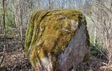 |
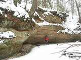
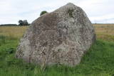
The Boulder of Labvārži is located in the Northern side of Adamova Nature Park, in the SW of Lake
Vizulītis (Labvārži). It is located 0,70 km from the Labvārži or Laboržu House. The boulder is 5.9m long and
4,0 m wide.
|
|
 |
No ģeogrāfiskā un kultūrvēsturiskā viedokļa interesanta teritorija Latgales augstienes Rāznavas paugurainē, kuras nozīmīgākie resursi ir dažāda veida biotopi, ainavas, reljefs un Šķaunes ezers. Istras pauguraines dabas parkā nav ar tūrismu saistīti labiekārtojumi, bet šo teritoriju var apskatīt arī „no malas”, braucot pa grantēto ceļu no Soboļinas uz Osinovku, kas iet līdztekus parka ziemeļu robežai (skats uz Šķaunes ezeru).
|
|
 |
This lime swamp of grasses is in an area among dunes which floods from time to time, and it is an important location for many protected plants. The swamp is easily surveyed from the forested dunes which are on the south-eastern side of the swamp. |
|
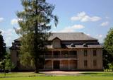 |
This estate is surrounded by an ancient and geometric landscape. During the latter half of the 19th century, it had a landscape style with various elements of geometry. The park covers 4.2 ha and has ancient linden, maple, elm, oak and other decorative bushes, with more than 20 types of plants that have turned into wood. |
|
 |
Atrodas 4,5 km ziemeļos no Rīgas – Daugavpils šosejas (A 6), klajā laukā (ap 3 m augsts, ainavisks). Viens no izcilākajiem Latvijas muldakmeņiem, tādēļ ir vērts izmest kādu loku. Akmens augšdaļā ir iekalts gandrīz 2 m garš un ~ 20 cm dziļš muldveida iedobums. Atrodamas ziņas, ka vēl 19. gs. vidū pie akmens ir ziedots ēdiens, monētas u.c. priekšmeti. Pie tā dedzināti ugunskuri un svinēti svētki. Teikas vēsta, ka velns muldā lējis ūdeni un gribējis mīcīt mīklu, kā arī parāvis zem akmens tuvējo māju saimnieku. |
|
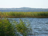 |
The eastern, southern and western shores of Lake Rāzna have roads which offer many lovely and unusual views of Latvia’s second largest lake and its surrounding landscape. Particularly lovely is the road between Foļvarkova and Vilkakrogs, which is part of the Rēzekne-Ezernieki road.
|
|


