
| Нo | Название | Описание |
|---|---|---|
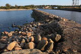 |
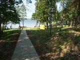
Molu (sākotnēji – pāļu rindas ar akmeņu krāvumiem) izbūve pie Sakas ietekas jūrā tika uzsākta 1878. gadā, lai nodrošinātu ostas darbību. 1929. gadā notiek molu pārbūve, pagarinot tos ar masīviem betona blokiem. Pēdējā rekonstrukcija notika 2010. gadā, pārveidojot molus par ērtu pastaigu un makšķerēšanas vietu, no kuras var vērot arī saulrietu. |
|
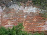 |
One of the most popular areas of uncovered sandstone in Latvia, known for its unusually smooth and sound-reflecting cliff wall (around 12m in height). Located on the right bank of the Salaca river, there is a place for tenting. A fun experiment is to stand in various closes opposite the cliff and to speak quietly. The echo will be heard either by the speaker or by people who are standing elsewhere. Located in the Salaca valley nature park and the Skaņaiskalns park.
|
|
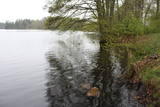 |
It is rare type of lake in Latvia and there are only of few this type of lakes in Kurzeme region. The lake is characterized by high water limpidness (very attractive for tourists) and very rare plant species for Latvia. Nature park includes the lake, costal area and forest on the East from the lake, few smaller lakes and Sarlote Pond. There are several tourist accommodations located around the lake.
|
|
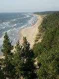 |
Construction on the lighthouse was initially completed in 1879. The structure suffered damage during both world wars and was restored several times. The structure is 19 metres high and stands 46.5 metres above the wavy sea. Here you will find one of the loveliest views of the shores of the Baltic Sea.
|
|
 |
There is a small and relatively hard to reach area on the western shore of Lake Būšnieks which has been restricted to protect swamp habitats and several protected plants. Boat base is on the northern shore of the lake offers boat rental. From the plank-way good sites of eutrophic part of Lake Būšnieks can be seen. A well-appointed recreational facility (not included in the restricted area) is on the opposite shore of the lake. |
|
 |
Восстановительные грязевые пруды
это место, где депонируются использованные
курортным и реабилитационным центром
"Яункемери" грязи.
|
|
 |
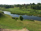
Nature restricted area includes eastern side of the lake with Lanupe River and North-east and South-east coastal areas. Restricted area has been established for protection of birds and floodplain meadows of the lake. To see the nature restricted area visitors do not have to enter it. There are great view points with wind generators of Grobina on the background from the road Vecpils – Rava – Aistere. Coastal areas which are not included in the restricted area are perfectly suitable for bird watching. There is located the smallest city by its population in Latvia to the South from the lake.
|
|
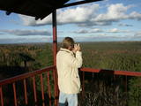 |
The viewing tower is in the southern part of the reserve, along the Ļaudona-Mārciena road and on the Madona-Trepe embankment. Here you can view a very wide territory all the way to the Vidzeme highlands, including Gaiziņkalns Hill if the weather is clear. At the foot of the tower you will see the lakes known as Small and Great Lake Plencis. |
|
 |
Амата является одной из самых быстроводных рек Латвии, поэтому каждую весну здесь собираются любители водного туризма – ценители спортивных мероприятий и любители острых ощущений! Вниз по течению, вдоль автомобильной дороги Рига – Вецлайцене, Амата впадает в глубокое русло, где ее среднее падение превышает 3 м/км, достигая даже 8 - 10 м/км. Русло Аматы изобилует обнажениями пород песчаника и доломита, которые называются утесами, самые знаменитые из них - это утес Визулю (здесь может образовываться красивый ледопад), обрыв Айнаву, утес Каубью, Дзилнас, Звартес и Лустузис. От Мелтури до моста Вецлаучу вдоль правого берега имеется маркировка (оранжевые точки на деревьях) т.н. Аматская геологическая тропа. У тропы есть три части: Мелтури – рыбное хозяйство Карлю, рыбное хозяйство Карлю – утес Звартес, утес Звартес – мост Вецлаучу. В поход по тропе можно отправиться в любое время года, за исключением – в зиму, когда глубокий снег. Самые впечатляющие виды открываются поздней осенью, когда нет листвы. |
|
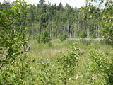 |
This swampy territory used to be part of a Littorena Sea lagoon, and it is a place where many rare and protected birds such as woodpeckers live and nest. Territory is hard to reach although some of the territory can be surveyed from the Tukums-Kolka road. Wet meadows is called "lankas" in Kurzeme region. |
|
 |
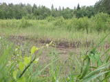
Болото Бажу – самое большое болото в Слитерском национальном парке –
зона строгого режима, нахождение в которой запрещено.
|
|
 |
Ap 9 km garā taka (vienā virzienā) sākas Skaņākalna dabas parkā (Mazsalacā) un beidzas pie Ramatas. Tā iepazīstina ar Salacas ielejas dabas parka nozīmīgākajām vērtībām – smilšakmens atsegumiem (Skaņaiskalns, Dauģēnu klintis u.c.), alām, nozīmīgu izmēru laukakmeņiem u.c. Taka marķēta. Tajā izvietoti informācijas stendi, norādes. Jāpadomā par loģistiku – kā nokļūt sākuma punktā. |
|
 |
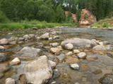
The Brasla River flows through a lovely valley that is approximately 300 m wide and up to 30 m deep. It is near the Inčukalns-Valka highway. The river has among the most beautiful rapids in the country, with mighty cliffs (the Brasla cliffs) that can be seen at nearly every curve in the river (except along the lowest reaches of the river). During the winter, various unusual frozen waterfalls can be seen in some of the cliffs, including the Krauļukalns cliff and the Jāņavārti cliff. On the left bank of the Brasla, opposite the Brasla fish farm, there are the Aņīte cliffs -- a series of sandstone cliffs that are 1 km long. The cliffs are between 2 and 35 m in height, and the sandstone cliffs are separated by ravines. On the right bank of the Brasla, there are major cliffs such as the Vāršavu cliff, the Kraukļukalns cliff, the Jāņavārti cliff, the Slūnu cliff, the Virtaka cliff and the Buļi cliff. How can you best learn about them? Boat down the river from the aforementioned highway or even from Straupe, which is further upstream. An alternative is hiking down the right bank of the river, though please take into account that the terrain is fairly extreme, and you are going to have to think about what to do when you arrive at the place where the Brasla River flows into the Gauja. |
|
|
|
Kartavkalnā, kur senāk atradusies seno zemgaļu apmetne, ir izveidota dabas taka ar soliņiem, piknika vietām. Šeit apskatāms arī Jaunpils Kartavu kalns un lapegļu aleja, kā arī iespējams aplūkot, kāda izskatās senlatviešu apmetne ar īstu guļbaļķu sētu.
|
|
 |
It is worth hiking this road where in crosses the Šlītere Blue Hills. This part of the road is approximately one kilometre long, and it goes down to the valley of the stream which crosses the hills. The place has been given a peculiar name – the Kušperlankgrāvis ravine (or the Zeltiņi ravine, as is claimed in other sources). If you're driving, be careful, because there is no bridge here, just a ford. During the early spring or the winter, you will appreciate the ravines and the impressive Blue Hills themselves. Impressive sandstone cliffs which are several metres high and have been vandalised by human hands are on both sides of the road. There is a small niche in one of the cliffs. To the right (East) from the road at the terrace of the Blue Hills is a side road which leads to the Mežlīdumi homestead. Please be gentle with the cliffs! |
|
 |
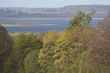
The Bauska Nature Park runs for several dozen kilometres along the Lielupe River and its tributaries – the Mūsa and the Mēmele. This is a protected territory. The shores of these rivers contain some of the largest dolomite cliffs in Zemgale. These are protected both as biotopes and as geological monuments. The rivers are important places for river lampreys and vimbas to spawn. Tourists will be attracted by the cultural landscape of the area, as well as the cultural monuments such as the Bauska castle, the Jumpravmuiža park, the Mežotne castle hill, Vīna Hill, the Mežotne castle, etc. The rivers are used for water tourism. |
|
|
|
Opekalns (arī Apukalns, Opekols) ir paugurs Alūksnes augstienē, 235 metrus virs jūras līmeņa, Veclaicenes pauguraines viena no augstākajām virsotnēm. Tā virsotnē uzcelta Opekalna luterāņu baznīca (1774—1779), kas ir visaugstāk virs jūras līmeņa novietotais dievnams Latvijā. Opekalna ciemā dzimis leģendārais Dziesmu svētku virsdiriģents Haralds Mednis. |
|
 |
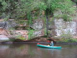
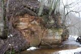
In the centre of Līgatne, on the right bank on the rapid Līgatne River, there is a viewing plan which offers a close-up look at one of the most impressive sandstone cliffs which rise above it – the Lustūzis cliff. There are artificial caves in the wall of the cliff, which locals use as cellars and as places to store their property.
|
|
 |
These meadows are of distinction because of the curvy Slampe River, which has caused a gradual recovery of damp meadows, complete with species of plants and animals that are typical of such areas. Domestic animals adapted for life in the wild can be seen here, and a bird watching tower on the location will offer you an excellent opportunity to view them. You can get to the meadows via a narrow corridor known as the Melnragu throat. The gravel road will lead to a hillock called Kurgāns from which you can have an excellent view of the surrounding landscape. |
|
|
|
This is the 11th largest Estonian island, and its central section is covered by a broadleaf forest (linden, oak, elm and other trees) that is more than 100 years old. Along the shores, the Abruka Island has meadows and small areas of wetlands. Only the northern part of the island is populated. Few tourists come to call, which means that the island is relatively untouched by humankind.
|
|


