
| No | Name | Description |
|---|---|---|
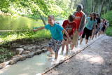 |
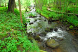
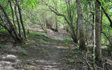
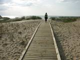
The first barefoot trail created in the Baltic States in the recreation complex "Valguma pasaule", which is located on the forested shores of Lake Valguma. When walking on the path, the feet "massage" sand, wood chips, clay, peat, gravel, cones and various other materials. |
|
 |
1,8 km garā taka atrodas neparastā vietā – uz Cirīša ezera salas. Tās galvenās vērtības ir augu valsts un dzeņveidīgo putnu daudzveidība. Viens no apskates objektiem ir Upurkalns – sens pilskalns. Taka labiekārtota, izveidoti informācijas stendi, atpūtas vieta. Lai nokļūtu uz salas, no vietējiem jānomā laiva, vai jādodas ar savējo. Atrodas dabas parkā „Cirīša ezers”. |
|
 |
Plieņciema taka atrodas dabas liegumā "Plieņciema kāpa" starp Plieņciemu un Ķesterciemu. Pāri kāpai ir izveidota laipu taka un atpūtas vieta. Taka ir izveidota, lai mazinātu negatīvo ietekme uz Plieņciema kāpas dabas vērtībām – zemsedzes nomīdīšanu, piegružošanu ar atkritumiem, braukšanu ar autotransportu.
|
|
|
|
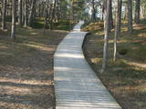
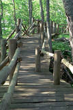
In 2006, a wooden pathway was installed across the Planči swamp – 500m long, which means that the visitor will spend around 20 minutes there. This is probably the only nature trail in Latvia for which there are plans to post information in Braille for people with impaired vision.
|
|
 |
The beginning of this circular trail can be found at the Krimulda church – the oldest in Latvia. In one direction, the tourist will pass along the banks of the little Runtiņupīte river (Runtiņš) to the place where it flows into the Gauja river. Among the points of interest along the way are the parsonage of the church, the Kubesele castle hill, a memorial to the Livonian chieftain Kaupo, the Kubesele cave, the Saulstari rock, the “Great Rock”, ancient anchor blocks, ancient graveyards, a unique labyrinth, etc.
|
|
 |
Taka izveidota 2005. gadā. Tā atrodas uz Lapmežciema un Bigauņciema robežas un izskatās kā koka dēlīšu laipa gar Siliņupi. Taka aizved līdz jūrai, kur apskatāms vecais Lapmežciema mols. Siliņupē novērojami ūdensputni. |
|
 |
A pathway of wooden trails and little bridges, featuring the most beautiful part of the Ieriķupīte river, with several waterfalls, an old windmill, a unique millwheel, and various areas of obstacles for active people in the company of a guide.
|
|
 |
Brīvdienu mājas "Korķi” apkārtnes priežu mežā ir izveidota Jāņtarpiņu taka. Ideāla vieta aktīviem sēnotājiem un ogotājiem. Savukārt saules un jūras cienītāji pa šo taku 5-10 minūšu gājienā nonāks Vitrupes pludmalē, kur varēs baudīt sauļošanās un peldēšanās priekus.
|
|
 |
Augstrozes pilskalna taka atrodas ainaviskā vietā, gleznainā 13. gadsimta pilskalnā, kas apvīts ar teikām un leģendām. No pils drupām paveras labākais skats uz lielisko ainavu, ko veido Augstrozes Lielezers un Ziemeļu purvi.
|
|
 |
Cena's heath swamp's trail was made to introduce vistors to one of the most beautiful things in nature - a moss swamp. The pathway goes not only around beautiful swamp lakes but also meets the degraded part of the swamp. At the beggining and the end is a watch tower. |
|
 |
4 km garā un marķētā taka iepazīstina ar dziļo Imulas ieleju – Abavas kreisā krasta pieteku. Īpaši iespaidīga ieleja izskatās bezlapu periodā, kad ir apjaušami tās izmēri un formas. Vēstures cienītāji var upes gultnē uzmeklēt Langsēdes Velna pēdas akmeni. Atrodas dabas parkā „Abavas senleja”. |
|
 |
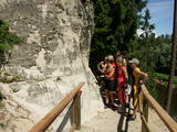
Taka ved gar Vaidavas krastu, kur iespējams veldzēties dabas skaistumā, kāds vērojams tikai šeit. Starp Apes vidusskolu un kapsētu Vaidavas upes kreisajā krastā ir izveidojušies 8 - 10 m augsti, līdz pat 100 m gari smilšakmens atsegumi - Raganu klintis. To lejasdaļā upes straume izskalojusi nelielas nišas. Pie klintīm pāri upei izveidots gajēju tiltiņš uz otru krastu, no kura klintis paveras visā savā krāšņumā. Te ir teikām un nostāstiem apvīti avoti un alas. Avots ar skaidru ūdeni iztek no vietas, kur Vaidavas upes smilšu klints krasts ir augsts un stāvs. Senāk vietējie ticējuši, ka tas ir veselības avots, jo daudzi to lietojuši dažādām acu slimībām.Dīvainos dabas objektus – Vilkaču priedi un Dvīņu priedes, Raganu slotu, “raganu apļus”, “raganu kaulus” u.c. te var apskatīt un vides gida vadībā mēģināt izprast to veidošanos
|
|
 |
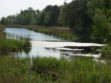
Overgrown with reeds, full of seashore meadows, lagoons, muddy little lakes and sandy shallows – this is the part of the Bay of Rīga shoreline which runs between Ainaži and Kuiviži. The Randi meadows are an important location for birds and plant life. It is a protected habitat with environmental restrictions. A bird-watching tower and nature trail have been installed so that visitors can study the meadows. The tour will take around one hour to complete. Objects are in the Northern Vidzeme Biosphere Reserve.
|
|
|
|
Ap 7 km garā apļveida taka sākas pie leģendārajām Mangaļu mājām. Tā iepazīstina ar latviešu strēlnieku kauju vietām, vietām, kur atradušās to fortifikācijas, t.s. „Vācu valni” u.c. liecībām. Mangaļu mājās – Ziemassvētku kaujām veltīts muzejs. |
|
 |
This circular trail features a unique landscape of parallel rampart-type sand dunes and grassy swamps among the dunes. The 3.5 km trail leads through a landscape that is unique in Europe and emerged some 6,000 years ago as the sea was receding. This landscape offers evidence of the geological history of the Baltic Sea. There is a high-type swamp (the Pēterzers swamp), along with remnants of an old narrow-gauge railway. Wooden pathways have been installed along the swamp and the surrounding wetlands. |
|
 |
The trail tells about the protected nature area which is found in Riga city and has been established to protect the seashore habitats (forests, meadows, reeds, dunes) and the birds, populating the daugavgrīva meadows. There is a bird watching tower with facilities for people with special needs.
|
|
 |
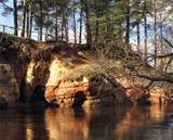
In terms of shape, this is one of the most diverse areas of uncovered sandstone in Latvia. Found on the right bank of the Gauja river, the Sietiņiezis is up to 15m high. Small holes that can be seen in the cliff face are created by single and protected insects, which carve tiny caves in the cliff for their caterpillars. A circular and well appointed trail, with stairs, has been installed. It is 1.5 km in length and will take an hour or so to traverse. Objects are in the Gauja National Park.
|
|
 |
Dabas takā gar Rojas upi iespējamas 3 dažāda garuma distances, kas lokveidā ved gar upi un tai pieguļošajiem mežiem – 2 km, 7 km un 15 km, kas katra atzīmēta ar savas krāsas norādēm. Dzeltenais aplis 2 km, zilais aplis – 7 km, sarkanais aplis – 15 km. Maršrutus var veikt arī ar velosipēdu, taču braucot ar velo, atsevišķi posmi var būt grūti izbraucami smilšu dēļ. Pie upes ierīkotas vairākas atpūtas vietas ar soliem, galdiem, labierīcībām, šūpolēm, vingrošanas konstrukcijām, atkritumu urnām, kā arī ugunskura un telšu vietām. Pie atpūtas vietām Žocenē un Rojā ir izveidotas arī laivu piestātnes. Takas sākumā upes krastā labiekārtota vieta, kur upē ietek Rojas avots, ko kā ūdensņemšanas vietu iecienījuši vietējie iedzīvotāji. |
|
 |
The Dinaburga trail first goes downhill, and then it quickly goes uphill to the steep shores of the Daugava river. Among a set of gullies, there is the Naujene (Vecpils) castle hill – some 25m high and the “cradle” of the city of Daugavpils. The ruins of the castle are still visible, and a unique open-air model of the old Dinaburga castle has been prepared. There is a lovely view of the Daugava river valley, and the visitor can expect to spend 20 minutes to an hour here. Objects are located in a protected area of Augšzeme landscapes and in the Curves of Daugava nature park.
|
|
|
|
Ap 9 km garā taka (vienā virzienā) sākas Skaņākalna dabas parkā (Mazsalacā) un beidzas pie Ramatas. Tā iepazīstina ar Salacas ielejas dabas parka nozīmīgākajām vērtībām – smilšakmens atsegumiem (Skaņaiskalns, Dauģēnu klintis u.c.), alām, nozīmīgu izmēru laukakmeņiem u.c. Taka marķēta. Tajā izvietoti informācijas stendi, norādes. Jāpadomā par loģistiku – kā nokļūt sākuma punktā. |
|
