
| No | Name | Description |
|---|---|---|
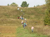 |
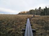
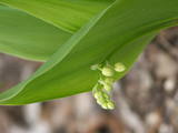
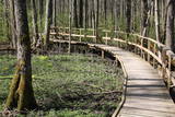
The Markova information trail is the most diverse and impressive trails along the upper reaches of the Daugava river in terms of objects and landscapes. The visitor will go to the top of the Markova castle hill, which offers a great view of the river valley. The deep Putāni stream valley will be crossed to get to the cliffs on the right bank of the Daugava. Here, the visitor will see one of the most unusual landscapes of Latvia’s river valleys. There is the Slutišķi village of Old Believers, along with the mighty Slutišķi cliff in the background. The trail is 1.6km long, and it will take an hour or two, particularly if the visitor chooses to tour the village and the homes of the Old Believers.
|
|
 |
Here the visitor will find an ecological tourism trail in the ancient Embūte valley. The hills around Embūte date back to the Ice Age. There are valleys and forests of many fallen trees which are protected habitats. The visitor will learn about important natural and cultural monuments – the Embūte castle hill, as well as the ruins of a baronial estate, a castle and a church. The Courlandian chieftain Indulis died in the region. The visitor can view the Devil’s Dam, along with meadows, a viewing tower, etc. There are bicycler routes in the region. The site is located in the Embūte nature park. |
|
 |
1.2 km long, the trail passes through a unique terrain of hillocks and forests, with the height of the valley rising to as much as 15 metres. Visitors will find a diversity of plant life, as well as the beautiful little Kauliņupīte River, which crosses the rail at two points. The health trail was established in the late 1990s. |
|
 |
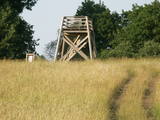
This is a trail for hikers and bird-watchers, located in a very interesting place on the shore of the Bay of Rīga near Kaltene. The visitor will see small inlets and capes and a rocky or overgrown shore. At the end of the trail there is a bird-watching tower. During the spring and autumn migrations of birds, the visitor will see a great many different kinds of birds in the area – geese, plovers, etc. The length of the track is a bit more than one kilometre, and it will take 20 minutes to an hour to cover.
|
|
 |
Taka atrodas Riekstusalas pussalā, netālu no putnu vērošanas torņa. Uz peldošiem pontoniem celtā laipa iepazīstina ar Kaņiera ezeru „tuvplānā”. Var iepazīt niedrājus, to putnus, labi redzamo ezera gultni ar zivju mazuļiem un kalcifilām augu sabiedrībām. Laipa aizved līdz salai, uz kuras aug kadiķi. |
|
 |
Because this circular trail is in a nature zone, it may only be traversed in the company of a guide from the Slītere Nature Park. A steep stairway that has been installed along the ancient shores of what was once a Baltic lake of ice will lead the visitor to a completely different world, one with fallen trees, broadleaf forests, an area in which underground streams create aboveground wetlands, a limy and grassy swamp (all of these are protected areas), remains of old-time reclamation ditches, and rotting fir stumps which are important in terms of the diversity of species and which have been in the region since a major windstorm in 1969. The trail is 1.2 km long and will take an hour to an hour-and-a-half to traverse. The trail begins at the Slītere lighthouse, where the SNP visitors’ centre is located (in tourist season).
|
|
 |
Takas sākums atrodas pie Veclaicenes pagasta pārvaldes (autosvālaukums). Tā izlokas gar Ievas, Trumulīša un Raipala ezeru dienvidu krastiem un pa ziemeļu krastu nogāzēm atgriežas atpakaļ sākumpunktā. Apļveida takas garums – ap 8 km. Atrodas Augšzemes aizsargājamo ainavu apvidū, Kornetu – Peļļu subglaciālajā vagā. |
|
 |
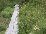
This territory was established to protect the rare tree specie in Latvia - common hornbeam, which covers approximately 4% of the territory, but the most visually interesting part of the area is the Tīrspurvs swamp, also known as the Dunika heath. This is where the visitor will find Latvia’s longest and most impressive swamp footpaths, which crosses the area from the North to the South. Visitors will be fascinated by the unique landscape of the central part of the swamp, where in some places there are not even small swamp pine trees. Various habitats will be found – small swamp lakes, mineral islands, marsh pools, etc., and that is to say nothing of all the birds in the area. |
|
 |
This is an uncommon trail. The visitor will learn all about quite “ordinary” trees such as the oak, the linden, the hazelnut, the fir and the pine. The information is quite interesting, however, making use of the heritage of Latvian folklore. The site is located near the Zvārte rock. Visitors will spend around one hour on the trail.
|
|
 |
Atrodas mežā, netālu no Kaltenes. Labiekārtota (laipas, kāpnes, informācijas stendi) taka, kas iepazīstina ar Latvijai samērā neparastu dabas pieminekli (aizsargājams) – Kaltenes kalvām, kas ir lieli, līdztekus Rīgas jūras līča krasta līnijai orientēti laukakmeņu krāvumi. Uzskata, ka tos veidojuši Baltijas ledus ezera ūdeņi un ledi. Garums – ap 1,5 km. |
|
 |
Taka veidota gar Gaujas labo krastu augšpus un lejpus Gaujienas un tā iepazīstina ar nogāžu mežu un dažādu pļavu biotopiem. Visā tās garumā izvietoti informatīvi stendi. Takas daļu lejpus Gaujienas var braukt ar velosipēdu.
|
|
 |
Teritorijas apskates nolūkos ir izveidota un labiekārtota dabas izziņas taka. Dabas liegums atrodas Abavas senlejas dabas parka teritorijā. Taka iepazīstina ar vienīgo krūmu čužas savvaļas augšanas vietu Latvijā. |
|
|
|
Vikmesti dēvē arī par Foreļstrautu, jo tā ir nozīmīga foreļu un taimiņu nārsta vieta. Gaujas labā krasta pieteka ir izveidojusi dziļu gravu ar stāvām nogāzēm, kuras lejtecē izveidojušies nelieli – ap 4 m augsti smilšakmens atsegumi. Gravas labajā (rietumu pusē) paceļas ar mežu apaugušais Vikmestes pilskalns. Gar Vikmestes upi izveidota taka, kuras sākumdaļa atrodas pie Siguldas – Turaidas ceļa, bet beigu daļa – pie Raganas – Turaidas ceļa (ap 3 km). |
|
 |
The trail tells about the protected nature area which is found in Riga city and has been established to protect the seashore habitats (forests, meadows, reeds, dunes) and the birds, populating the daugavgrīva meadows. There is a bird watching tower with facilities for people with special needs.
|
|
 |
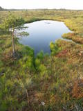
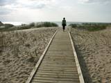
This circular trail features a unique landscape of parallel rampart-type sand dunes and grassy swamps among the dunes. The 3.5 km trail leads through a landscape that is unique in Europe and emerged some 6,000 years ago as the sea was receding. This landscape offers evidence of the geological history of the Baltic Sea. There is a high-type swamp (the Pēterzers swamp), along with remnants of an old narrow-gauge railway. Wooden pathways have been installed along the swamp and the surrounding wetlands. |
|
 |
In terms of shape, this is one of the most diverse areas of uncovered sandstone in Latvia. Found on the right bank of the Gauja river, the Sietiņiezis is up to 15m high. Small holes that can be seen in the cliff face are created by single and protected insects, which carve tiny caves in the cliff for their caterpillars. A circular and well appointed trail, with stairs, has been installed. It is 1.5 km in length and will take an hour or so to traverse. Objects are in the Gauja National Park.
|
|
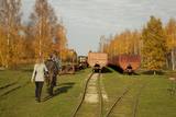 |
Sedas purva kājnieku maršruts atrodas dabas liegumā Sedas purvs, pārgājienu pa maršrutu iespējams apvienot ar Sedas pilsētas apskati, kas ir unikāls 20.gs. 50.–60. gadu pilsētbūvniecības un arhitektūras paraugs - kūdras purva strādnieku pilsēta. Maršrutam ir divi apļi - Jērcēnu aplis - 5,5 km un Sedas aplis - 4,2 km. Tajos apakatāms izstrādātais kūdras purvs, šaursliežu dzelzceļš, ritošais sastāvs, divi skatu toņi. Rudenī un pavasarī - putnu migrācijas lāikā - interesanta vieta putnu vērošanai. GPS koordinātes: Jērcēnu puses aplim: 57.7055987, 25.7001324; Sedas puses aplim: 57.6699587, 25.7514815. |
|
 |
This is a route for hikers and bicyclists, starting at the village of Vaidava and then moving along the eastern shore of the narrow Lake Vaidava, which has steep cliffs around it. The trip covers the Veļķi baronial estate, the “Swedish pine”, the famous Vaidava (Metimne) hillfort, a series of streams, the great Rubene rock, the Vaidava baronial estate on the western shore of the lake. After that, the trail leads the visitor back to the starting point.
|
|
 |
Uz pāļiem veidotā koku laipu taka līkumo cauri Vēršupītes dumbrājiem (pārmitri platlapju meži), tādēļ visiespaidīgākie skati šeit ir vērojami tieši pavasara palos vai citos gadalaikos pēc lielām lietavām, kad mazā upīte iziet no krastiem un appludina dumbrājus lielākā platībā. Par teritorijas sezonālu applūšanu liecina arī daudzo alkšņu resnie sakņu kakli, kas nevilšus atgādina mangrovju audzes. Mitrie meži ir viens no sugu skaita ziņā daudzveidīgākajiem Latvijas biotopiem.
|
|
 |
Dabas liegumā "Pilskalnes Siguldiņa" ir izveidota dabas taka - kājinieku tūrisma maršruts – t.s. Augšzemes ainavu taka, kas sākas Pilskalnē un beidzas pie Driģeņu mājām. Tā izlīkumo ezeru krastus, šķērso purvu (laipas). Apmeklētājiem, t.sk. arī bērniem, izveidotas arī īsākas - lokālas takas. Pieejami dažādu taku garumi: 1,6 km, 3,8 km, 8 km. |
|
