
| No | Name | Description |
|---|---|---|
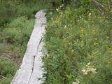 |
Teritorijas apskates nolūkos ir izveidota un labiekārtota dabas izziņas taka. Dabas liegums atrodas Abavas senlejas dabas parka teritorijā. Taka iepazīstina ar vienīgo krūmu čužas savvaļas augšanas vietu Latvijā. |
|
 |
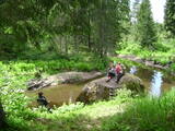
Brīvdienu mājas "Korķi” apkārtnes priežu mežā ir izveidota Jāņtarpiņu taka. Ideāla vieta aktīviem sēnotājiem un ogotājiem. Savukārt saules un jūras cienītāji pa šo taku 5-10 minūšu gājienā nonāks Vitrupes pludmalē, kur varēs baudīt sauļošanās un peldēšanās priekus.
|
|
 |
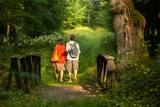
One of the few places in Latvia where there are so many well-organised pathways. The region is known for castle hills, the location where the great Latvian author Anna Brigadere (1861-1933) lived and worked, the storybook character figures that are scattered around that area, a great forest, an arboretum, a museum of history, a viewing tower, landscapes, etc. This has been recognised as the most family-friendly place in the country.
|
|
 |
Nature trail "Curves of Riva" starts at Ulmale-Labraga Lutheran Church and continues 3 kilometres down the picturesque downstream of river Riva. Rīva here flows in a canyon-type ravine which reaches 12 meter rise at some points. The trail reveals countless river twists and turns and steep coastal cliffs. The trail is partly accessible with an assistant and is marked with green paint. |
|
 |
Kartavkalnā, kur senāk atradusies seno zemgaļu apmetne, ir izveidota dabas taka ar soliņiem, piknika vietām. Šeit apskatāms arī Jaunpils Kartavu kalns un lapegļu aleja, kā arī iespējams aplūkot, kāda izskatās senlatviešu apmetne ar īstu guļbaļķu sētu.
|
|
 |
The Ungurmuiža park is well known for its outstanding and huge oak trees. Some of them are rotting or dead, and they are home to a great many species, including many that are found nowhere else in Europe. A pathway leads through these noble trees – 1.3km in length, with visitors spending as much as an hour there. The park also contains the only wooden castle from the early 18th century that has been preserved to the present day. There are other cultural and historical treasures, as well.
|
|
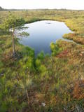 |
This territory was established to protect the rare tree specie in Latvia - common hornbeam, which covers approximately 4% of the territory, but the most visually interesting part of the area is the Tīrspurvs swamp, also known as the Dunika heath. This is where the visitor will find Latvia’s longest and most impressive swamp footpaths, which crosses the area from the North to the South. Visitors will be fascinated by the unique landscape of the central part of the swamp, where in some places there are not even small swamp pine trees. Various habitats will be found – small swamp lakes, mineral islands, marsh pools, etc., and that is to say nothing of all the birds in the area. |
|
 |
Lots of wild animals can be found in vast paddocks along the ancient Gauja river valley and its small tributaries – areas in which living conditions are as close to natural circumstances as possible. Here the visitor can find, if lucky, reindeer, deer, wild boars, bears, foxes, lynx, various kinds of birds, as well as aurochs. There is a dense network of pathways in the park, including lots of information. There is also a route for drivers and bicyclists. During the winter, it is used for distance skiing. There is also a visitors’ centre.
|
|
|
|
Ap 7 km garā apļveida taka sākas pie leģendārajām Mangaļu mājām. Tā iepazīstina ar latviešu strēlnieku kauju vietām, vietām, kur atradušās to fortifikācijas, t.s. „Vācu valni” u.c. liecībām. Mangaļu mājās – Ziemassvētku kaujām veltīts muzejs. |
|
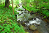 |
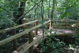
A pathway of wooden trails and little bridges, featuring the most beautiful part of the Ieriķupīte river, with several waterfalls, an old windmill, a unique millwheel, and various areas of obstacles for active people in the company of a guide.
|
|
|
|
Labiekārtota (informācijas stendi, atpūtas vietas) un marķēta taka, kas ved apkārt Kokšu ezeru virknei, kurā ietilpst Zāļu, Dziļais un Dibena ezers. Iepazīstami mežu biotopi, dzīvnieki un to darbības pēdas. Iespējami trīs dažādi takas izziešanas varianti: 7 km, 4,5 km, 2,7 km. Maršrutu var braukt ar divriteni. Ietilpst Ziemeļvidzemes biosfēras rezervātā. |
|
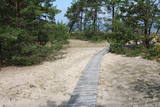 |
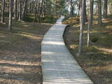
The trail (the length 1.2 km) introduces with the habitats of dunes and century-old pines, partly covered with sand. Biologists estimate that the oldest tree, the “mother of pines”, could be around 200 years old. Coastal pine forests serve as a barrier between the sea and land protecting inland areas from impact of the sea and winds. Felling coastal forests was forbidden by law already back in 1643, during the Duchy of Courland. Still due to economic activities, the seashore forests were often fell and fires occurred there occasionally. As a result, the sand which had for centuries been hold by trees, started drifting at Cape Kolka. In the 1930ies, there were about 142 hectares of sandy areas in the Slītere National Park, and 11.5 hectares of those were drifting sand. To stop drifting, the sand areas were carefully afforested. Afforestation was started before WW I and it was completed in the 1970ies. To plant new trees, first the sand had to be stopped. Just 26km to the south from Kolka there was one of the largest sand dunes in Latvia, 25km in length. Every year it devoured 0.3 hectares of land. The sand was stopped covering it with heather, twigs and branches of pines and junipers. Pine trees were planted between them. Today in Kolka, the old, low pine trees tell about the once drifting sand. After storms, when the water washes the bluff and tree roots are exposed, one can see that the tree trunks once have been covered with sand more than 1 meter high. The trees on the seacoast usually have crooked trunks and flag-shaped crowns formed under influence of persisting sea winds. Now these forests are designated biotope “Wooded dunes of the coast”. Stable white dunes (biotope 2120) do not form in Cape Kolka as they are washed by sea waters during spring and autumn storms. Embryonic dunes develop here (code 2120) with plants that usually grow in dunes. These plants have adapted well to poor soils, heat, drought, and the saline sea water. The Kolkasrags Pine Trail is in Slītere National Park. |
|
 |
The wooden pathway which crosses the high swamp leads to the Teirumnīku swamp lake, which is right in the middle of the swamp. On the shores, there is a well-appointed place for leisure and relaxation. One can return to the starting point via a forest path. The trail is 800m long, and visitors will spend about an hour there. It is a part of the Tīrumnieki nature reserve.
|
|
 |
Taka veidota gar Gaujas labo krastu augšpus un lejpus Gaujienas un tā iepazīstina ar nogāžu mežu un dažādu pļavu biotopiem. Visā tās garumā izvietoti informatīvi stendi. Takas daļu lejpus Gaujienas var braukt ar velosipēdu.
|
|
 |
Informatīvi bagāta un interesanta dabas izziņas taka, kas ved pa Gaujas tuvumā esošajiem krasta biotopiem – boreāliem mežiem, nogāžu mežiem, gar vecupi, jauktiem lapu koku un platlapju mežiem, kā arī parkveida ozolu pļavām. Ziemeļgaujas aizsargājamo ainavu apvidū esošie meži ir vieni no sugām daudzveidīgākajiem Latvijā. Taka ir marķēta, izveidotas skatu platformas, izvietoti informatīvie stendi. Kopējais takas garums: 2,2 km |
|
 |
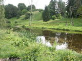
This path is found on the right bank of the ancient Abava river valley. The visitor will be able to view places where underground streams create wetlands, various kinds of meadows, a stand of juniper bushes, etc. The area is “managed” all year long by “wild” cows. The shore of the ancient valley can be climbed (some 200 steps), and the view is magnificent. It is recommended that the trail be visited in the company of a knowledgeable guide. There is a shorter path that is 600m long, along with a longer one that is more than a kilometre in length. It will take an hour or so to traverse it. Objects are found in the ancient Abava valley nature park.
|
|
 |
Pie Gārsenes pils atrodas bijušais muižas parks 4ha platībā un pie tā sākas arī Gārsenes dabas takas. Dabas takas vēsturiski tika veidotas vienlaicīgi ar pils kompleksa būvniecību un ieeja takās atrodama pie mākslīgi veidotā, ar bruģa pamatni izliktā barona peldēšanās dīķa. Takas sākumā saglabājusies ošu aleja, ko savulaik stādījis barona dārznieks, savukārt taku vidusposmā apmeklētājiem ir iespēja pasēdēt uz Barona krēsla - akmens ar cilvēku veidotu sēdvietu tajā. Kopumā Gārsenes mežā vijas dažāda garuma labiekārtotas pastaigu un izziņas takas - Kultūrvēsturiskā taka, Zaļā taka, Baronu pastaigu taka, Staburaga taka, ar ierīkotām atpūtas un ugunskuru vietām. Takās apskatāmi vairāk kā 40 unikāli dabas objekti, gan dižakmeņi, gan dižkoki, kā arī un pagasta ievērojamākie arhitektūras un kultūrvēstures pieminekļi. No 2016.gada maija Dabas takās ietilpst arī „Krēslas stundas taka”, kas īpaši patiks zinātkāriem mazajiem ceļotājiem. Taka stāsta par Rūķu dzīvi mežā un tās veidošanas pamatā ir stāsti no „Lielās Rūķu enciklopēdijas”. |
|
 |
Plieņciema taka atrodas dabas liegumā "Plieņciema kāpa" starp Plieņciemu un Ķesterciemu. Pāri kāpai ir izveidota laipu taka un atpūtas vieta. Taka ir izveidota, lai mazinātu negatīvo ietekme uz Plieņciema kāpas dabas vērtībām – zemsedzes nomīdīšanu, piegružošanu ar atkritumiem, braukšanu ar autotransportu.
|
|
 |
Ģeoloģiskā taka sastāv no trīs saistītiem posmiem: „Melturi – Kārļu zivjaudzētava”, „Kārļu zivjaudzētava – Zvārtes iezis” un "Zvārtes iezis - Veclauču tilts". Amatas senleja veidojusies vienlaikus ar Gaujas senleju leduslaikmeta beigu posmā un pēcleduslaikmetā, ledāja kušanas ūdeņiem plūstot uz Gaujas ieleju. Gaujas NP teritorijā Amatas senielejas dziļums sasniedz 50 metrus un platums palielinās līdz apmēram 1-1,5km.
Augstas kraujas (vairāk ne kā 40 metru), kurās redzami augšdevona Pļaviņu svītas dolomītu un augšdevona Amatas un Gaujas svītu smilšakmeņu atsegumi, mijas ar mežiem apaugušām, 3-16m augstām stāvām terasēm.
Amatas senieleja ir nozīmīga ne tikai ar savām dabas ainavām. Tās krastus grezno dolomīta un smilšakmens atsegumi, kas atklāj zemes vēstures lappuses 350-400 miljonu gadu tālā pagātnē, kad Latvijas teritoriju klāja jūra.
Velobraucieniem taka nav piemērota!
|
|
 |
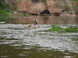
The trail tells about grey dunes which have survived thanks to the border restrictions and the presence of military. The trail starts from the parking place at the mouth of the Užava river. It is one of the few natural rivermouths in Europe. One can also see the „tacis”, an industrial installation for lamprey (Lampetra fluviatilis) fishing during their spawning migration period. The 3km long trail is circular. It winds for 1.5km from the Užava rivermouth to the North, along the coastline (the beach is covered with sand and pebbles), and returns to the starting point by a gravel road through grey dunes. Along the trail, one can observe a distinct white dune with rare plant species Linaria loeselii, Lathyrus maritimus, Anthyllis arenaria, Tragopogon heterospermus. About 1km from the rivermouth, in the sea, one can see a wrack of a sailing ship (parts of frame). The visibility depends on the flow of sand in the sea. The way back opens a beautiful view of the range of grey dunes. Unfortunately, Scots Pine starts taking over the area. There are three important biotopes of EU significance: „Fixed dunes with herbaceous vegetation 2130”, „Decalcified fixed dunes with Empetrum nigrum 2140” and „Dunes with Salix arenaria 2170”, forming a unique mosaic. Typical species here: mountain Alison ‘(Alyssum gmelinii), Pasqueflower (Pulsatilla pratensis), Sand Pink (Dianthus arenarius), Rosemary Leaved Willow (Salix rosmarinifolia), Dark Red Helleborine (Epipactis atrorubens), Kinnikinnick (Arctostaphylus uva-ursi). As a former military site, some military constructions can be seen here like horseshoe-shaped sand ramparts by the road in gray dunes. They were built to disguise military vehicles in case of sea attack. By the Kangroti graveyard, towards the Užava river, there is an underground pillbox. It is a one-man fortification to fire along the coastal perimeter. The Mouth of River Užava walking route is in the nature reserve „Užava” |
|
