
| No | Name | Description |
|---|---|---|
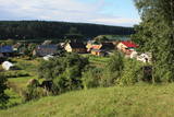 |
Karņicka kalns pēc savas izcelsmes nav kalns, bet gan Daugavas ielejas nogāzes daļa ar labu skatu uz Krāslavas mazstāvu koka apbūvi. Ar šo vietu saistīts traģisks nostāsts par poļu virsnieka Josifa Karņicka un grāfa Plātera meitas mīlestību, kurai nebija lemts piepildīties tā laika „paražu” dēļ. Tā rezultātā abi nelaimīgie nolemj izdarīt pašnāvību. Virsnieks nošaujas, bet Emīliju pēdējā brīdī izglābj kalpone, neļaujot tai izlēkt pa pils logu. J. Karņicka pašnāvības vietā ir uzstādīts piemineklis. Nedaudz tālāk – rietumu virzienā guļ t.s. Austriņa akmens, pie kura 1909. gadā iedvesmojies un radījis latviešu rakstnieks Antons Austriņš. |
|
 |
The Krāču hills (Krāckalni) are a series of
wavy hillocks dating back to the Litorine Sea.
There is a lovely view of Lake Lilijas from here.
Opposite the lake, on the eastern side of the
road, are dolomite stairs which lead to a
monument dedicated to 90 Latvian riflemen who
lost their lives in battles in 1917 in the region.
|
|
 |
Lustužkalns Hill (72 m ASL). A hunting
castle owned by Livonian Order master
Walther von Plettenberg was located here
in the 16 century. During the reign of
Russian Empress Catherine the Great, a
recreational castle was built here. A
legend from the time says that a golden
carriage is at the bottom of the local Lake
Valgums.
|
|
 |
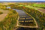
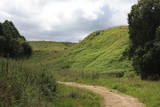
This nature park features the most beautiful and distinct parts of the Vanema hillocks in Northern Kurzeme, and the aim is to protect the hillocks of Talsi. This is one of the loveliest parts of Kurzeme, with small but distinct hillocks and ravines among them. There are small but fairly deep lakes in the area – the Lake Ābeļi, Lake Čumals, Lake Sirdsezers, etc. Some of them are reminiscent of nothing other than deep craters. The territory is very good for active tourists – hikers (there are nature trails), bicyclists, etc. |
|
 |
Volzbahs ir stāva nogāze ar elpu aizraujošu skatu pāri gravai. Ziemā šeit pieejams vairāk nekā 100 m garš nobrauciens ar slēpēm, sniega dēli vai ragaviņām. Citos gadalaikos Volzbaha kalns ir lieliska atpūtas vieta- šeit ir labiekārtota vieta piknikam, pastaigām, foto sesijām. Rudenī Volzbaha kalns ir viena no labākajām vietām Vaiņodes novadā, kur vērot krāšņos rudens skatus. Volzbahs atrodas 2 km no Vaiņodes centra ZR virzienā. Kalnam ērti var piebraukt klāt ar automašīnām. Adrese: Vaiņodes pagasts, Dienvidkurzemes novads, LV-3435 Facebook: facebook.com/biedribavolzbahs Twitter: Volzbahs |
|
 |
Īdeņa Castle mound is located near Lake Lubāns. A beautiful view
to the lake and to the marshy meadows. The place was inhabited from
the 11th century.
|
|
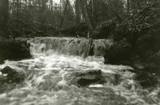 |
Here we find a set of canyon-type gullies among layers of dolomite. There are impressive outcrops and small waterfalls in the little river’s bed.
|
|
 |
Atrodas ~ 1,5 km ziemeļos no Krāslavas centra, Jāņupītes krastā (ir norāde). Pēc atsevišķiem savrupatradumiem var spriest, ka pilskalns apdzīvots laikā no I g. t. pr. Kristus līdz vēlajam dzelzs laikmetam. Domājams, ka savu nosaukumu tas ieguvis šeit sastopamo mālu dēļ. Nelielas mālu ieguves vietas pilskalna nogāzēs ir redzamas arī šodien. Saglabājies nostāsts, ka grāfs Plāters šeit apraudājis savu sievu, kuru pats neuzticības dēļ licis iemūrēt pazemē. |
|
 |
Iespaidīgs pilskalns ar izveidotu apskates taku. Blakus ūdenstūristu apmetne „Kvēpene”.
|
|
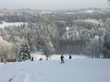 |
Gaiziņkalns Hill is the highest hill in Latvia, and it is a typical example of the hillocks of the Vidzeme highlands. This is a place of wonderful landscapes, even though there are not all that many good viewing areas. At the centre of this park is Gaiziņkalns Hill itself – the highest place in Latvia and the second highest in the Baltic States (311.6 metres above sea level). The viewing tower, alas is not open to the public, because it is in dangerous condition. There is a well-appointed hiking trail around Gaiziņkalns Hill, and during the winter the hill and its surroundings are popular for downhill and cross-country skiing. Lake Viešūrs (Lake Kaķītis) is popular among licensed fishermen. This territory is part of a region of protected landscapes around Vestiena. |
|
 |
The castle hill of Spriņģi. It is located near Rēzekne town and it is
interesting with its peculiar shape of the ruins.Archeological monument of local significance.
|
|
 |
Eine der eindrucksvollen Reliefgestaltungen im Baltikum. Bei Sigulda erreicht das Urstromtal eine maximale Tiefe von 85 m ( Breite ung. 1 km). Schöne Sandsteinaufschlüsse aus dem Devon ist ein Anziehungspunkt. |
|
 |
Sens pilskalns Abavas kreisā senkrasta nogāzē. Pēc sena nostāsta zviedru karavīri ar savām cepurēm to sabēruši virs sava ģenerāļa kapa. Tagad Zviedru cepures apkārtnē ziemā var braukt pa kalnu slēpošanas trasēm, bet vasarā – ar rodeļiem.
|
|
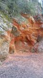 |
Sarkanās klintis savu vārdu ieguvušas pateicoties sarkanajiem iežiem. Tieši sarkanā ir mīlestības krāsa, tāpēc sarkanās klintis ir romatiska pastaigas vieta mīlniekiem. Smilšakmens klintīs redzamas plaisas, kas sašķeļ sarkanīgos iežus, radot neparastu dabas mākslas darbu. To virsma ir diezgan izrobota, kas veido klintīs nelielas alas un nišas. Sarkanajās klintīs ir arī daudz dažādu avotiņu. Pazīstamākais no tiem ir Rūcamavots. Tam ir šāds nosaukums, jo tas, nākot ārā no zemes, izdod nelielu rūkoņu. |
|
 |
Found on the right bank of the Daugava, approximately half a kilometre upriver from the Skrīveri Agricultural Institute, the hill is in a place where the bank of the Daugava River Valley is split by the deep Ašķere stream valley. The castle hill was occupied beginning in the first millennium BC, with antiquities from the Lettigalian and Livonian tribes found there. During the 13th century, a brick castle was built on the hill, but it was sacked during the 17th century. Nothing remains of the castle. The castle hill is also known as Raven Hills, and it offers one of the most beautiful views of the central part of the Daugava. In the direction of Rīga, there is a field with a white cross that represents an ancient church. There is a hiking trail along the Ašķere stream. The area is well improved with four trails. The longest is the Daugava trail (10 km). |
|
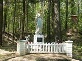 |
The castle hill of Milka is situated near Lake Sālaja and River Malta; 27m above the lake level. Local
businessman cleaned the hill and placed the statue of Mother of God there. It is a a symbol of Latgalian
strong faith into God and Virgin Mary.
|
|
|
|
Opekalns (arī Apukalns, Opekols) ir paugurs Alūksnes augstienē, 235 metrus virs jūras līmeņa, Veclaicenes pauguraines viena no augstākajām virsotnēm. Tā virsotnē uzcelta Opekalna luterāņu baznīca (1774—1779), kas ir visaugstāk virs jūras līmeņa novietotais dievnams Latvijā. Opekalna ciemā dzimis leģendārais Dziesmu svētku virsdiriģents Haralds Mednis. |
|
|
|
Одна из наиболее высоких дюн нашего побережья. В советское время в дюне велись копательные работы, так как песок использовался для производства силикатного кирпича. В 80-е годы ХХ века копательные работы были прекращены. Самая высокая часть дюны (хороший вид) сохранилась и поросла сосновым лесом. Создана природная тропа горы Пусену. Находятся в Бернатском природном парке. |
|
|
|
The restricted area was set up to protect Nesaule Hill, which is a forested hillock in the area and features boreal and damp forests.
|
|
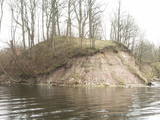 |
Where the little Rumbiņa river flows into the Daugava (on the left bank of the little river opposite the Lielvārde park), there is the Dievkalns castle hill that has been reduced by the waters of the Daugava. It is also known as the Cepure hill. According to antiquities that have been found here, representatives of Baltic tribes lived here from the first millennium BC to the 6th or 7th century AD. The level of the Ķegums hydroelectric power plant can be reached by a staircase from which the best view of this object can be found.
|
|

