
| No | Name | Description |
|---|---|---|
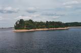 |
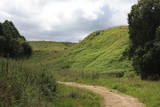
Before its flooding, the canyon of the Daugava River between Pļaviņas and Koknese was one of the most outstanding and beautiful parts of the Baltic terrain, and Oliņkalns hill was one of the largest castle hills in Latvia. The Andrejs cliff as up to 20 metres high, and it was part of the Daugava canyon. Before the area was flooded because of the construction of the Pļaviņas hydroelectric power plant, there were rapids near the hill that made it hard for rafters to sail down the river. Today it is a small island in the reservoir of the plant (it can be seen from the side of the Rīga-Daugavpils highway (A6) opposite Stukmaņi). It is separated from the shore by 300 metres of river, under which the Dūņas valley is now resting. A small part of the ramparts of the castle hill can still be seen on the island along with the ruins of an open-air stage and a few metres of the dolomite cliff that have remained above water. It is thought that the Alene castle was on the hill in the 13th century. Latvian mountain climbers installed a memorial stone in 1998 opposite Oliņkalns hill. |
|
 |
Одна из наиболее высоких дюн нашего побережья. В советское время в дюне велись копательные работы, так как песок использовался для производства силикатного кирпича. В 80-е годы ХХ века копательные работы были прекращены. Самая высокая часть дюны (хороший вид) сохранилась и поросла сосновым лесом. Создана природная тропа горы Пусену. Находятся в Бернатском природном парке. |
|
 |
Ap 0,5 km ziemeļaustrumos no Stukmaņu muižas – Daugavas ielejas labajā krastā atrodas Vīna kalns – sens pilskalns. Tajā atrodas izpostītie Stukmaņu muižas īpašnieku kapi. Mazliet tālāk redzams klajš upes ielejas nogāzes posms, kurā savulaik darbojās slēpošanas trase. |
|
 |
This structure is smaller than the Great Kangari hills – approximately 10 kilometres long and 16 metres high. This structure is near the Buļļi swamp, and the restricted area is meant to protect the structure, the swamp and the various forest types and rare plants that are in the area.
|
|
 |
The castle hill of Spriņģi. It is located near Rēzekne town and it is
interesting with its peculiar shape of the ruins.Archeological monument of local significance.
|
|
 |
Found on the right bank of the Daugava, approximately half a kilometre upriver from the Skrīveri Agricultural Institute, the hill is in a place where the bank of the Daugava River Valley is split by the deep Ašķere stream valley. The castle hill was occupied beginning in the first millennium BC, with antiquities from the Lettigalian and Livonian tribes found there. During the 13th century, a brick castle was built on the hill, but it was sacked during the 17th century. Nothing remains of the castle. The castle hill is also known as Raven Hills, and it offers one of the most beautiful views of the central part of the Daugava. In the direction of Rīga, there is a field with a white cross that represents an ancient church. There is a hiking trail along the Ašķere stream. The area is well improved with four trails. The longest is the Daugava trail (10 km). |
|
 |
Atrodas ~ 1,5 km ziemeļos no Krāslavas centra, Jāņupītes krastā (ir norāde). Pēc atsevišķiem savrupatradumiem var spriest, ka pilskalns apdzīvots laikā no I g. t. pr. Kristus līdz vēlajam dzelzs laikmetam. Domājams, ka savu nosaukumu tas ieguvis šeit sastopamo mālu dēļ. Nelielas mālu ieguves vietas pilskalna nogāzēs ir redzamas arī šodien. Saglabājies nostāsts, ka grāfs Plāters šeit apraudājis savu sievu, kuru pats neuzticības dēļ licis iemūrēt pazemē. |
|
 |
Ap 25 km gara un līdz 1,5 m plata vaļņveida reljefa forma Adzeles pacēluma dienvidu malā, kas apaugusi ar skujkoku mežu. Latvijā reti biotopi un nozīmīga daudzu aizsargājamu augu un dzīvnieku sugu dzīves vieta. Numerenes valni var ļoti labi "izjust", braucot pa Kārsavas - Tilžas ceļu. Dabas parkā atrodas slēpošanas kalns "Nūmerene".
|
|
 |
Where the little Rumbiņa river flows into the Daugava (on the left bank of the little river opposite the Lielvārde park), there is the Dievkalns castle hill that has been reduced by the waters of the Daugava. It is also known as the Cepure hill. According to antiquities that have been found here, representatives of Baltic tribes lived here from the first millennium BC to the 6th or 7th century AD. The level of the Ķegums hydroelectric power plant can be reached by a staircase from which the best view of this object can be found.
|
|
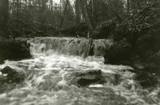 |
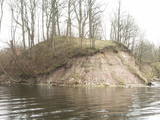
Here we find a set of canyon-type gullies among layers of dolomite. There are impressive outcrops and small waterfalls in the little river’s bed.
|
|
|
|
Iespaidīgs pilskalns ar izveidotu apskates taku. Blakus ūdenstūristu apmetne „Kvēpene”.
|
|
 |
This is another so-called hill left behind by the Ice Age – five kilometres long with a height of between 15 and 30 metres and with high hillocks and steep hillsides. Te most distinct part of the hill can be found between Lake Pinti and Lake Šeški. The pine forests on the hillocks are a habitat with many rare and protected species. A trail has been established to tour Grebļa Hill, as well as Āža Hill and Kausu Hill, but it is recommended that visitors travel the trail in the company of a guide. The biological diversity of the area is made clear if one knows, for instance, that more than 500 kinds of butterflies have been found in the restricted territory.
|
|
 |
The castle hill of Rasnupļi (Opiņķi) is a significant place on the foot of the hill inhabited by ancient Latgalians.
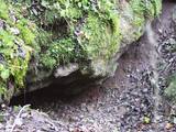
You will notice Velna ala (Devil’s cave) also called small Staburags of Latgale (ancient cult place)
in the right side of the Vīce river. It is a small natural geologically unique formation (length – 3m, width –
2m, high – 0,6m). There are only two such caves in Latvia. There are 5 – 6 m long stalactites.
|
|
