
| No | Name | Description |
|---|---|---|
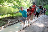 |
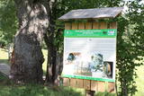
The first barefoot trail created in the Baltic States in the recreation complex "Valguma pasaule", which is located on the forested shores of Lake Valguma. When walking on the path, the feet "massage" sand, wood chips, clay, peat, gravel, cones and various other materials. |
|
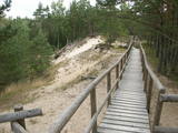 |
The trail climbs up and down along the bluffs of lower River Pilsupe and reveals a fascinating sight of three white dune exposures (the largest is called the White Dune). The trail is 900m long, and the White Dune is ca 20m high. It has formed ca 6000 years ago, in the period of the Littorina Sea which is a foregoer of the Baltic Sea. Here the first Stone Age settlement on the North Western coast of Latvia has been found in 1934 by geologist S. Burhards. In the sand, some 500m from the sea, he found some pottery fragments, a sandstone hone, a piece of flint, parts of bones and an amber bead. He handed the findings over to the National Museum of History. In October 1934, the site was checked by archaeologist E. Šturms, who found the archaeological layer, typical for such settlements, in the landslides of the Pilsupe riverbanks. In 1936 he started larger excavations to continue by 1938. Totally seven, chronologically different settlements were detected and many artefacts found, including fragments of the so called Sārnate and pit-comb pottery, as well as some pieces of corded pottery. Based on these findings, the settlement is dated back to the beginning or middle of the 3rd millenary B.C., and it has been inhabited till the beginning of the 2nd millenary B.C. Especially remarkable are three clay figures in human shape which have probably been used for some religious cult purposes. Since 1993, archaeologist Ilzes Loze has discovered several pit-comb ware culture settlements in large area around Pūrciems village. They are known in research literature as „the Ģipka settlements”. |
|
 |
Overgrown with reeds, full of seashore meadows, lagoons, muddy little lakes and sandy shallows – this is the part of the Bay of Rīga shoreline which runs between Ainaži and Kuiviži. The Randi meadows are an important location for birds and plant life. It is a protected habitat with environmental restrictions. A bird-watching tower and nature trail have been installed so that visitors can study the meadows. The tour will take around one hour to complete. Objects are in the Northern Vidzeme Biosphere Reserve.
|
|
 |
One of the few places in Latvia where there are so many well-organised pathways. The region is known for castle hills, the location where the great Latvian author Anna Brigadere (1861-1933) lived and worked, the storybook character figures that are scattered around that area, a great forest, an arboretum, a museum of history, a viewing tower, landscapes, etc. This has been recognised as the most family-friendly place in the country.
|
|
 |
The trail reveals one of the rare bluffs of the Gulf of Riga – the Ēvaži Bluff (up to 15m high, a beautiful scenery opens from its watching platform) and the seashore forests. The trail starts from the main road and crosses a biotope “Wooded dunes of the coast” (according to Habitats Directive, Annex II), which is frequently observed by the sea. One can climb down the stairs to an extraordinary beach with narrow seashore and Black Alders growing almost in the sea. There are occasional puddles which make shelter for Natterjack Toad (Bufo calamita), a protected amphibian. Deeper pools are inhabited by three-spined stickleback (Gasterosteus aculeatus), they are food for fish-eating birds. In the second half of the summer, Common Shelduck (Tadorna tadorna) can be observed in the sea. About two kilometres to the South, there is Melnsils, one of the Liv fishing villages, famous for the stories about a channel which was once dug to drain coastal lakes into the sea, as well as about Trommel, the chief of robbers. The trail is in the Slītere National Park. |
|
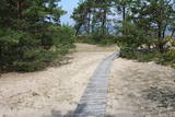 |
The trail (the length 1.2 km) introduces with the habitats of dunes and century-old pines, partly covered with sand. Biologists estimate that the oldest tree, the “mother of pines”, could be around 200 years old. Coastal pine forests serve as a barrier between the sea and land protecting inland areas from impact of the sea and winds. Felling coastal forests was forbidden by law already back in 1643, during the Duchy of Courland. Still due to economic activities, the seashore forests were often fell and fires occurred there occasionally. As a result, the sand which had for centuries been hold by trees, started drifting at Cape Kolka. In the 1930ies, there were about 142 hectares of sandy areas in the Slītere National Park, and 11.5 hectares of those were drifting sand. To stop drifting, the sand areas were carefully afforested. Afforestation was started before WW I and it was completed in the 1970ies. To plant new trees, first the sand had to be stopped. Just 26km to the south from Kolka there was one of the largest sand dunes in Latvia, 25km in length. Every year it devoured 0.3 hectares of land. The sand was stopped covering it with heather, twigs and branches of pines and junipers. Pine trees were planted between them. Today in Kolka, the old, low pine trees tell about the once drifting sand. After storms, when the water washes the bluff and tree roots are exposed, one can see that the tree trunks once have been covered with sand more than 1 meter high. The trees on the seacoast usually have crooked trunks and flag-shaped crowns formed under influence of persisting sea winds. Now these forests are designated biotope “Wooded dunes of the coast”. Stable white dunes (biotope 2120) do not form in Cape Kolka as they are washed by sea waters during spring and autumn storms. Embryonic dunes develop here (code 2120) with plants that usually grow in dunes. These plants have adapted well to poor soils, heat, drought, and the saline sea water. The Kolkasrags Pine Trail is in Slītere National Park. |
|
 | ||
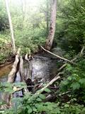 |
1.2 km long, the trail passes through a unique terrain of hillocks and forests, with the height of the valley rising to as much as 15 metres. Visitors will find a diversity of plant life, as well as the beautiful little Kauliņupīte River, which crosses the rail at two points. The health trail was established in the late 1990s. |
|
 |
Interesanta dabas izziņas taka, kurā izvietoti informatīvie stendi, kas stāsta par dažādiem pļavu biotopiem – sausām, palieņu un parkveida ozolu pļavām un tās iemītniekiem. Pļavas nogana dzīvei savvaļā pielāgotie mājlopi. |
|
 |
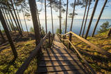
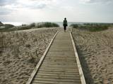
The Sunset trail starts in the centre of Saulkrasti town and takes you to the White Dune. Saulkrasti town with its municipal rural territory, occupies a 17km long stretch of coastal land to the North from the river Lilaste and the lake Lilaste. The White Dune stands on the right side of river Inčupe mouth. It is covered by old pine forest. The white, 18m high sand outcrop in olden times served as a landmark for fishermen. The White Dune formed as winds carried the sand from the beach over clay sediments of the Baltic Ice Lake. Some 150-200 years ago, the dune had been drifting as witnessed by several layers of soil buried within it. Local fishermen and farmers at Bātciems initiated afforestation of the drifting dunes. At that time, the 30m high dunes which are now covered with forest, were bare, shifting and even buried a farmstead. To speed up afforestation, mountain pines were planted. The White Dune was partly washed away in heavy storm in 1969, and 4-6m high precipice formed. Now the wind and sand have levelled out the dune surface, it has been fixed with willow-twigs or grown with forest where the largest pines are more than 170-190 years old. The pines are notable with their large trunks and branches, the scars obtained during their lifetime and the typical “crocodile skin” – the bark forms rhombuses resembling those of the reptile’s scales. Scots Pine (Pinus Silvestris) is one of the most common tree species in Latvia. It grows in dry, meagre sandy soil in dunes as well as in marsh. However, it does not stand overshadowing. Forest fires help pines to get rid of competitors as pine endures fire better than other trees because of its thick bark and high crown. The wood exudes resin and burned wounds close soon. Fire cleans space for seedlings of young pines. Pines can live 300-350 years. Ground cover in dune forests is very sensitive. If the sparse vegetation is destroyed, not only the natural biodiversity and landscape is damaged, but also the dangerous shifting dunes can possibly “wake up”. Embryonic dunes, White (yellow) dunes, Grey dunes and Wooded dunes are EU protected biotopes. Grey Dunes are protected by Latvian law as well. |
|
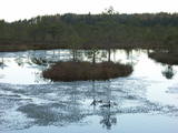 |
Teiči Nature Reserve — untouched territory, bogs, and birds. This is a significant bird resting place before seasonal migrations. Here you can see up to 1,500 cranes and 8,000 geese at once. The bog is a mating-place for black-cocks, therefore if you are near in an early spring, listen, and maybe you will hear these majestic mating calls. The trail can be visited only with the Nature Conservation Agency employee's escort from June 1 until October 31. |
|
 |
This is a tour that will take you trough time and space, because it clearly reveals the history of the location since the end of the Ice Age, which created the impressive ancient Gauja river valley. Uncovered sandstone leads one back to the Devonian period, known as the “fish age” – here we’re talking about history that dates back hundreds of millions of years. Human beings arrived in the region quite recently, but they’ve also left lots of evidence behind.
|
|
 |
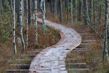
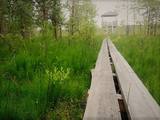
This circular trail features a unique landscape of parallel rampart-type sand dunes and grassy swamps among the dunes. The 3.5 km trail leads through a landscape that is unique in Europe and emerged some 6,000 years ago as the sea was receding. This landscape offers evidence of the geological history of the Baltic Sea. There is a high-type swamp (the Pēterzers swamp), along with remnants of an old narrow-gauge railway. Wooden pathways have been installed along the swamp and the surrounding wetlands. |
|
 |
Taka ap Ozolu Mazezeru. Purvaino krastu posmā, ap ezera rietumu galu, ierīkotas gājēju laipas. Novērojami purva, meža un ezera augi, dzīvnieki un biotopi. Jūlija beigās īpaši krāšņi zied ūdensrozes. Blakus atrodas Ozolmuiža ar parku.
|
|
 |
Asares muižas romantiskā stila dendroloģiskais ainavu parks veidots 18. gs. un papildināts 19. gs. 2. pusē. Muižas parka teritoriju ieskauj laukakmeņu mūris. Bet parkā sastopamas daudz interesantas krūmu un koku sugas: Sibīrijas baltegles, Eiropas lapegles, duglāzijas, šķeltlapainie baltalkšņi, Švedlera kļavas, košumkrūmi, dažādi lakstaugi. Liepu alejā - 2 dižkoki. Tempļa kalna atjaunotajā lapenē - muižnieku tējas dzeršanas vieta ar skatu uz pili. |
|
 |
The trail tells about the protected nature area which is found in Riga city and has been established to protect the seashore habitats (forests, meadows, reeds, dunes) and the birds, populating the daugavgrīva meadows. There is a bird watching tower with facilities for people with special needs.
|
|
|
|
Kartavkalnā, kur senāk atradusies seno zemgaļu apmetne, ir izveidota dabas taka ar soliņiem, piknika vietām. Šeit apskatāms arī Jaunpils Kartavu kalns un lapegļu aleja, kā arī iespējams aplūkot, kāda izskatās senlatviešu apmetne ar īstu guļbaļķu sētu.
|
|
 |
Taka ved cauri mežam uz skatu torni purva malā. Takā apskatāma Nāzara priede –priede, pie kuras 1905. gadā nošauts dumpinieks, pati priede – ekoloģiskais koks ar dzilnu kaltiem dobumiem, nokaltusi. Melnalkšņu dumbrājs - slīkšņa ar cūkaušiem un puplakšiem. Oleru purvs no skatu torņa – pārejas un sūnu purvs, kas izveidojies nolaista ezera vietā. Papildus objekti blakus takai, pieejami pa ceļu – Oleru muižas komplekss, Krustakmens, Oleru muižas kapi. Kopējais takas garums: 1,1 km. |
|
|
|
Andrupenes dabas takā var iepazīt sūnas, pārliecināties par sfagnu lielo ūdens uzsūkšanas spēju, gar laipas malām ieraudzīt apaļlapu raseni un purva dzērveni, apskatīt spilves, vaivariņus un purva vārnkāju, kā arī purva pasauli. Takas garums ~ 750m.
|
|
 |
Brīvdienu mājas "Korķi” apkārtnes priežu mežā ir izveidota Jāņtarpiņu taka. Ideāla vieta aktīviem sēnotājiem un ogotājiem. Savukārt saules un jūras cienītāji pa šo taku 5-10 minūšu gājienā nonāks Vitrupes pludmalē, kur varēs baudīt sauļošanās un peldēšanās priekus.
|
|
