
| No | Name | Description |
|---|---|---|
 |
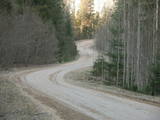
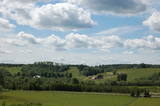
The Krāču hills (Krāckalni) are a series of
wavy hillocks dating back to the Litorine Sea.
There is a lovely view of Lake Lilijas from here.
Opposite the lake, on the eastern side of the
road, are dolomite stairs which lead to a
monument dedicated to 90 Latvian riflemen who
lost their lives in battles in 1917 in the region.
|
|
 |
Ap 0,5 km ziemeļaustrumos no Stukmaņu muižas – Daugavas ielejas labajā krastā atrodas Vīna kalns – sens pilskalns. Tajā atrodas izpostītie Stukmaņu muižas īpašnieku kapi. Mazliet tālāk redzams klajš upes ielejas nogāzes posms, kurā savulaik darbojās slēpošanas trase. |
|
 |
This restricted area protects the highest hillock in the Alūksne highlands – Dēliņkalns Hill – as well as the biotopes on its hillsides. The local landscape is also protected. Downhill ski trails are on the mountain, and its southern side offers lovely views.
|
|
 |
Where the little Rumbiņa river flows into the Daugava (on the left bank of the little river opposite the Lielvārde park), there is the Dievkalns castle hill that has been reduced by the waters of the Daugava. It is also known as the Cepure hill. According to antiquities that have been found here, representatives of Baltic tribes lived here from the first millennium BC to the 6th or 7th century AD. The level of the Ķegums hydroelectric power plant can be reached by a staircase from which the best view of this object can be found.
|
|
 |
Īdeņa Castle mound is located near Lake Lubāns. A beautiful view
to the lake and to the marshy meadows. The place was inhabited from
the 11th century.
|
|
 |
Found on the right bank of the Daugava, approximately half a kilometre upriver from the Skrīveri Agricultural Institute, the hill is in a place where the bank of the Daugava River Valley is split by the deep Ašķere stream valley. The castle hill was occupied beginning in the first millennium BC, with antiquities from the Lettigalian and Livonian tribes found there. During the 13th century, a brick castle was built on the hill, but it was sacked during the 17th century. Nothing remains of the castle. The castle hill is also known as Raven Hills, and it offers one of the most beautiful views of the central part of the Daugava. In the direction of Rīga, there is a field with a white cross that represents an ancient church. There is a hiking trail along the Ašķere stream. The area is well improved with four trails. The longest is the Daugava trail (10 km). |
|
 |
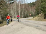
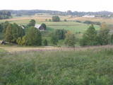
This nature park features the most beautiful and distinct parts of the Vanema hillocks in Northern Kurzeme, and the aim is to protect the hillocks of Talsi. This is one of the loveliest parts of Kurzeme, with small but distinct hillocks and ravines among them. There are small but fairly deep lakes in the area – the Lake Ābeļi, Lake Čumals, Lake Sirdsezers, etc. Some of them are reminiscent of nothing other than deep craters. The territory is very good for active tourists – hikers (there are nature trails), bicyclists, etc. |
|
 |
Zilais (Blue) Hill is the highest point in the Idumeja highlands – it is a very distinct hillock covered by forest, and from it there is a “narrow” landscape featuring the northern part of the highlands, as well as the Burtnieks flatlands. The restricted area is there to protect habitats such as gullies, hillsides and the boreal (northern) forest of the area. Zilais Hill is a popular tourist destination.
|
|
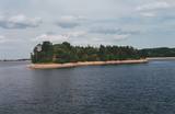 |
Before its flooding, the canyon of the Daugava River between Pļaviņas and Koknese was one of the most outstanding and beautiful parts of the Baltic terrain, and Oliņkalns hill was one of the largest castle hills in Latvia. The Andrejs cliff as up to 20 metres high, and it was part of the Daugava canyon. Before the area was flooded because of the construction of the Pļaviņas hydroelectric power plant, there were rapids near the hill that made it hard for rafters to sail down the river. Today it is a small island in the reservoir of the plant (it can be seen from the side of the Rīga-Daugavpils highway (A6) opposite Stukmaņi). It is separated from the shore by 300 metres of river, under which the Dūņas valley is now resting. A small part of the ramparts of the castle hill can still be seen on the island along with the ruins of an open-air stage and a few metres of the dolomite cliff that have remained above water. It is thought that the Alene castle was on the hill in the 13th century. Latvian mountain climbers installed a memorial stone in 1998 opposite Oliņkalns hill. |
|
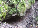 |
The castle hill of Rasnupļi (Opiņķi) is a significant place on the foot of the hill inhabited by ancient Latgalians.
You will notice Velna ala (Devil’s cave) also called small Staburags of Latgale (ancient cult place)
in the right side of the Vīce river. It is a small natural geologically unique formation (length – 3m, width –
2m, high – 0,6m). There are only two such caves in Latvia. There are 5 – 6 m long stalactites.
|
|
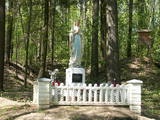 |
The castle hill of Milka is situated near Lake Sālaja and River Malta; 27m above the lake level. Local
businessman cleaned the hill and placed the statue of Mother of God there. It is a a symbol of Latgalian
strong faith into God and Virgin Mary.
|
|
 |
Karņicka kalns pēc savas izcelsmes nav kalns, bet gan Daugavas ielejas nogāzes daļa ar labu skatu uz Krāslavas mazstāvu koka apbūvi. Ar šo vietu saistīts traģisks nostāsts par poļu virsnieka Josifa Karņicka un grāfa Plātera meitas mīlestību, kurai nebija lemts piepildīties tā laika „paražu” dēļ. Tā rezultātā abi nelaimīgie nolemj izdarīt pašnāvību. Virsnieks nošaujas, bet Emīliju pēdējā brīdī izglābj kalpone, neļaujot tai izlēkt pa pils logu. J. Karņicka pašnāvības vietā ir uzstādīts piemineklis. Nedaudz tālāk – rietumu virzienā guļ t.s. Austriņa akmens, pie kura 1909. gadā iedvesmojies un radījis latviešu rakstnieks Antons Austriņš. |
|
 |
This structure is smaller than the Great Kangari hills – approximately 10 kilometres long and 16 metres high. This structure is near the Buļļi swamp, and the restricted area is meant to protect the structure, the swamp and the various forest types and rare plants that are in the area.
|
|
 |
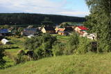
Is an ancient Courlandian castle hill and is found in the very centre of Alsunga. It was named in 1659 when General Berg from Kurzeme put cannons on it to attack Swedish forces that had fortified themselves in the Alsunga castle. The hill is 8 to 10 metres high and 24 x 54 metres wide, offering a lovely view of the St Michael Roman Catholic Church, as well as the Alsunga windmill lake that is alongside it. There is a distinct terrace around the hill, and it once was the foundation of wooden defensive structures. On the other side of the street, to the West of the castle hill, is a cemetery with fire graves of Courlandians that date back to the 11th to 13th century. Archaeologists examined the area during the middle part of the last century. The Suiti celebrate Easter and other holidays on the hill. |
|
 |
Kirkas Hill in Micāni. In 1792, a small castle on the hill Priežukalns (Kirkas kalns) was rebuilt into
Lutheran Church. Nowadays, the hill still is called Kirkas kalns (in German „Kirche” means „church”).
Old people say – under the church there is a big cellar where the jewellery of church and the Mantefel
family is hidden; Manteifel family vault is there too.
|
|
 |
This is one of the most impressive and extensive natural structures of its kind in Latvia in terms of appearance and landscape. The ice age left behind this wall-like terrain, which is up to 27 metres high and at the top of which the Rīga-Ērgļi road has been built. The Great Kangari hills offer a view of the Great Kangars lake and the Great Kangari swamps and ponds. The Ķoderi castle hill, also known as the “Big Man’s Bed” is found here. The restricted area was established to protect the structure and its related biotopes and plants.
|
|
 |
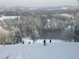
Sens pilskalns Abavas kreisā senkrasta nogāzē. Pēc sena nostāsta zviedru karavīri ar savām cepurēm to sabēruši virs sava ģenerāļa kapa. Tagad Zviedru cepures apkārtnē ziemā var braukt pa kalnu slēpošanas trasēm, bet vasarā – ar rodeļiem.
|
|
 |
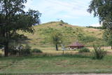
Gaiziņkalns Hill is the highest hill in Latvia, and it is a typical example of the hillocks of the Vidzeme highlands. This is a place of wonderful landscapes, even though there are not all that many good viewing areas. At the centre of this park is Gaiziņkalns Hill itself – the highest place in Latvia and the second highest in the Baltic States (311.6 metres above sea level). The viewing tower, alas is not open to the public, because it is in dangerous condition. There is a well-appointed hiking trail around Gaiziņkalns Hill, and during the winter the hill and its surroundings are popular for downhill and cross-country skiing. Lake Viešūrs (Lake Kaķītis) is popular among licensed fishermen. This territory is part of a region of protected landscapes around Vestiena. |
|
 |
Одна из наиболее высоких дюн нашего побережья. В советское время в дюне велись копательные работы, так как песок использовался для производства силикатного кирпича. В 80-е годы ХХ века копательные работы были прекращены. Самая высокая часть дюны (хороший вид) сохранилась и поросла сосновым лесом. Создана природная тропа горы Пусену. Находятся в Бернатском природном парке. |
|
 |
Atrodas ~ 1,5 km ziemeļos no Krāslavas centra, Jāņupītes krastā (ir norāde). Pēc atsevišķiem savrupatradumiem var spriest, ka pilskalns apdzīvots laikā no I g. t. pr. Kristus līdz vēlajam dzelzs laikmetam. Domājams, ka savu nosaukumu tas ieguvis šeit sastopamo mālu dēļ. Nelielas mālu ieguves vietas pilskalna nogāzēs ir redzamas arī šodien. Saglabājies nostāsts, ka grāfs Plāters šeit apraudājis savu sievu, kuru pats neuzticības dēļ licis iemūrēt pazemē. |
|
