
| No | Name | Description |
|---|---|---|
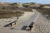 |
Die Dünen nördlich Pervalka über dem ehemaligen Dorf Negeln. Eine 9 km lange Strecke mit den wüstenartigen Landschaften. Stegpfade. |
|
 |
Žagare has long since been known for a special type of cherries. There are various varieties which only differ in terms of when they are ripe and productive. There are different types of trees. The cherries grow at nearly home, and that is an exclusive symbol of Žagare. |
|
 |
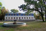
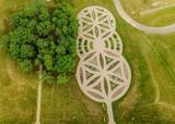
This botanical garden was opened in 1923 as a scholarly centre. The garden covers more than 60 hectares, and approximately 30 ha are open to the public. |
|
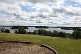 |
This park is located in the northern part of the Žemaitija Highlands, and much of it is taken up by Lake Plateliai. The park was established to protect lakes, rivers, wetlands and forest ecosystems, as well as the local cultural environment.
|
|
 |
This is Lithuania’s largest mossy swamp, and the Čepkeliu Nature Reserve was established to protect it. Before visiting the swamp, you must register at the Dzūkijos National Park’s visitor centre (Marcinkonys, Šilagėlių gatve 11). |
|
 |
One of the oldest botanical parks in Lithuania, this one was opened by Izidoras Navidanskas in 1928, when he was only 16. In 1965, the park because the Žemaitija botanical park, and Navidanskas and his son, Rapolas, who is the current owner, did a lot to expand it. |
|
 |
Tītuvēnu reģionālais parks (Tytuvėnų regioninis parkas) dibināts 1992. gadā. Parkam raksturīga ainavu daudzveidība – te ir sastopami lieli mežu masīvi, purvi, ezeri, upītes. Šejienes reljefa veidotājs tāpat kā citur Baltijas valstīs ir bijis ledājs, kas atnesis un atstājis aiz sevis garas laukakmeņu grēdas. Kopumā parkā ir konstatētas 603 augu un 787 dzīvnieku sugas. Parkā aug veci un dabiski boreālie (ziemeļu) meži, veci un jaukti platlapju meži ar ozoliem, liepām, kļavām, ošiem un gobām, sugām bagāti egļu meži, staignāju meži, nogāžu un gravu meži, purvaini meži un aluviālie (pārplūstošie) meži. Parkā esošās pļavas un tīrumi ir nozīmīga dzērvju atpūtas vieta migrāciju laikā, kad te pulcējās tūkstošiem putnu. Šiluvas baznīca un Tītuvēnu klosteris ir svētceļnieku galamērķis vairāk nekā 500 gadu garumā. |
|
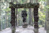 |
Eine große parabolische Düne mit einer Ausstellung der Holzskulpturen unter freiem Himmel, die der litauischen Mythologie gewidmet sind. Die Skulpturen haben litauische Meister der angewandten Kunst angefertigt. |
|
|
|
Eine der malerischischen Burgberge am Fluss Nemunas mit schöner Sicht aufs Flusstal. In 13 – 14 Jh. befand sich hier eine militäre Festung, die nicht erhalten ist. |
|
|
|
Kauņas jūras reģionālais parks (Kauno marių regioninis parkas) dibināts 1992. gadā. Tas ietver Nemunas HES uzpludināto posmu – lielāko Lietuvas ūdenskrātuvi no Kauņas līdz Piļonas (Piliuona) ciemam. Viena no nozīmīgākajām parka vērtībām ir ainava, kas veidojusies ilgā cilvēka un dabas mijiedarbībā. Parkā konstatētas 950 augu sugas, 600 dzīvnieku, t.sk. - 34 zivju sugas. Parka nozīmīgas dabas vērtības ir meži, augstie purvi, kadiķu audze. Parkā ir apskatāmi dažādu vēsturisko periodu liecinieki – senču pilskalni, Pažaislis klosteris, Kauņas cietokšņa Piektais forts, kā arī Rumšišķes (Rumšiškės) brīvdabas muzejs – viens no lielākajiem (195 ha) šāda veida muzejiem Eiropā. Vaišvīdavā (Vaišvydava) ir izveidots parka apmeklētāju centrs, parkā ir dabas takas, piemēram, Žiegždriai ģeoloģiskā taka un Dubravos izziņas taka. |
|
 |
Located on an island in Lake Dviragio, the Salu Estate and its park, when viewed from above, are reminiscent of the boundaries of Lithuania. The park to the east of the estate is a mixed-type park and is one of the oldest ones in Lithuania. Back in the day, it was a forest park where trees were never cut down. The park featured maple, linden, elm, aspen and other local trees, and they are now around 200 years old. A winding path links the alley to a park trail by the lake. The various plants and fragments of alleys have survived to the present day. |
|
 |
This museum was established in 2014 in partnership with the Siauliai University botanical garden. The museum is 85 m long and 40 m wide on a territory that covers 0.34 ha. |
|
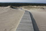 |
This is the only place in the Baltic States where there is such a vast territory of open-air sand dunes which still change the local terrain very actively because of the wind. The only Sea Museum and Dolphinarium in the Baltic States can be found here.
|
|
 |
This park covers the Nemuna River valley between the villages of Seredžius and Geldaudišķis, with lovely views of castle hills, medieval castles, aristocratic estates, etc., along the shores.
|
|
 |
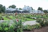
The botanical garden was established in 1993 in the lovely Dane River valley. It covers approximately 9.3 hectares, and in 2002, it was given the status of a dendrological park. |
|
 |
1855, als einen Schiffahrtsweg getieft wurde, wurde im Haff unerwartet eine Bernsteinablagerung gefundet. In der Zeit zwischen 1860 und 1890 wurde dort 2250 Tonen Bernstein gewonnen, einbezogen einzigartige Bernsteingegenstände aus der Jungsteinzeit und der Bronsezeit. |
|
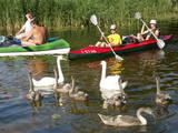 |
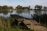
This was the first national park in Lithuania, and it is in the northern part of the Aukštaitija Higland, where hillocks interweave with lots of little lakes and ethnographic villages. Many of the lakes are connected with streams, forming long chains of lakes that are perfect for water tourists.
|
|
 |
This territory is Lithuania’s most forested area, and people here have always lived in accordance with nature. Local treasures include berries, mushrooms, honey, clean water from streams and rivers, etc. People here have engaged in various crafts, as well as in beekeeping.
|
|
 |
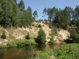
The terrain in this territory was created during the Ice Age. There are the ancient river valleys of the Minija, Salantas and Erla rivers, along with groups of rocks.
|
|
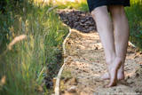 |
Enjoy nature with all of your senses in the Survilai village tourism farm, which is a Swiss village in the Jonavos district. Walk down paths barefoot! The paths are covered with pine cones, puddles, peat, clay, granite, smooth glass, pine needles, hay, an obstacle course, etc. The path is more than a kilometre long, and you will feel unbelievable and positive emotions, as well as an inflow of energy. |
|


