
| No | Name | Description |
|---|---|---|
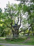 |
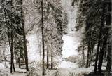
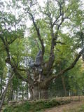
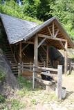
This park dates back to the mid-18th century and is to the south of Lake Stelmuže. There are winding trails on all sides of the hillock that lead to the Christ the King Church, with linden, maple, oak, birch, fir, elm and pine trees. At the foot of the hillock is the Laime stream, and visitors are welcome to stroll along the alley of oak trees. The oldest and fattest oak tree in Lithuania is one of the oldest ones in Europe. It is though that it is 1,500 to 2,000 ears old, and its record-setting diameter is 3.5 metres (eight or nine people linking hands are needed to encircle it). The tree is 23 m high. |
|
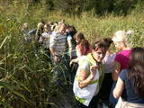 |
Kaut arī Augštaitijas nacionālo parku uzskata par floristiskā ziņā ļoti bagātu teritoriju, šī ir vienīgā vieta, kur varam iepazīt augu valsts bagātību. To īstenot palīdz takas malās izvietotie informācijas stendi. 3,8 km garās lokveida takas sākums ir meklējams Palūšē, Lūšu (Lūšiai) ezera galējā austrumu punktā. Taka ved gar ezera krastu, mežainām kāpām, nelielu strautu ielejām un pa purvāju. Nenomaldīties palīdz krāsu marķējums uz koku stumbriem. |
|
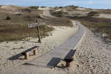 |
Die Dünen nördlich Pervalka über dem ehemaligen Dorf Negeln. Eine 9 km lange Strecke mit den wüstenartigen Landschaften. Stegpfade. |
|
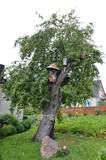 |
The oldest apple tree in Lithuania is a forest apple tree and is part of the country's botanical heritage and the only protected apple tree in Lithuania. |
|
 |
Žagare has long since been known for a special type of cherries. There are various varieties which only differ in terms of when they are ripe and productive. There are different types of trees. The cherries grow at nearly home, and that is an exclusive symbol of Žagare. |
|
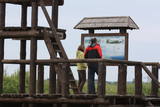 |
Reškutenu (Reškutėnai) ciema apkārtnē ir atjaunots neliels mitrājs, kura malā uzcelts putnu vērošanas tornis. Ja paveicas, pavasaros te var dzirdēt vai redzēt tādas retas un aizsargājamas putnu sugas kā ķikutu Gallinago media, ormanīti Porzana porzana, melnkakla dūkuri Podiceps nigricollis, griezi Crex crex u.c. Ciema ainava īpaši pievilcīga ir pieneņu un ābeļu ziedēšanas laikā. No putnu vērošanas torņa var redzēt vietas, kur akmens laikmetā dzīvojuši cilvēki. Blakus esošajā purvainajā pļavā bijis ezera līcis, kur tika būvēti ciemati līdzīgi kā Āraišu ezerpils gadījumā. |
|
 |
Veisieji reģionālais parks (Veisiejų regioninis parkas) veidots (1992.g.) Sudavas augstienes (Sūduvos aukštuma) ainavu, bioloģiskās daudzveidības un kultūras pieminekļu aizsardzībai. Viena no parka bagātībām ir ezeri, kuru iegarenās formas liecina par ledāja darbības rezultātu. Pēdējā apledojuma laikā šeit atradusies ledāja mala. Ezerus (kopā – 37) ieskauj lielāki meža masīvi uz kontinentālām (iekšzemes) kāpām, kas piemēroti atpūtai dabā, dabas vērošanai, ogošanai un sēņošanai. Parkā ir iekārtotas peldvietas, kur patīkami gremdēties vasaras tveicē, izveidotas dabas takas, bet mazās upītes, kas savieno ezerus, ir piemērotas braucieniem ar kanoe laivām. Veisieji reģionālā parka teritorijā ir liela augu un dzīvnieku daudzveidība. Šeit tiek aizsargātas arī tādas retas sugas kā Eiropas kokuvarde Hyla arborea (parka simbols), purva bruņurupucis Emys orbicularis, dažādas orhideju sugas u.c. |
|
 |
In der Umgebung von der 52 m hohen Parniddenen Düne sind die im 18. Jh. bei einem Holzeinschlag entstandene Wanderdünen zu sehen! Aussichtsplatz. |
|
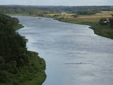 |
This lovely part of the Nemuna River between Alytus and Pakuonis meanders through cliffs that are up to 40 m high.
|
|
 |
This territory in the northern part of the Dzūkija Highlands with lots of hillocks and lakes. The most interesting tourist destination is Velnio duobė (Devil’s Flowerbed) – a funnel-shaped hole that is up to 40 m deep and 200 m wide and is thought to have originated during the Ice Age.
|
|
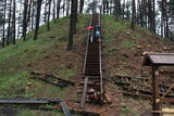 |
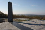
Viens no lielākajiem Augštaitijas pilskalniem, kas 2011. g. pēc vērienīgiem rekonstrukcijas darbiem ir izzināms jaunā kvalitātē - gan no infrastruktūras, gan arī ainaviskā viedokļa, jo iepriekš biezais pamežs (tagad retināts) traucēja uztvert iespaidīgo objektu. Arī no pilskalna plakuma paveras labs skats uz diviem blakus esošajiem ezeriem. Tā virsotnē apskatāms piemiņas akmens, kas vēsta par pirmā Lietuvas valsts prezidenta Antana Smetona (Antanas Smetona) apmeklējumu 1934. g. viņa 60 gadu jubilejā. Pilskalns it ticis apdzīvots jau I tūkstošgadē pirms Kristus. Uzskata, ka 14. – 15. gs. te atradusies hronikās aprakstītā Linkmenu pils. Jaunizveidotā taka pilskalnu savieno ar vēl vienu populāru apskates objektu – Ladakalni. |
|
 |
The “backbone” to this park is the valley of the Šventoji (Holy) River. One of the most impressive Devonian cliffs in Lithuania can be seen from the river – Vetygalos atodanga. On the shores of the Varius stream is a cliff made of quartz and sand – Variaus atodanga. 6 km to the S of Anykščiai is Lithuania’s second largest rock (5.7 m high, ~100 m3) – Puntukas akmuo.
|
|
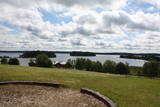 |
This park is located in the northern part of the Žemaitija Highlands, and much of it is taken up by Lake Plateliai. The park was established to protect lakes, rivers, wetlands and forest ecosystems, as well as the local cultural environment.
|
|
 |
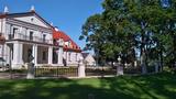
The Palanga Botanical Garden surrounds the Palanga Amber Museum and is one of Lithuania's most beautiful and well-kept parks. It is in the area of the St Birute Forest, and it is familiarly known as the Birute Park. The park covers 101.3 ha of land, and offers a wide variety of landscapes, carefully organised trails, flowerbeds, two ponds and small architectural elements. |
|
 |
Viens no iespaidīgākajiem nacionālā parka pilskalniem, kura piekājē atradusies senpilsēta. Arheoloģisko izrakumu gaitā te atrastas kuršu senlietas. Tiesa, mežs un biezais augājs traucē uztvert šī nozīmīgā arheoloģijas pieminekļa patiesos apjomus un formu. Uz pilskalnu vasarās ved izpļauta taka. Ja esat Žemaišu Kalvarijas pusē un atliek brīvs brīdis, tad savā maršrutā var iekļaut arī šo apskates objektu. |
|
 |
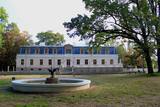
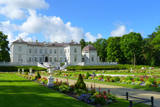
This mixed-type park dates back to the latter half of the 19th century and has remained all but unchanged. It is in a lovely place between two lakes, and its spatial structure was preserved when it was restored. The park covers 10 ha and has two parts. One is a fairly precisely rectangular territory alongside the state, surrounded by a stand of linden trees and introduced trees. The other part has a natural forest. The largest oak tree in the park has been declared to be a protected element of natural heritage. The mighty trunk of the tree is 6.3 m around, has a 2m diameter and stands 30.5 m high. |
|
 |
This is the thickest English oak (Quercus robur) in Lithuania, with a circumference of 9.4 m (as opposed to the Kaive oak in Latvia, which has a circumference of 10.18 m).
|
|
 |
The park was established to protect the Venta River valley and the landscapes that are around its tributaries. On the west bank of the Venta, at Papilė, there is a cliff from the Jurassic period which is unique in the Baltic States, has been known since 1925, and has layers in which more than 300 forms of life have been identified over the course of time.
|
|
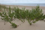 |
The territory is established in order to protect the dunes and the seashore habitats. There are beautiful beaches and wooded dunes, and the paved Klaipēda–Palanga bikeway trails through the park, which is worth travelling at full length. |
|
 |
The terrain in this territory was created during the Ice Age. There are the ancient river valleys of the Minija, Salantas and Erla rivers, along with groups of rocks.
|
|


