
| No | Name | Description |
|---|---|---|
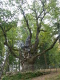 |
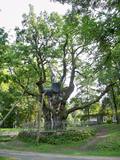
This is the thickest English oak (Quercus robur) in Lithuania, with a circumference of 9.4 m (as opposed to the Kaive oak in Latvia, which has a circumference of 10.18 m).
|
|
 |
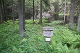
This territory is Lithuania’s most forested area, and people here have always lived in accordance with nature. Local treasures include berries, mushrooms, honey, clean water from streams and rivers, etc. People here have engaged in various crafts, as well as in beekeeping.
|
|
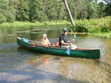 |
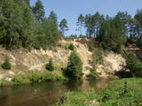
Ūla ir viena no skaistākajām un likumsakarīgi – arī populārākajām Lietuvas ūdenstūristu upēm. Tās galvenā pievilcība ir skaistā ainava ar augstajiem upes krastiem, kuros slejas iespaidīgas smilšu kraujas līdzīgi kā Irbes krastos Latvijā. Laivošanu var sākt no Mančagires (Mančiagirė) vai Zervinos ciemiem un turpināt līdz Ūlas ietekai Merķē un tālāk pa Merķi līdz pat Merķinei un Nemunai. Ūla nav plata, taču posmā no Zervinos ciema tajā nav neviena koku aizgāzuma vai cita šķēršļa, kuram laiva būtu jānes apkārt. Ašā straume, asie līkumi, dzidrais ūdens un tajā redzamā zemūdens pasaule rada patiesi patīkamu sajūtu! Upes krastos atrodas gan publiskas (apsaimnieko Lietuvas valsts meži), gan privātas ūdenstūristu apmetnes un atpūtas vietas. Šī ir vienīgā Baltijas upe, kur ūdenstūristiem ir jāpērk licence. Ūlas krastos atrodas divi interesanti apskates objekti – Ūlas atsegums (Ūlos atodanga) un spēcīgs avots – Ūlas acs (Ūlos akis). Savukārt, Merķe jau ir jau krietni platāka upe, taču ar acīm redzamu straumi un dažviet pat jaukām straujtecēm. Kaut arī Merķes krasti ir mazapdzīvoti, tajos atradīsim piemērotas nakšņošanas vietas. Pa Ūlu un Merķi no Zervinos līdz Merķinei sanāk „mierīgs” pusotras - divas dienas ilgs brauciens. |
|
 |
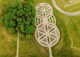
Četrus kilometrus garā lokveida un marķētā dabas taka meklējama Plateļu pilsētiņas ziemeļaustrumu daļā. Tā ved pa dažādiem biotopiem – mežu, purvu, ezera malu, atklājot dažādas ainavas un tajās mītošās augu, putnu un dzīvnieku sugas. Šī ir interesantākā un ainaviskākā no Žemaitijas nacionālā parka takām. |
|
 |
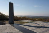
Vermutlich ein heidnischer Hügel. Schöner Blick auf die 6 Seenlandschaften. Ein Symbol vom Nationalpark. |
|
 |
In der Umgebung von der 52 m hohen Parniddenen Düne sind die im 18. Jh. bei einem Holzeinschlag entstandene Wanderdünen zu sehen! Aussichtsplatz. |
|
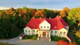 |
The Jakiškiu Estate was first mentioned in documents in the late 16th century. The estate had elements of Classicism in terms of its architecture. Among the buildings, the only ones that have survived are the mansion, an ice cellar and a steam-driven windmill. The estate has not been restored, so it is still authentic. Its artistic soul is preserved by various objects that remain from the time when people lived at the estate and from the Soviet era. Alongside the estate are a few fragments of a park, which covers approximately 2 ha. There is an ancient alley of linden trees that are on both sides of the entrance road, as well as several other valuable types of trees and a small pond. |
|
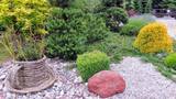 |
The botanical garden was established in 1993 in the lovely Dane River valley. It covers approximately 9.3 hectares, and in 2002, it was given the status of a dendrological park. |
|
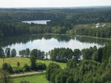 |
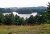
This territory is rich with forestland and lakes (some 285 in all). There are extensive opportunities for active recreation or calm leisure.
|
|
 |
This park dates back to the mid-18th century and is to the south of Lake Stelmuže. There are winding trails on all sides of the hillock that lead to the Christ the King Church, with linden, maple, oak, birch, fir, elm and pine trees. At the foot of the hillock is the Laime stream, and visitors are welcome to stroll along the alley of oak trees. The oldest and fattest oak tree in Lithuania is one of the oldest ones in Europe. It is though that it is 1,500 to 2,000 ears old, and its record-setting diameter is 3.5 metres (eight or nine people linking hands are needed to encircle it). The tree is 23 m high. |
|
 |
Ja apskatīta kodolraķešu bāze, tad var iziet 3,2 km garo Ploštines izziņas taku, kas sākas turpat netālu. Taka ved cauri dažādiem mežu tipiem, iepazīstinot ar sikspārņu būrīšiem (cilvēka radītas sikspārņu dzīves vietas), apkaimes augiem un putniem, kā arī aizsargājamu dabas pieminekli – Pileļu avotu (Pilelio šaltinis). |
|
 |
In the central part of the Žemaitija Highland, this park was established to protect local landscapes. Lithuania’s highest hillocks are found here – Mėdvegalis (235 m above sea level) and Šatrija (229 m). There are also other hillocks which offer a great view of the area – make up your own tour here.
|
|
 |
This museum was established in 2014 in partnership with the Siauliai University botanical garden. The museum is 85 m long and 40 m wide on a territory that covers 0.34 ha. |
|
 |
Lietuvas lielākais sūnu purvs, kura aizsardzības nolūkā ir izveidots Čepkeļu dabas rezervāts (Čepeklių gmatinis rezervatas). Tas izvietojies starp Dzūkijas nacionālā parka dienvidaustrumu daļu un Baltkrieviju. No Marcinkones pa smilšainu meža ceļu (~ 9 km turp - atpakaļ) ar kājām vai divriteni (arī nelielu tūrisma autobusu līdz 20 vietām) var nokļūt līdz purva malai, kur mežainās kāpās un purvā izveidota 1,5 km gara dabas taka un skatu tornis, no kura labi pārredzama purva rietumdaļa. Pirms došanās uz Čepkeļu purvu, ir jāreģistrējas Dzūkijas nacionālā parka apmeklētāju centrā (Šilagėlių gatve 11), kas meklējams aiz dzelzceļa pārbrauktuves. Te apskatāma neliela nacionālajam parkam un rezervātam veltīta ekspozīcija. |
|


