
| No | Name | Description |
|---|---|---|
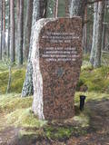 |
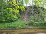
Around 6 km in length and an isolated route stretching between Ragaciems and Klapkalnciems where, as stories about olden days tell, robbers used to attack travelers. Around 1.5 km before Klapkalnciems (going from the side of Ragaciems), in the dune by the sea there is installed a commemorational stone dedicated to the Finnish jaeger battles. It was installed on December 09, 1997. The stone has "travelled" from the south-eastern part of Finland where in 1940 it served as an anti-tank defense. In the monument, there are engraved the words, "Here during World War I, from August 1916 to December fought the Finnish yeagers". In turn, in Klapkalnciems there is installed a commemorational stone in the place where there are buried five Finnish soldiers. |
|
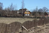 |
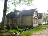
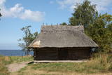
To the North-west from the Pitrags Baptist church (in the direction of the sea) is a fishing and farming homestead, Kurgati, which was established in the 1930s. This brought new building elements to the Liv Shore – a split roof end which was not typical of buildings in Liv villages. |
|
 |
Svētkalnā atradusies krustnešu nocietinātā pils. Zemgaļiem to nebija pa spēkam ieņemt, tādēļ, nodedzinādami savu pili Tērvetes pilskalnā (1286. g.), tie aizgāja uz Raktes (Žagares) novadu Lietuvā. Kad Svētkalna nocietinājumi bija zaudējusi savu militāro nozīmi, krustneši to nojauca. 1701. g. Ziemeļu kara laikā Svētkalnā atradās zviedru armijas nocietinātā apmetne, no kā arī cēlies vietvārds. Domājams, ka pirms tam šajā vietā atradusies seno zemgaļu svētvieta. No Svētkalna paveras viena no skaistākajām un biežāk fotografētajām Tērvetes ainavām. |
|
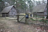 |
Approximately 200 metres to the North-East from the Liv People's Centre, along the Mazirbe-Košrags road, there is the Seppes homestead. The little log granary was built in the 1920s and 1930s by an Estonian fisherman and builder who arrived in Mazirbe from Saaremaa. He was called Jēkabs Jaga. On the other side of the road is the Kalši home, which was built in the early 20th century. It has been restored, but the bricks that were made in a local kiln were preserved for its walls. |
|
 |
The cosy land road along the sea is 1 km long, and it offers a look at the wonderful aspects of the village. To the right are rocks from the sea, as well as miniature flower gardens on the seashore with tempting benches and overturned boats. On the side of the shore is the Kaltene library, which is more than 100 years ago. It was initially a summer home for Baron Nolken, and it was built in 1899. Later it was rebuilt several times and took on new roles. An elementary school was installed here in 1926, after which it became a club and then, in 1992, a primary school once again. The path runs along beautiful seashore homesteads, among which one can find the former homes of old fishermen and ship builders such as Burliņi. At one time, the Žulnieki portage at Smilgas was the site of the kiln of blacksmith Pēteris Valdemārs. He was the main blacksmith for ships between Kaltene and Upesgrīve. (Source: Roja TIC) |
|
 |
Neliela apdzīvota un ainaviska vieta plašajā Skrobļa (Skroblus) strauta ielejā. Ciema austrumu pusē atrodas Lietuvas mērogā unikāls objekts – klēts - rija, kur no 1929. g. vietējie cilvēki uzveda un skatījās lauku teātra izrādes. Netālu no tās (uz abiem objektiem ir norādes) atrodas Skrobļa avoti (Skroblaus versmės), kas iztek no dziļas starppauguru ieplakas. Avotu gan ir appludinājis bebru uzceltais dambis. Dienvidos no ciema atrodas vecs grants karjers, kas ir viena no retajām vietām Baltijā, kur dabā ir atrodami krama ieža gabali, kas atnesti ar ledāju. |
|
 |
This is an ancient and important place for trade and craftsmanship on the left shore of the Rīga hydroelectric power plant reservoir. It rises some 15 m above the Daugava River. The Zemgale port that is described in historical documents is thought to have been located alongside the castle hill and at the mouth of the little Varžupīte stream. Antiquities that have been dug up here suggest that the castle hill and its adjoining ancient settlement were populated until the late 12th century, when the importance of Daugmale began to shrink because of rapidly growing Rīga. The foundations of the castle hill have been shored up. |
|
 |
Eine der größten befestigten Siedlungen im Bezirk Harju, befindert sich auf einer Erhebung des natürlichen Kliffs Nordestlands. |
|
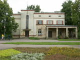 |
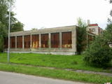
The building was erected during the first period of Latvian independence, and it maintained its functions for a long time. The building is located at Tukuma Street 30. Beginning in 1940, the post office had an automated telephone central. The Postal Service no longer uses it, and the building can only be viewed from the outside. |
|
 |
Beliebte und eine der ältesten Straßen in Jurmala zwischen Dzintari und Majori. Die 1,1 km lange Straße mit Wirtshäusern, Sommercafés und Souvenirladen. |
|
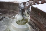 |
Built in the turn of the19th to 20th century. Next to it-on the right bank of the river Vēršupīte, there is located one of the most popular Latvian sulphur water springs, called "Small lizard". The spring runs out from a stone-designed lizard sculptured in 1949 (Sculptor J. Bajārs). Its water is healthy for using both internally and externally. Not far from the pavilion there can be found Jānis Lībietis alley sign. J. Lībietis worked in the position of a director for the sulphur water spring authority of Kemeri from 1928 to 1944. |
|
 |
Tiek uzskatīta par vecāko alus darītavu Ziemeļeiropā. Tā tika uzcelta 1878. gadā, un tās pirmais īpašnieks bija grāfs Emanuels fon Zīverss (Sievers), Cēsu pils muižas saimnieks. Savukārt 1922. gadā alus darītavu pārpirka Cēsu uzņēmēji un sāka tur ražot arī vīnu, sulas un minerālūdeni. Uzņēmums "Cēsu alus" šeit alu un atspirdzinošus dzērienus ražoja no 1976. līdz 2001. gadam, bet šobrīd tas ir pārcēlies uz jaunām telpām. Šobrīd ēkā tiek organizētas dažādas izstādes, kā arī ēku var apskatīt no ārpuses. |
|
 |
Altja village in Lahemaa National Park was first recorded in writing in 1465. It is a typical seaside village with houses along one street. Traditional farmsteads of Uustalu and Toomarahva from the late 19th C are open to visitors. Renovated fishnet sheds are located on Altja Cape. The village has a swing and a tavern (Altja Kõrts) providing national food |
|
 |
Kolkja, Kasepää and Varnja are another example of one-street villages of Old Believers who fled to Estonia from Russia in the 17th and 18th centuries. |
|
 |
This is the one street in Ķemeri where the towns' wooden buildings have been preserved to the greatest degree. Turning onto Durbes Street from Karogu Street, you will find the Miervaldis Ķemers Museum, which is focused on the well known Latvian cultural activist, pastor and painter (1902-1980). The museum is at Durbes Street 21. |
|
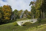 |
Temple Hill is steep (with artificially created steepness) and about 30 m high, and it is opposite Marijas Island. It is an ancient Lettigalian castle hill, 80 m long and 40 m wide, with several artificial ramparts. One of the oldest objects found in the region is an axe from the 2nd to 3rd millennium BC. Archaeologists believe that the island was populated at that time. There was a Lettigalian castle on the hill during the 10th and 11th century, but it was sacked by the Holy Crusade. The surface of the castle hill was transformed comparatively recently in 1807, when a granite rotunda was built there in honour of Russian Field Marshall Sheremetev and Swedish captain Wulff. The view of Lake Alūksne and the town is one of the most beautiful ones in all Vidzeme. The Sun Bridge (1937) is also worth a look. A wooden viewing platform is nearby. |
|
 |
Находится на ул. Базницас, д. 17. Здание построено в XVII веке, как жилой дом кулдигского бургомистра. В 1701 году здесь гостил король Швеции Карл XII, который в передней оставил огромный сундук (2 х 2,5 м), на который после реставрации можно взглянуть и сегодня. |
|
 |
No Vilces muižas pa pastaigu taku var aiziet līdz pilskalnam (12 m virs apkārtnes, labiekārtots), kas atrodas Vilces un Rukūzes upīšu satekā. Atradumi liecina, ka cilvēku apmetne šeit ir pastāvējusi jau vidējā dzelzs laikmetā. Pilskalna piekājē atrodas atpūtai labiekārtotā Zaķu pļava. Nostāsti vēsta, ka Vilces grava bijusi laupītāja Kaupēna slēpšanās vieta. |
|
 |
Old Believers, who fled persecution from the Russian Orthodox church because of their refusal to adapt to church reforms, settled down on the western shore of Lake Peipsi in the 17th and 18th centuries. |
|
 |
A straight street which runs through Ķemeri in the northwestern-southeastern direction. The street's name is a proof that it is the former historical boundary between the regions of Vidzeme and Kurzeme. Near the intersection of Robežu and Tukuma streets, you can notice the former pharmacy building-the memory of the former resort of the all-union significance. On the walls there has survived the pharmacy-related symbolism. |
|
