
| No | Name | Description |
|---|---|---|
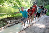 |
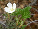
The first barefoot trail created in the Baltic States in the recreation complex "Valguma pasaule", which is located on the forested shores of Lake Valguma. When walking on the path, the feet "massage" sand, wood chips, clay, peat, gravel, cones and various other materials. |
|
 |
Einer der ausgeprägten Kaps der lettischen Küste mit Niederungsauen und einem in 1875 gebauten Leuchtturm. |
|
 |
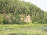
This nature park is located in the most distinct part of the Dagda hillocks of the Latgale highlands. Part of it is the deepest lake in the Baltic States -- Lake Drīdzis, which is 63.1 metres deep and has nine islands. Also there is Lake Otis. The loveliest views can be watched from the ancient Lettigalian castle hill that is known as Sauleskalns, and from the eastern shores of Lake Drīdzis. Accommodations are available near the lake. |
|
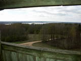 |
This is one of the highest points among the hillocks of the Selonian area of Zemgale – Borīškalns Hill. From the tower, you will see Lake Sauka, as well as the forests and farmland which surround it. The “Kalna Ļūdāni” farm is nearby, and its owner uses his livestock to help to maintain the surrounding landscape.
|
|
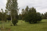 |
Work on the arboretum, which covers 15 hectares of land, began in 1968, and it was meant to be a landscape park. The first plants were planted in 1972. During the fierce winter of 1976, sadly, many of the plants froze. In 1987, the park was redesigned. At that time it had 234 types of deciduous trees, coniferous trees and bushes. There are signs showing the Latin and Latvian names of the various plants
|
|
 |
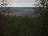
Elka Hill is one of the highest surfaces in the western part of the Vidzeme highlands, and it offers a lovely and broad view to the North. There is a small parking lot, a TV and radio tower, and the place where the Gauja River is thought to originate.
|
|
 |
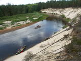
One of the most beautiful areas along the Venta River and its tributary, the Šķērvelis River. The river valleys and gullies along them are quite deep, and dolomite and sandstone cliffs can be spotted here and there. There are also rapids on the river. The largest cliffs in Kurzeme – the Ātraiskalns and Gobdziņi cliffs – can be seen on the banks of the Venta. The Lēni Catholic Church is near the restricted area. There are no tourist elements in the restricted territory at this time. The Venta is a popular destination for water tourists, however, from Nīgrande to Kuldīga. |
|
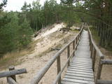 |
The trail climbs up and down along the bluffs of lower River Pilsupe and reveals a fascinating sight of three white dune exposures (the largest is called the White Dune). The trail is 900m long, and the White Dune is ca 20m high. It has formed ca 6000 years ago, in the period of the Littorina Sea which is a foregoer of the Baltic Sea. Here the first Stone Age settlement on the North Western coast of Latvia has been found in 1934 by geologist S. Burhards. In the sand, some 500m from the sea, he found some pottery fragments, a sandstone hone, a piece of flint, parts of bones and an amber bead. He handed the findings over to the National Museum of History. In October 1934, the site was checked by archaeologist E. Šturms, who found the archaeological layer, typical for such settlements, in the landslides of the Pilsupe riverbanks. In 1936 he started larger excavations to continue by 1938. Totally seven, chronologically different settlements were detected and many artefacts found, including fragments of the so called Sārnate and pit-comb pottery, as well as some pieces of corded pottery. Based on these findings, the settlement is dated back to the beginning or middle of the 3rd millenary B.C., and it has been inhabited till the beginning of the 2nd millenary B.C. Especially remarkable are three clay figures in human shape which have probably been used for some religious cult purposes. Since 1993, archaeologist Ilzes Loze has discovered several pit-comb ware culture settlements in large area around Pūrciems village. They are known in research literature as „the Ģipka settlements”. |
|
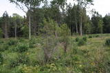 |
One of few places in Latvia (around 1 km to the North from Lapmezciems) where used to be beautiful juniper meadows. Since no agriculture activity (grass cutting, cattle grazing) has been implemented in the area, juniper meadows are overgrowing and disappearing. To save the area sustainable management is needed. Slitere National Park with Blue Mountain cliff and Slitere lighthouse is located in short distance from Kadiku nora (Juniper meadow).
|
|
 |
Augstā un purva vidusdaļā - pārejas tipa purvs, putniem nozīmīga vieta. Apmekļējumiem nav piemērota infrastruktūras trūkuma un sugu aizsardzības nolūkā. |
|
 |
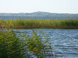
The main “treasure” in this restricted area is the shallow and eutrophic lake, which is home to many important birds. The lake and its flood-land meadows also feature many different plants. The Svētupe River flows from the northern part of the lake.
|
|
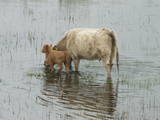 |
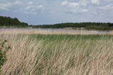
The shallow and mostly overgrown (65% of its surface) Lake Engure is one of those Latvian lakes which are most favoured by birds. It is a location which is governed by the Ramsar Convention on Wetlands, and 186 species of nesting birds have been identified there. The area is also distinguished by great botanical diversity (more than 800 kinds of plants). The coastline varies between sandy beaches and seashore meadows. There are forests, fishing villages and damp areas which ensure a great diversity in landscapes and species. The flood-land plains of the lake and the sea are grazing grounds for wild livestock – horses, blue cows, etc. Several bird-watching towers are open to visitors, as is the Orchid trail. The Centre for Ornithological Research is located on the eastern bank of Lake Engure. A unique floating house built by ornithologists is located on the lake. The territory is appropriate not just for holiday-makers, but also for hikers, bicyclists and bird-watchers. A leisure area and a small exhibition are located close to the ornithological research centre. |
|
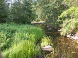 |
A distinct area of the lower reaches of the Vitrupe River, with small sandstone cliffs and many rare species of plants and molluscs. Visitors can visit the Ķirbiži Forest Museum and its information and botany trail. It weaves along both banks of the river and allows people to look at the most typical examples of flora in the region. The noble Vāloži oak tree is a key element there.
|
|
|
|
33,5 m augstais tornis tikai nedaudz paceļas virs priežu galotnēm. Tas meklējams Dzintaru mežaparkā, kas ir ģimenēm ar bērniem draudzīga vieta. No torņa redzami Jūrmalas meži, augstākās ēkas (sanatorijas, viesnīcas) un Rīgas jūras līča ūdeņi. |
|
 |
This is an area that is full of legend and tale. There is a stiff hillock, which stands about 66 metres above the surrounding land. From its southern side, you can see the Burtnieki lowlands. The tower, however, is not open to the public.
|
|
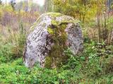 |
The Devil Stone of Ubagova (Čorta kameņs). The cult place is situated in the Southern side of the
village Ubagova 30m to the N NW from the cemetery of the village. According to the legend, there are
ghosts so you shouldn’t walk there alone because they can trap you in the woods. The boulder is about 1.6
m high. The surface is smooth, without any cuts.
|
|
 |
This comparatively large territory is found to the South of the Irbe River and Stende River, and it is unique with more or less virginal forests and dunes. The Irbe River has a system of ancient tributaries, and the Dižpurvs swamp is parallel to the shoreline. The Irbe has become a popular river for water tourism in recent years, but the tourist infrastructure on its banks remains insufficient. Territory has good road connections and has potential for nature education activities. |
|
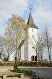 |
The Priekule Lutheran Church was built around 1680 and rebuilt a century later, in 1892. In 2005, the church tower was improved, and visitors to the church can now use it as a viewing platform. They can see the place where Icarus of Priekule supposedly made his first “flight.” |
|
 |
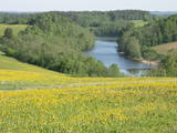
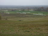
A beautiful part of the Rēzekne-Dagda-Krāslava road – along two km or so, you can see Lake Rāzna and Mākoņkalns hill, which is 10 km away on the other shore of the lake. |
|
 |
Atrodas dienvidos no Vienības nama. Skvērs veidots 19. gs. otrajā pusē. Tajā atrodas vairāki ievērības cienīgi objekti: strūklaka (20. gs. 20. gadi), latviešu tautas dzejnieka Andreja Pumpura krūšu tēls, piemiņas akmens Nevainīgajiem sarkanā terora upuriem un Sv. Aleksandra Ņevska pareizticīgo kapela. Vienības ielas otrā pusē paceļas iespaidīgā Daugavpils universitātes ēka ar Raiņa pieminekli un saules pulksteni priekšplānā. |
|


